Margarette Falls
- 3:00 miles
- 2:26 minutes
- 796 foot elevation gain
I headed out on Sunday morning to Greene County, TN for a return hike to beautiful Margarette Falls. I was accompanied by 2/3 of the Mandalorian Steelers geocaching team, Larry and Melissa.
Melissa and I have teamed up for several hikes recently, but it has been a long time since I’ve hiked with Larry. He is now off on weekends, so hopefully we can get together for more hikes.
They picked me up at 9:00 am and Larry drove us to the trailhead, a journey of about an hour from my house. It was nice to sit in the back seat for a change and enjoy the ride. Geopup Andy sat on my lap the whole way. I guess he was afraid of getting Larry’s truck dirty.
There was only one other truck in the parking lot when we arrived. It looked as if there would not be a big crowd at the falls today.
We hit the trail at 10:05 am. The first half mile of this hike is a gentle stroll along a well graded rock road. This was my third trip here, and Larry and Melissa’s second. We weren’t planning for any geocaching today. We just wanted to hike to the falls and back. I had already found the two caches here, and Larry has taken a bit of a hiatus from the game. Melissa just likes to come along for the hike.

We had seen some snow flurries in town the last couple of days, so hoped we might see some on the ground here in the mountains. There was a small amount scattered about near the beginning of the trail.

It was a cool 33° when we started the hike, and the skies were sunny and clear. That sun was hidden once we got into the hollow that follows Dry Creek toward the falls. At the .5 mark, the forest road we were following ends. Signs point straight ahead for Margarette Falls and a slight right for Bullen Hollow, while a sign off to the left marks the trail head for Phillips Hollow.

Melissa saw a steep, rocky trail ahead of us and said, “We have to go up that?!” Fortunately, that was the trail for Bullen Hollow, and our path was a much gentler climb. We soon passed a young man hiking back down from the falls alone. We would have the falls to ourselves today.
The trail follows Dry Creek closely. There is one set of cascades after another, and we stopped many times to take pictures.

Melissa’s eagle eyes also spotted the smaller treasures along the way such as beautiful ferns and tiny mushrooms.


I paused along the way to capture a snowy log covered in lichen.

We were making our way slowly up the trail, continuing to stop and photograph the water. The deep shadows in the hollow were very conducive to capturing the movement of the water, and I played with the long-exposure setting on my phone.

We also spotted some pretty icicles along the way.

This trail was once listed as strenuous and included at least four creek crossings each way. However, the trail was rerouted in 2012 and is now more moderate. Where it used to travel right along the creek, there are now sections that are routed higher on the hillside above the creek.
About 35 minutes into the hike we arrived at the bridge that was built in 2012 to take you across the creek. I can imagine this was a tough crossing in the past. There are beautiful views both upstream and downstream from the bridge. Today it was a bit slick with ice.


Once you cross the bridge, the trail gets a bit rougher. There is one section here that is quite rocky, making it important to slow down and watch your footing. This is hard to do when the views of the creek are so beautiful.


After another 15 minutes of hiking, we reached the one remaining creek crossing for this hike. The creek is very wide and shallow here. Since they were wearing tennis shoes, Larry and Melissa carefully rock-hopped across. I had let Andy off-leash as we traversed the rocky areas, so that I wouldn’t trip over him or the leash. He dashed across the creek, through the water, and then turned to look back at me.

I picked my way across some large rocks at the water’s edge, and then carefully began crossing. I tried stepping on dry rocks whenever possible, but also stepped in the shallow water when rocks weren’t available. My boot are nicely waterproof as long as you don’t get in too deep.
I was at about the mid-way point and feeling proud of myself for staying dry. That is when Andy decided to come zooming back across, thoroughly splashing me in the process as he ran by. He turned and splashed back by me again, then waited at the other side for me to make it the last ten or fifteen feet.

The trail is less rocky on this side, but there are some steep spots. I remember having to just sit and slide on a previous trip, when these spots were snow covered. Today there was no snow on the trail, but we were seeing more on the vegetation and forest floor around us.

When Andy and I are hiking with Rob, he hangs close to him whenever possible. Today, he had a new hiking buddy, Larry.

The creek was just as beautiful here as it was on the lower stretches. We couldn’t resist stopping for more photos.

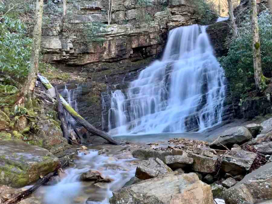
At last we reached the waterfall. With all of the rain we had experienced over the last few weeks, it was full and beautiful. We spent about 35 minutes here, taking pictures and just enjoying the sights and sounds of the rushing water.


For one set of photos, I picked Andy up to hold him. After playing in the creek, he was quite wet, and when I put him back down the front of my sweatshirt was soaked.


There is always a cool breeze coming off the falls when they are flowing this much. With the shade of the towering cliffs around us, it was chilly, especially with a wet sweatshirt.


We finally noticed that Andy was shivering as well, and decided it was time to start hiking back.

We had not gone far when the sun saturated the trail once again. We welcomed its warmth.
After crossing the creek once again, I put Andy back on his leash. We soon started passing other hikers, and were glad we had come as early as we did. Based on the number of people we passed, it was likely very crowded at the falls a few minutes later.

We picked our way carefully across the rocky area, or at least I did. Going down rough terrain is always harder for me than going up. The bridge was just as icy going across as it had been earlier in the morning.

We were soon back at the clearing that holds the three trail heads. We decided to walk over to see what the Phillips Hollow Trail looked like. It would not be a possibility today, since it begins with a very deep creek crossing. This was fine with us since this trail was marked on the sign as “most difficult”.
We made quick work of the last .5 mile to parking. We ended the hike less than 2 1/2 hours after we started. It was a short but beautiful hike, and I was happy to have spent time with Larry and Melissa.

Any hikes up Jenkins Mountain and Tank Hollow Branch in Hampton, TN?
Hello. We’ve not hiked to Jenkins Mountain, but we did hike to Tank Hollow Falls in April 2017. Here is the post for that day: https://antbedy.com/2017/04/11/april-8-2017/ . I noticed as we drove by Saturday that Tank Hollow Falls looked fuller than usual. This would be a good time to go there.