Pete’s Branch
- 2.77 miles
- 2:32 duration
- 694 foot elevation gain
- 20 creek crossings (4 in truck, 16 on foot)
- 2 events logged
- 4 geocaches found during hike (all resurrections)
- 2 geocaches visited after hike (1 previously found and 1 hidden by me)
- 2 geocaches logged after hike (1 FTF)
Groundspeak, the company that facilitates Geocaching by providing the website, rules, volunteer reviewers, etc., offered two new virtual souvenirs this week. A souvenir is just a badge of honor that shows up on your geocaching profile to show that you have accomplished something. The first of these souvenirs was called Goodbye 2019 and was awarded to cachers who find a cache or attend an event on December 31. The second was called Hello 2020 and is for logging a cache or attending an event on January 1.
To give folks the opportunity to claim those souvenirs, my friend Rudekoolaid (Angela) planned three events. The first was a goodbye event on New Years Eve, a “meet and eat” at La Carretta Mexican restaurant in Gray. We had a good group of folks stop by for it, with many sticking around to eat and others just dropping in to say hi.

For New Years Day, Angela planned two events. The first was at Dunkin Donuts in Colonial Heights at 9:00 am. Attending it were many of the same people who were together the night before, with at least two additional persons. After we had enjoyed breakfast and fun conversation, some of us headed out for the second event, a hike in Greene County.

I drove BART with passengers Rudekoolaid (Angela), LakeBum (Rob) and Mrs. Steelers (Melissa). Following us were Scouter James (Jim) and mamullins (Mary Ann). tncorgi (Mary) met us at the trailhead in Horse Creek Recreational Area at 11:00 am and climbed in my back seat with Melissa and Rob.

Since we had started the day with an hour long event at Dunkin Donuts, I did not bring Andy along for this hike. He was not at all happy with me when I left the house, carrying my backpack, and not taking him with me.
When helping Angela plan this hike, I had suggested this trail because I had heard that you could drive a good bit of it, leaving only .5 mile left to hike to the waterfall. I knew that driving it would require a high clearance vehicle and possibly 4WD, but felt certain BART (my 2013 Ram 2500) was up to the task.
Rob and I had attempted this hike once before, but not on a day I was driving my truck. We turned back at the first creek crossing because the water was too high and swift to wade across, especially on such a cold December day.

The water level was much lower today, and we were able to cross easily in our trucks. The first crossing was a breeze as the park service has “paved” the way at the crossing with concrete pavers. The forest road was somewhat bumpy but in fairly good condition for a gravel road.
Shortly after crossing the creek, Angela called out for me to stop because we had reached the location of the first cache we were seeking. All of us piled out of the vehicles and began searching the bank between the road and creek. After several minutes of searching, Rob called out that he had found it – about 50 feet from where the rest of us were looking.

Rather than all seven of us signing the log individually, we settled on a group name of First Day Cachers. Rob wrote this on the log, we all climbed back in the trucks, and traveled on.
When we reached the next creek crossing, it looked a bit rougher than the first. It did not have the nice pavers and had rocks sticking up in the crossing and on the road leading out of it on the other side. We headed across, and were able to make it without problems, but our ride started to become much bumpier here.
From this point on, the road was much rougher. We bounced across and off of rocks and ruts. At one point, I wasn’t sure whether we should continue because I couldn’t see what was over the next rise. Rob got out to walk up it and see if it was passable. The only problem was, if we decided it wasn’t, there was no good place to turn around on the narrow track.
Thankfully, he waved me on. I asked my other passengers if they wanted to get out and walk. Melissa decided that was a good plan since her stomach was already a little woozy from the drive here.
It was like riding a very bumpy roller coaster along this road. We bounced about inside the truck like pinballs. Angela shot a short video of our ride to show how bouncy it was.
Finally, we came to the third creek crossing. There was plenty of room for parking and to turn around here. We decided to leave the trucks here and continue on foot.

There was also another geocache nearby. Once again, Rob made the find on this one. It was up hill past a cable and signs that said No Trespassing. We took that to mean, “don’t drive up this road” and walked up it instead. This was a nice ammo can full of swag.

Back at the vehicles, we set out on the hiking portion of our adventure. First we had to cross the creek. It was wide at this point, but shallow enough to rock hop or simply wade across. Different members of the group elected to cross different ways. Angela was wearing Chaco shoes that dry quickly and no socks. Since she doesn’t have the balance for rock-hopping she waded. The rest of us were concerned that her feet would be too cold the rest of the hike, but she assured us she was fine.


Once we had crossed and were hiking along the road, I wished that I had chosen to drive it instead. It was actually smoother than what we had already traveled. I decided that once we had reached our destination, that I would head back ahead of the others to get the truck and drive in as far as possible to pick up Angela.
While she has made great strides in recovering from her stroke a year ago, it is still very difficult for her to hike. But she is determined. She is a warrior! At least the terrain was fairly level along this stretch. However, there were still a few roots and rocks that threaten to trip any hiker. Kicking one of those causes her great pain, but she continued on.

After hiking about .25 mile, we arrived at the site of the next cache. Despite the fact that we had so many eyes searching for it, we did not have any luck. This was a micro – from the description it was a bison tube – and was supposed to be hidden in a tree knot. However, the last finders reported that it was not in a knot. There are so many places to hide a micro in the woods. We spent about 13 minutes searching the forest before deciding to move on and look again coming back.

Continued along the forest road another .2 mile before coming to a junction and wide area for parking. We could have easily driven this far in and saved ourselves hiking an extra half mile or so. Past the parking area was another stream crossing, the first of seven that you encounter if you drive this far.

Just past this crossing was another geocache. This time it was Mary who made the find. She had to dig deep into a rotting stump to come up with it. Like the previous two we had found, this was a cache resurrection, having last been found over a year ago.

The log sheet was soaked, but Angela was prepared with supplies in her pack. She provided a fresh log sheet and baggie for us to sign and place in the cache.

We crossed another stream and continued following the trail toward Pete’s Branch Waterfall. There were no more caches to be found, but we still wanted to visit the waterfall since we had come this far.


Around the one mile mark of the hike, the terrain became steeper. We eventually came to a creek that Angela was unable to cross. The bank dropped off at a nearly perpendicular angle, with the creek flowing several feet below. There were two huge boulders in the creek that provided steps to cross, but the were too far apart for her to attempt with her bum leg and cane. She decided to sit and wait here for us to come back.
We continued the climb, and after hiking about 1.25 miles reached the falls.

Because the water levels were so low, they were mostly a trickle. However, it was a sheer drop of about 45 feet. I would say that in the rainy season they are spectacular, although all of the stream crossings would make reaching them tough.

Only Rob, Melissa and I went all the way to the base of the falls. Mary, Jim and Mary Ann stopped a couple hundred feet away to take a couple of photos, and then headed back.
The three of us spent some time taking photos and enjoying the falls. The ones of us at the base really give good perspective of their height.


I had brought Angela’s traveling buddy Pete with me, so that he could see the falls named for him. While he and Signal were taking a selfie, Rob photobombed them.


Melissa handed me her phone and said, “Will you take a picture?” So I did…

It was much later in the hike when she was looking at her pictures and realized what I had done.
After we had taken all the photos we wanted, we decided to head back. It was 1:20 by now and we were hungry. However, we didn’t want to eat at the falls and leave Angela sitting on the trail waiting for us.
We hiked back down to the point we had left her, but she wasn’t there. We hoped that she had headed back with the rest of our group when the arrived. Along the way we met a couple with a dog who looked much like my Andy. They asked if we were geocachers, and said that they had already chatted with some others who were just down the trail.
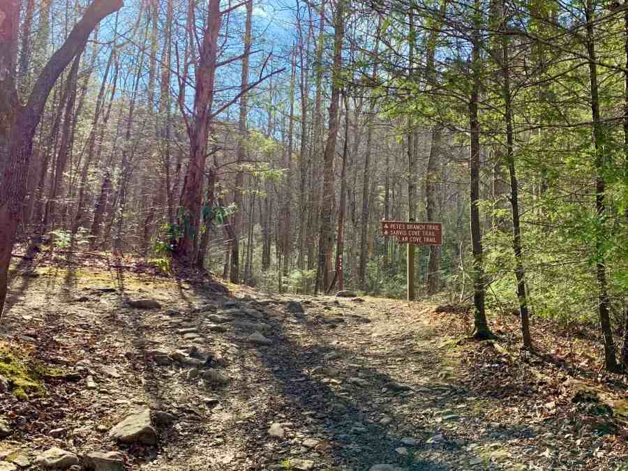
It was the site of the last geocache we had found where we finally caught up with Mary and Angela. They were waiting for us there. Mary Ann and Jim had elected to hike on to their truck and head for home. The rest of us took a picture next to the Pete’s Branch trail sign.


Mary’s back was bothering her so she stretched it by lying on a rock. As we crossed the creek, Angela nearly fell in but made a great recovery to stay on her feet.

After we crossed the creek, I told Angela that I was going to get the truck and come get her. She refused, saying that we needed to stop to look again for that cache we had not found earlier. I assured her that we could stop the truck to look again on our way out, but she stubbornly walked on down the trail. She is a warrior.
We did indeed stop to look for that cache again. Still not finding it, we decided to replace it since the cache owner has not been active for six or seven years. You can no longer hide caches in a National Forest without paying a permit fee, so if this one were to be archived, a new one couldn’t be placed here.
We replaced the cache with a bison tube that Angela had in her pack, and I put it in a knot hole in a tree as described in the hint.

As we continued our hike back to the truck, I saw an interesting type of fungus growing on a fallen trunk. It was not something I had seen before so I stopped to take a picture.

We made the last creek crossing, and were back at our vehicles. Here we picked up some of the trash left behind by stupid people, and then ate our long overdue lunch.

As we ate, we heard vehicles coming up the road behind us. Several 4WD vehicles approached and crossed the creek to continue the way we had hiked. The last two were very new looking Jeep Wranglers, one red and the other blue. A man was driving the red Jeep and a woman the blue. The license plate numbers were just one digit different from each other, so they were likely married. I thought it was interesting that they each had to drive their own and not ride together.
We also saw a pickup truck come from the opposite direction, and wondered where it had accessed the road. I dug out a paper map from my pack. It took a few minutes to figure out exactly where we were. The map must have been broken or the batteries were dead because I couldn’t find the little blue dot on it showing our current location. 🙂
While hiking I had noticed that the road branches off to the left just before the last parking area we had passed. The map shows that road crossing the mountain and winding around to meet the main road.
Once we had finished our lunch we loaded up and started the drive back to where Mary had left her car. It was just as bumpy driving out as it had been coming in. At one point, I heard a thump and looked back to see Angela rubbing her head where it had hit the side window. Thankfully the window did not break and she wasn’t concussed.
When we finally reached the main parking area, we stopped to let Mary out. We then started the drive back to Kingsport.
Angela was checking the geocaching app as we drove, to see if there were any caches we needed to find. There was one along our route that Rob and I had already logged, but that Angela had not. Since it was at a great location, I stopped so that she could find it.
This was the Earnest Fort House which is on the National Register of Historic Places. Built in 1782 this is the oldest “substantial” structure still standing in Tennessee. Bishop Francis Asbury stayed here many times during his travels in the area, and held worship services for what would eventually become Ebenezer Methodist Church.

Melissa and I were reading a sign near the door of the church while Angela logged the geocache in the guardrail across the street. I saw a car pull up, and a woman got out. I didn’t hear what she asked Angela, but heard her reply, “I’m picking up trash.” She held up some trash as evidence, and that seemed to satisfy the woman.

She then turned her attention to Melissa and me, and announced that she was the “keeper of the keys.” I replied, “Oh! Are you Wilhelmina?” When she answered yes I shook her hand and introduced myself, adding that I work for the United Methodist district office. I told her that since we were passing by I wanted to stop and show my friends this place since it is important in Methodist history. We had a nice discussion while Angela continued picking up trash and Rob and Melissa explored the cascade below the road toward the Nolichucky River.
Satisfied that we were not there to cause trouble or damage the building, Wilhelmina moved on. Eventually, we did as well.
We were on Interstate 81 driving north when our phones announced a new cache had published. It was a hide by BackWoodsAng, and not TOO far out of our way. I passed our exit and went to the next, and then we took some back roads to arrive at the cache location. There, we found no place nearby to park so I drove past the cache, turned around and came back, stopping in the road next to the cache location. Rob hopped out and climbed over the guardrail to grab the cache. He found a blank log sheet, proving that we were First to Find. He had to come back to the truck for a pen before signing the log.

Once he had replaced the cache, I drove him and Melissa to Ingles where they had left their vehicles earlier in the day.
Angela had again been looking at her app to see if there were any caches in the area that neither of us had found. She spotted one nearby and began directing me toward it. It turned out to be another cache hidden a few months ago by Ang. We logged it, and then knowing that new caches were being published and that I had hidden one just a couple of days ago, I started driving in the direction of it.
Sure enough, it published just in time for Angela to log the First to Find on it. I then drove her home, and returned home myself, arriving nine hours after I had left that morning. I was in time for a great dinner cooked by my mother-in-law, Martha which included black-eyed peas, a traditional New Year’s meal.
They say that what you do on New Year’s Day is a harbinger of what is to come for the rest of the year. I hope this means many miles of hiking, finding caches, visiting waterfalls, and spending quality time with friends and family.
