
The Channels
- 6.7 miles
- 6:00 duration
- 1348 foot elevation gain
- 1 event cache logged
As I explained in my December 26-27 blog post, there are several different types of geocaches that one can log. One of those types is an event. An event cache is the opportunity for cachers to gather at a specific time and place.
On January 1, 2019, New Cache Order (nCo) hosted an event at an amazing place in Virginia called The Channels. This was our opportunity to gather for a First Day hike and get the new year started off right. While this was promoted as an official geocaching event, friends and family were also invited.
Thirteen people met at the Brumley Mountain Trail trail head that morning. Six of those people were geocachers, and seven were muggles (the term we use for non-cachers). Most of the half dozen or so vehicles in the parking lot belonged to our group.
As we stood in the parking lot, someone said, “Who is our leader (for the hike)?” Everyone turned to look at me, so I reluctantly agreed to lead the hike. After all, I probably was the oldest person there. 
I encouraged everyone to go at their own pace, and we started up the trail at 9:00 am. This hike is not an easy one. The distance from parking to The Channels is three miles, and it is uphill all the way. Most of the hike is along forest roads, but some areas are rocky and require hikers to pay close attention to their footing. There are sections of the trail that are steep with 20% – 30% grades.
Since we have had a lot of rain in recent months, the trail was quite muddy in places. We even encountered a few areas where wet-weather streams had formed and were flowing along the trail.
The temperature was a moderate 50° when we started. The skies were cloudy, but there was no forecast of rain. Our first day hikes are typically much colder than this. I was happy for the comfortable temperatures. I started out in a long sleeve shirt and hooded sweatshirt, but stopped to shed the sweatshirt fairly early in the hike. For me, uphill equals a lot of sweat!
Along the trail are three traditional caches. I hiked this trail in October 2016 so had already logged them, but a couple of people in our group stopped off to find them on this trip.
With a wide range of stamina and physical fitness, our group spread out over the distance of a quarter mile or so at times. Some were young and full of energy, surging ahead of the group, while most of us were somewhere in the middle at slower speeds. Others struggled and wondered what they had gotten themselves into, but gamely soldiered on. I tended to stay fairly close to the front of the group. I was supposed to be the leader after all. When we reached good resting spots we would wait for everyone to come together again. Along the way, faster groups would pass us.
A little more than half way up, we took a lengthy break so that I could play group nurse. One of our hikers had developed blisters on the back of both heels, so I cleaned them with antiseptic wipes and bandaged them. Interesting tip: we learned that the butterfly type bandages meant for knuckles also work well on heels. They actually stayed in place for the rest of the hike, and gave her quite a bit of relief. Note to self: I need to buy more of those to replenish my supply.
As we climbed higher, we could see that clouds had enveloped the mountain top. This was somewhat disappointing, as the views from here are beautiful. However, we knew the clouds would not affect our enjoyment of The Channels.
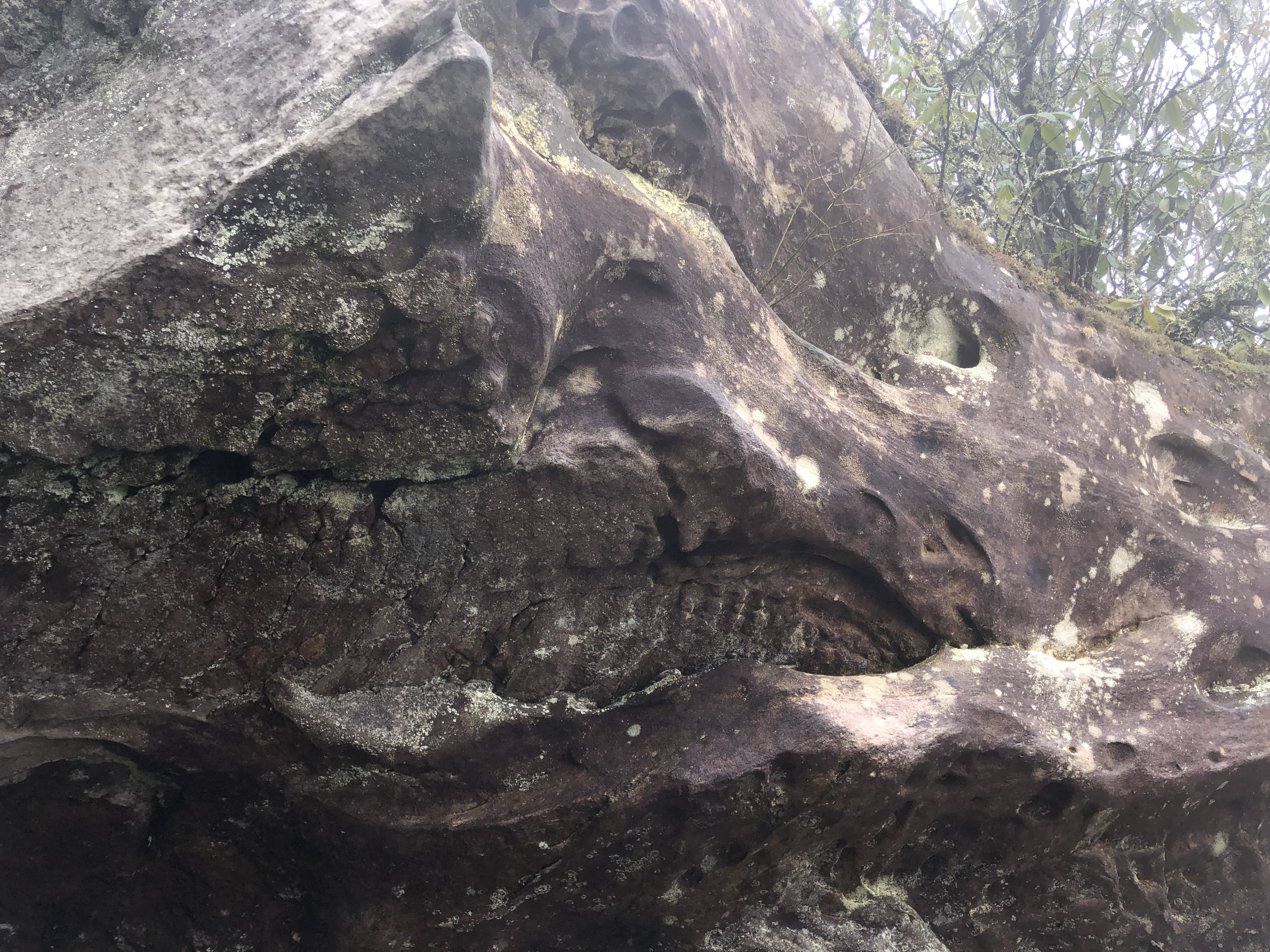
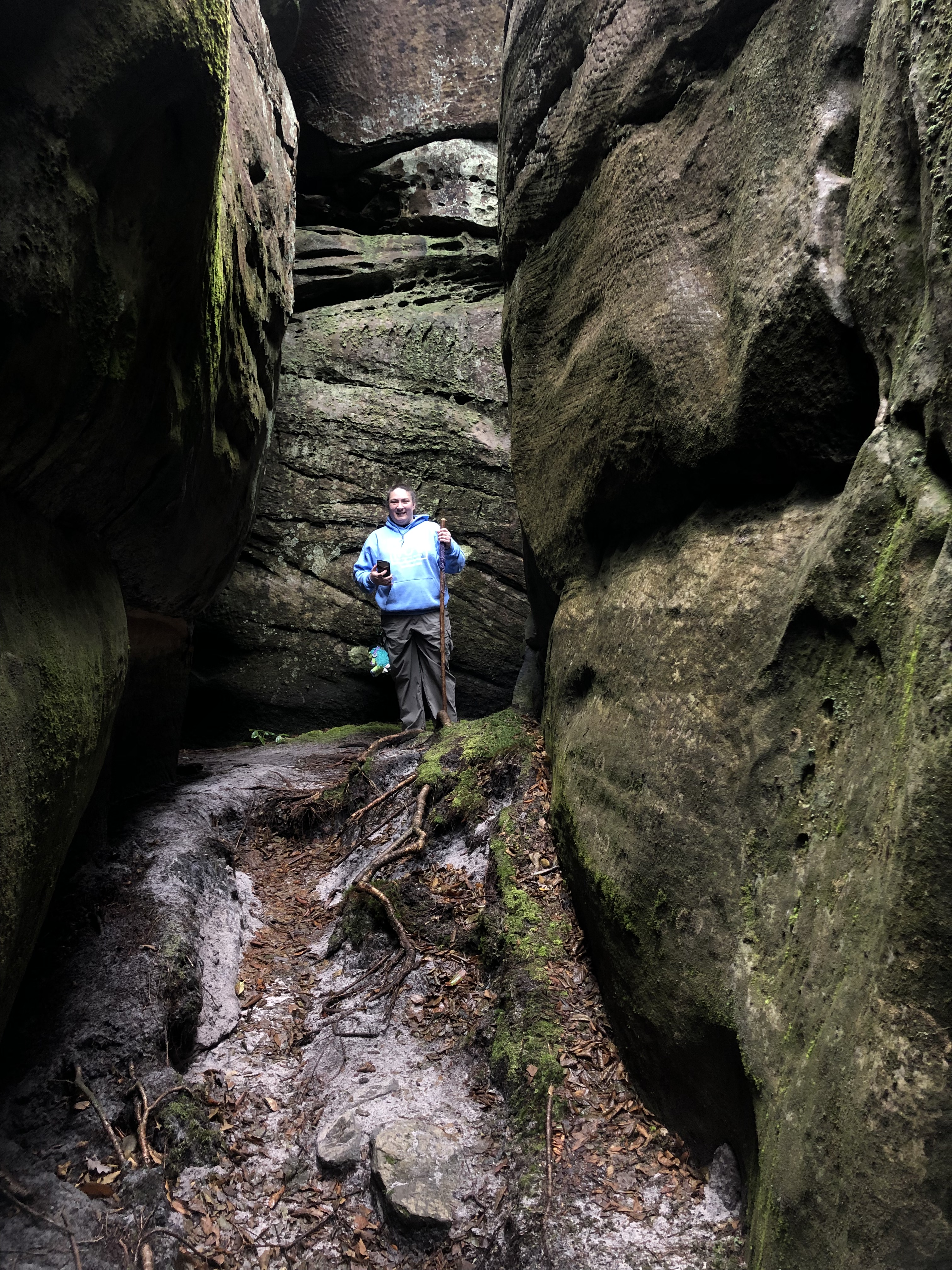
fter hiking a little over three miles, we reached the spur trail that leads up to The Channels. I led the first section of the group up, making certain they found their way to the fire tower where we would have stop for lunch. This path was especially muddy and was a much narrower footpath than what we had been hiking. Along this trail is an interesting rock formation that I think looks like a shark’s head.
I then hiked back down and met the last member of our group and encouraged her as she made the rest of the journey. She stopped off at the rock formation that I had passed earlier, finding a nice place for a rest. I encouraged her to keep moving since she was so close and our destination was even better.

As we reached the fire tower, the top of the mountain was indeed shrouded in clouds. Part of our group ate lunch under the fire tower while others sat on the rocks nearby to eat. The temperature here was cooler than when we started. My tempe device registered 45° and the wind made it feel even cooler. I put my sweatshirt back on and even donned a knit cap to keep my ears warm.
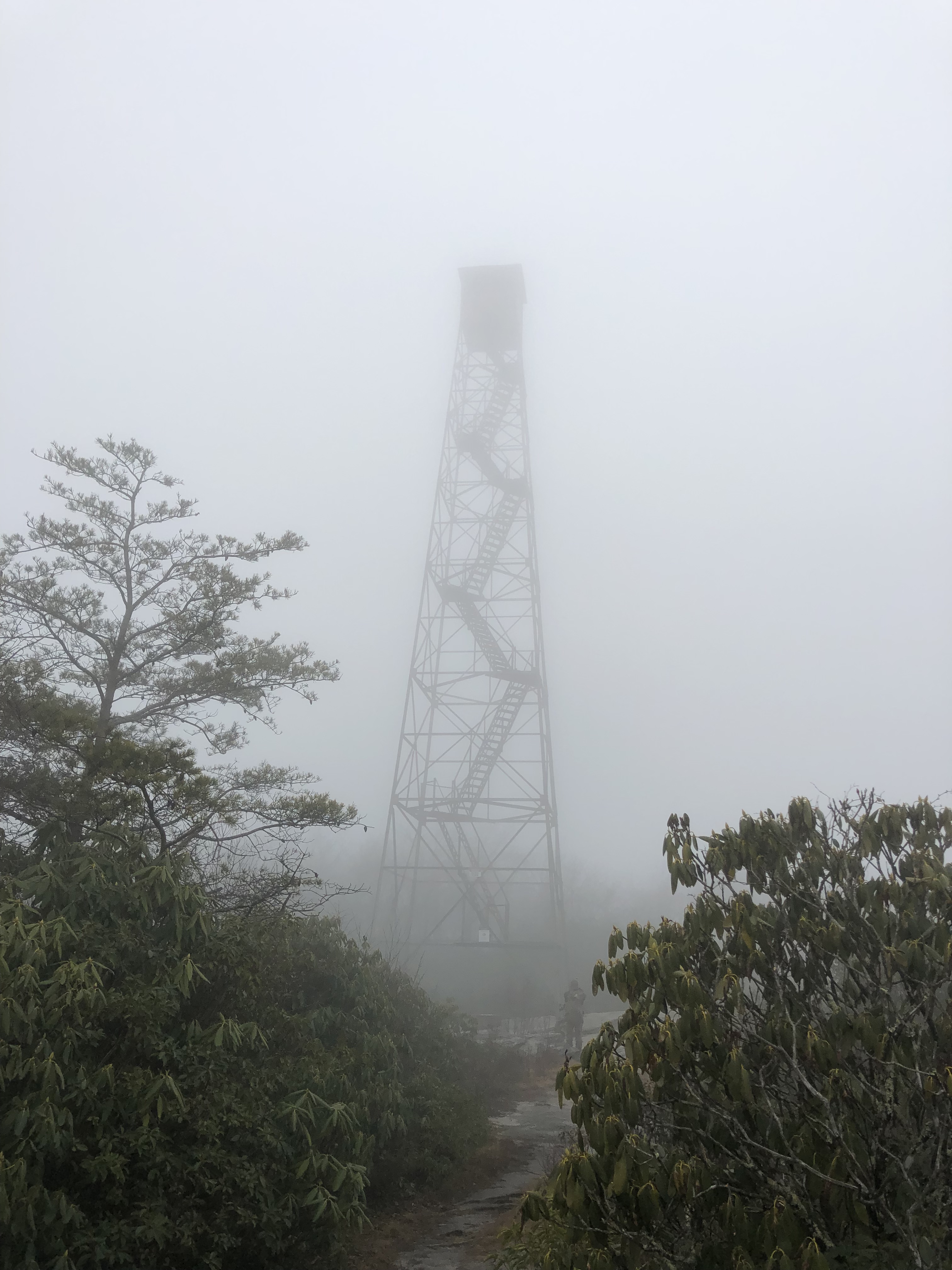
The fire tower is one of the tallest I’ve seen, and I’m sure it offered great views of the surrounding valleys when it was in operation. The lower steps have been removed, and there are signs on it forbidding climbing. I have heard that there were renovation plans discussed several years ago, making it available as an observation tower. Those plans never came to fruition.
After eating, we each made our way down into The Channels at our own pace.
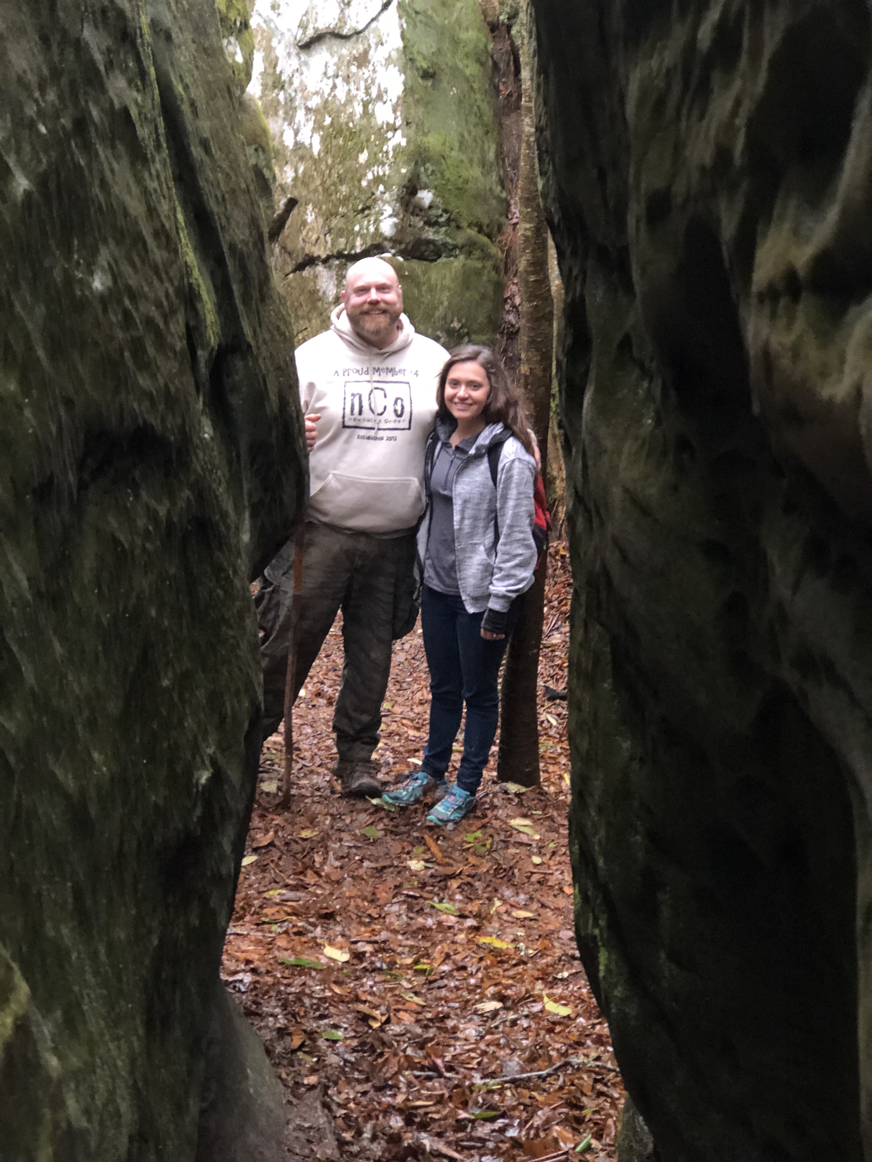
The Channels is a formation of limestone outcroppings. Permafrost and ice wedging 400 million years ago created deep crevices in the rock. Today, these crevices form a maze of pathways amid 20 to 40 foot tall boulders.
Once I had made my way down into The Channels, I shed my backpack and left it on a rock ledge with others that I recognized as belonging to our group. I then spent fifteen to twenty minutes exploring the maze, giddy with excitement, despite the fact I have been there before. Much of that time I was alone, but often would turn a corner to find another member of our group or one of the many other visitors to the attraction.

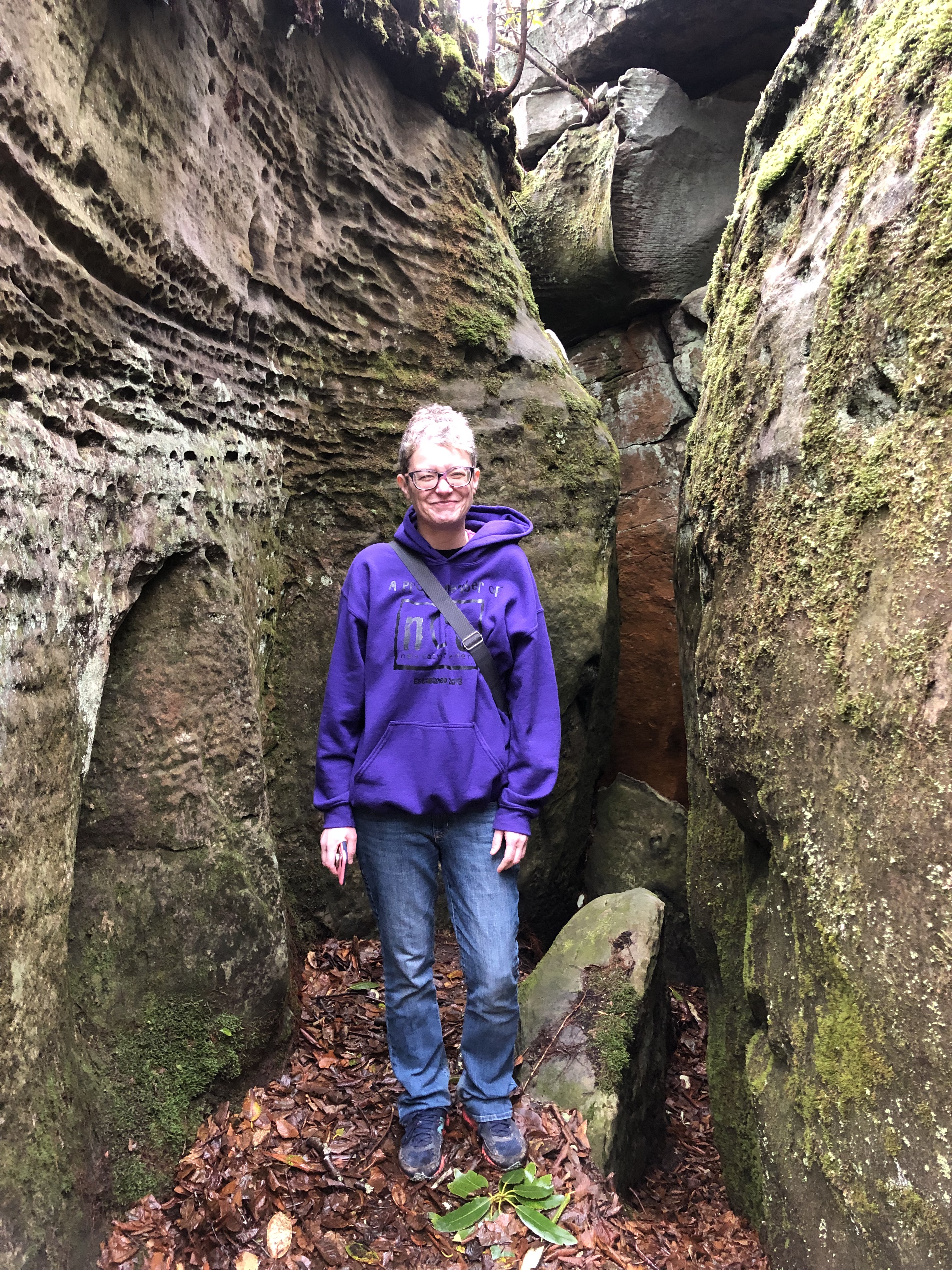
A person could spend hours in this amazing place, taking in all of the sights and exploring each nook and cranny. More adventuresome visitors can climb the rock in places. You can witness the tenaciousness of trees and other vegetation clinging to the rock formations. How they find the nourishment they need to survive is a mystery.

Erosion and weathering has smoothed the rock in some places and created interesting divots and designs in others. In other places you can see boulders that appear to be perched precariously atop other rocks, or wedged in to the crevices. We talked about what might happen if there were an earthquake while we were under one and decided this would be a good plot for a natural disaster film.

In one spot I found a patch of snow still hanging on in the shadows of the rock. I took a picture of it and moved on. It was only later when I had circled back around to this spot that I realized someone had built a tiny snowman here. When I looked back at my photo, I saw that it was there – I just hadn’t seen it. It turned out to be a member of our group that had built it.


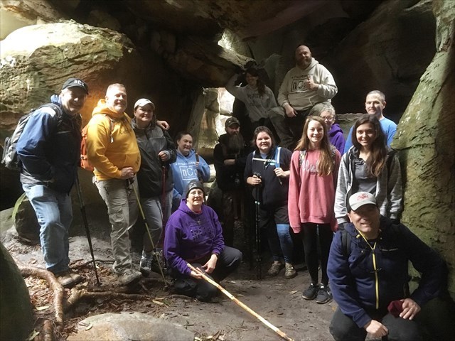
We finally rounded everyone up for a group photo, and asked another visitor to take it for us. By this time, we had been joined by another geocacher who came for the event. She had driven two and a half hours from North Carolina, arriving too late to meet us at the trail head. She made the hike up in an hour and a half, arriving just in time for the group photo.
The two teenagers in our group made a second snowman and put both of them in a plastic baggie to take home. They wanted to see how long it would take for them to melt.

After exploring the area a little longer, we made our way back up to the fire tower. The clouds had burned away by now, so some in the group took the opportunity to take more photos. We then started making our way back down the trail.

The route down was much faster and easier than up. My trip up the mountain had taken 2:25 (not counting the time I took to backtrack and hike the remaining distance with the last of our group). The trip down took me 1:36. I felt that it was at a pretty steady pace, so I really can’t imagine how our latecomer made it up in that length of time. She must have really been hoofing it!
We had passed many groups on our way down, and by the time we reached the parking lot it was packed. One member of our group counted 22 vehicles in the lot, and there were at least three more parked along the road some distance from parking.
While waiting for all of our group to finish the hike, I sat on the tail gate of my truck and devoured everything that was left in my food bag. Hiking makes me hungry!
When everyone was off the trail, some of us decided to make a stop on the way home. Our route took us past Logan Creek Falls, a waterfall I have visited twice before, but always enjoy seeing. It was especially flowing well on this day. We took some photos, and those who hadn’t yet logged the cache here did so.

This was a great way to start the new year. I hope it is just the beginning of many miles to come in 2019.
