Little Stony National Recreation Trail
- 4 miles
- 4:55 duration
- 603 foot elevation loss
- 5 geocaches found
- 6 geocaches visited (previously found)
- 2 EarthCaches visited (previously found)
- 2 DNF (did not find)
For the last few years, I have chosen to “opt outside” on Black Friday. I would much rather be out hiking or doing some other type of outdoor activity than fighting the crowds for deals. Last year, I joined Mrs. Jack (Dori), members of her family and LakeBum (Rob) for a hike at Little Stony Creek in Scott County, Virginia. We only did a portion of the trail that day, and because we had muggles with us we only stopped for three of the geocaches.
I had also returned to this beautiful place in January to see all of the beautiful falls that were frozen after a long stretch of cold weather. I had logged a few more of the caches on the upper part of the trail then, along with the two EarthCaches.
Rob and I decided that this year for Black Friday we would hike all 2.8 miles of this trail, starting at the parking lot above the falls and hiking to the lot near the Hanging Rock Day Use Area. We sent out an invite to the rest of New Cache Order, and were joined by tncorgi (Mary) and Lob the Huntsman (Ray).
We met at the lower trail head at about 10:00 am and discussed our strategy. There was a sign near the trail head alerting us that a portion of the trail was closed. However, while we were standing there a man with several kids returned to the parking area and we talked with him. He said that they had hiked all the way to the falls and had not encountered any problems or trail closures. We decided to go ahead and attempt the hike, reasoning that with a vehicle at each end we could turn back if we came to a closed area or continue on if there were no issues.
We all climbed in my truck and began the drive to the upper trailhead. Because the route by roads is round-about, and largely on gravel forest roads, the trip usually takes about 20-25 minutes. I had just begun thinking that the trip was taking longer than usual when we arrived at a gate across the road. I suddenly realized that we had missed a turn somewhere along the way. Rob pulled up the map on his phone, and directed me as we retraced our route. The directional sign was missing at the intersection where I should have turned, and with all the lively conversation in the truck I had driven right past it. We made a mental note for future trips: “If we pass the log cabin mobile home, we’ve gone too far.”
Back on the right track, we followed another forest road, and stopped at the next turn to look for a geocache. Despite having four sets of eyes searching for it for several minutes we could not find it. The sign at this intersection was missing as well, and according to the hint that is where it had been hidden. We finally gave up and headed on to the trail head so that we could get started on our hike.
Once at the trail head, we all climbed out, donned our backpacks and grabbed our hiking sticks. Rob and I carried our custom sticks crafted by BackWoodsAng, and Mary carried the new set of collapsable sticks she bought from a thru-hiker this summer on the Continental Divide Trail. Ray chose to hike hands-free.
When we had left home earlier that morning, there was still frost on the ground. However, by the time we were ready to hike, the temperature had warmed up to 42 degrees. The eventual high for the day was 50, and we had mostly cloudy skies.
Before heading down the trail, we walked up the road a short distance to the Chief Benge trail head to log a cache there. Have you ever heard the expression, “If it was a snake, it would have bit me.”? Although I was the closest to it, I was the last to see it. It is all about the angle sometimes. If you read my blog post of our hike a few weeks ago on the Lone Oak Trail you will remember that my geocaching mojo was in full swing that day. I was finding one cache after another, including caches that had not been found in two or more years. That was not to be the case on this trip. I couldn’t have found an elephant in a phone booth this day.
After logging the cache, we retraced our steps to the parking area, and set out down the trail. We paused for a few moments to look for the cache at this trail head, one that Rob, Mary and I had all found previously but that Ray needed. Unfortunately, we couldn’t locate it. Ray said that he WOULD be coming back to visit this area again and would get it next time, so we continued down the trail.
A short distance from parking is the first bridge. One real advantage to this hike is the nice bridges that make crossing the creek much more pleasant; especially in cooler weather. According to my research, these massive structures were helicoptered in by the National Forest Service.
Just below this bridge is the first waterfall, a 24 foot high punch bowl type falls. There are several stone steps leading down to the creek below the falls, but they can also be viewed from the trail. We all elected to go down the steps to take in the full beauty of this waterfall. A woman there saw us preparing to take a selfie and offered to take our photo. She and her father were fishing for trout but had not caught anything. Her uncle had made it about 1/3 the way down the steps, and had decided the climb down and back up would be too much so he waited for them there. He chatted with us as we went down and again as we went back up.
This waterfall was one of the two EarthCaches along this trail. I had logged both EarthCaches on a previous trip so didn’t need to collect answers this time. I was able to just enjoy the view and take photos.
After we had climbed the numerous steps back up to the trail, we stopped so that Rob and Ray could find a geocache. Mary and I had found it on our February trip after a very long search. I sent the guys in the right direction, and Rob saw it from several feet away. The previous finder had not hidden it back very well. The log book inside was soaking wet, so the guys signed a fresh log sheet and left it in the cache.
We then moved on down the trail to the second bridge and waterfall. This waterfall is smaller at about 12 to 15 feet high, but reaches across the expanse of the creek. Rob, Mary and I had all found the cache under the bridge, but we paused so that Ray could log it. Rob, Ray and I then went off trail to the creek side to take pictures of the waterfall while Mary waited on the trail. The sun was shining here, making it very difficult to get good photos of the waterfall. Rob asked me to turn down the brightness, but I couldn’t find the dimmer switch.
In addition to the waterfall, we were treated to the sight of a rare Southwest Virginia T-shirt Tree in full bloom, ready for harvest. What? You’ve never heard of that species? This one was growing a very wet, grey t-shirt high in its boughs. I laughed as I thought of kids swimming here in warmer weather, and someone snatching another’s shirt and flinging it into the tree. It was perhaps 20 feet up in a tree with no climbing branches. I guess they should have carried an extension ladder with them. (See my previous blog post if you don’t catch my drift).
When we were getting ready to leave, Rob said, “Betty, are you staying down here?” I told him no, and he gave me a funny look. He said, “Going to the next waterfall from down here?” Again I said no, wondering what his problem was. As he and Ray started climbing the path back up to the trail, I realized: I had missed the path and was wandering aimlessly along the creek looking for it. This was the second time I had gotten lost today, or at least directionally challenged. I told Rob he needed to put me on a short leash.
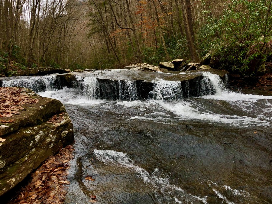
Between this waterfall and the next, we came to a section of trail that had apparently washed out – probably the section that the sign at the trail head referred to. It was still passable if one took great care, and we all made it across safely. We stopped so that Ray could log the next geocache, which was also lying in plain sight. We took photos of the third falls from the trail and the observation deck. This is the biggest waterfall along this trail, a block style fall that is wider than it is tall. Mary and I remembered going to the bottom of it in January when it was frozen. We had taken turns trying to climb onto a low ledge of ice for photos, and then slide off of it.
None of us had found the next two caches on the trail. The first was called Granny’s Water Totin’ Bucket and the largest container of the day. According to the hint, it was hidden about 25 yards off the trail in the vee formed by three large rocks. When we arrived, we were faced with a hillside COVERED in large rocks. The four of us spread out over the hillside searching for at least 30 minutes without finding the cache. There were just too many places it could have been. It was last found in October of last year, meaning it is probably hiding beneath two year’s worth of fallen leaves. The thick blanket of leaves made navigating this hillside treacherous. Some were wet and slippery, as Rob can attest. Others hid ankle-twisting holes that made me glad for sturdy hiking boots. We finally gave up and moved on down the trail in search of the next cache.
It was hidden right before the third bridge. I groaned when I read the hint: “behind rock covered with sticks.” Not another one! I saw a likely rock and began digging around in the leaves without finding anything. Rob started digging on the other side, and soon came up with the cache.
We crossed the bridge and soon came to the next waterfall. This one is more of a sliding cascade, but still very pretty. While Ray and Mary looked for a cache that Rob and I had already found, we sat down to have some lunch. When Rob pulled out his leftover Thanksgiving turkey sandwich, he remembered that he had eaten the same thing in the same place last year. I had some leftover ham and rolls from the night before, and I had combined them with some cheese to make my lunch. After finding the cache, Mary and Ray joined us for lunch, and then we continued on down the trail.
The rest of the journey was new territory for everyone but Mary. There were some parts of the trail that required navigating over and through rocks. In other places we had to climb over, under or bushwhack around fallen trees. We even had a little bit of uphill travel which I had not expected since we were hiking downstream.
When we reached the location of the next cache, I checked the hint and once again groaned. It read, “Up behind rock on left. Coveredleaves and sticks.” (sic) Really? Rocks, leaves and sticks in the forest? Gamely, I climbed up behind the nearby rocks and started searching. The rest joined me, and after several minutes we were all starting to feel discouraged again. Rob decided to check logs written by previous finders, and it was good that he did. One mentioned that it was no longer the large container described on the cache page, and that it was now hidden in a hollow tree next to the trail. Rob moved back down to the trail, and immediately found it.
Further down the trail we passed a spot where there were two huge boulders between the trail and the creek. I commented that they were not just house-sized, but they were McMansion-sized. I was amazed by the tenacity of a tree that was growing out of the rock, and wondered how it found enough soil and nutrients to grow there.
It was about this time that my watch vibrated to alert me to a message. I looked at it and saw the words “Battery Low.” This was not good news because my GPS enabled watch is what I use to track our progress on these journeys. I had obviously forgotten to charge it the night before. I hoped that it would hold a charge long enough to finish the hike, but decided that if it didn’t it wouldn’t be the end of the world.
We had one creek crossing without the benefit of a bridge. This was at Star Branch, a stream that tumbles down the mountain and feeds into Stony Creek. There was a nice waterfall above where we crossed, and I could see that there was another below us. We did not have a good view of that one and I wished I could cross Stony Creek in order to see it better.
There were a couple of rocks strategically placed for us to cross over, but it would be an extremely long step, especially for Mary with her shorter legs. She found another rock nearby and handed it to me to place in the water. I dropped it and it wedged itself upright in a fissure so that we could not step on it. In fact, it was in such a position that the water splashed off of it and would just get us wet as we tried to cross. I finally managed to reposition it with my stick so that it no longer launched water at the crossing, but it was still no help in finding solid footing.
Ray came to the rescue, carefully crossing the creek first and then repositioning the rocks so that we could reach them. He offered a hand as I went next, and then both he and Rob assisted Mary across. Rob followed, and we were all safely on the other side without getting wet. While Mary and I are pretty self-sufficient, it is sometimes nice to have a hand and we appreciate the gentlemen we hike with who will offer that when needed.
When we reached the fourth bridge of our trip, we knew there was another cache to be found just off the far end. Once again, Rob spotted a tiny corner of it from the trail, and had it in hand before the rest of us had even stepped off the bridge. This was definitely his day to find caches.
The next cache was .7 mile further down the trail. By this time we were all growing somewhat tired, but were still enjoying the beauty of the trail. All along the trail, the creek kept offering us one beautiful view after another. Many times we stopped to take photos of the scenery. Often, there were obvious spots where others had done the same. Rock outcroppings gave us a good position for photos in some places. In others we had to be a little more adventuresome, making our way down to the creek to capture a photo. Yet other scenes we just had to capture with the lens of our eyes and memory of our brains because there was no safe way to photograph them.
At one point, the trail was high above the creek, and we could see a unique area of cascades below us. Rob and I both plunged downhill in separate places to make our way to it. While not the impressive falls you can see on other sections of the creek, this was an awesome spot with two foot high cascades free-falling over shelf rocks. I can’t even describe the beauty, but you will find some photos of it below. We could have stayed there all day, but still had trail before us to hike.
Finally, we came to the fifth bridge, and the location of our last geocache for the hike. This bridge was higher than most, requiring us to climb several steps to reach and cross it. A large tree had fallen across it and we had to duck under it to cross the bridge. Mary and I took turns posing for the camera, pretending to try to lift it off the bridge. It was much too heavy to for us to actually do so, but it was fun trying.
In the meantime, the guys had already crossed the bridge and climbed atop another large boulder in search of the cache. By the time I had climbed part of the way up, Ray had uncovered the metal ammo can. After taking their photo I joined them at the top and we explored its contents and signed the log.
From this point we had about .25 mile hike to the end of the trail. The rest of the trip was uneventful. We were very happy to spot Mary’s car and Ray’s truck through the trees and know we were almost done. When we reached parking I checked my watch and found that I had 1% battery power left. I turned off Bluetooth to save power, and it actually lasted until I arrived home a couple of hours later. I was able to download the data from it to my phone and save it for future reference.
We said our goodbyes to Ray, and then Mary drove Rob and I back up to the upper trail head to retrieve my truck. Along the way, we stopped at a cemetery so that Rob could log a cache that Mary and I had found before.
On the drive back down the mountain, Rob and I stopped near the lower trail head again to scout the route to another cache. It is a short trip from parking of about 200 feet, but includes crossing the creek on a very sketchy looking bridge and then climbing an extremely steep hillside to an abandoned mine. We knew this was not in the cards today, but wanted to look over the situation so we know what we will face on a future trip.
We had a long, mostly quiet drive home. I can’t say what Rob was thinking, but I was reliving the day and the fun we had. There are several geocaches in the Dungannon area that we had thought about stopping to find, but we decided that we would continue homeward and log them another day, perhaps when we come back to find the cache at the abandoned mine. Daylight was waning, and we knew that we had a chore to do when we got home.
Great friend that he is, Rob had brought with him his appliance dolly. We had ordered a new washer and dryer that will be delivered in a few days, and needed to move the old ones out of the laundry room and to the garage. We wanted to clean the floor beneath them before the news ones arrive.
When we got home, we had the old ones moved in no time. It is great to have good friends who are willing to help with chores like this, and who have the equipment to make the job easier.
This was another great day with great friends. The Little Stony Recreation Trail is a beautiful place. While it is listed on the maps as a 2.8 mile trek, we added to that distance by walking to a cache before beginning the hike and with all of our off-trail ventures to search for caches and take photos. This made our total distance traveled for the day four miles. It was worth every step, and I hope to return here soon and often.


