Pete’s Branch and Margarette Falls
- 1.44 miles/4.2 miles
- 0:51 duration/3:51 duration
- 240 foot elevation gain/1,152 foot elevation gain
- 52F Low/64F High
- 6 geocaches found
- 1 geocache visited (previously found)
- 52F low/65F high
LakeBum (Rob) and I set out on Sunday morning with plans to hike the Pete’s Branch trail in the Horse Creek area of Greene County, Tennessee. We had hiked in Horse Creek in January 2017 during a geocaching event. However, on that day, we hiked to Squibb Creek Falls. We wanted to return to this area to hike to Pete’s Branch Falls and log the four caches along that trail, as well as two more caches up a side trail from Squibb Creek that we had skipped on our previous visit.
It was a beautiful, December morning. The weather was unseasonably warm and the skies partly cloudy. There had been rain several days in the past week, but only a 20% chance of showers on this day. We never saw rain, only occasional clouds and mostly sunny skies.
As we drove into the Horse Creek Park at about 9:15 am, we noticed two trucks parked on the road. Both were in the opposite lane from ours, but were sitting nose to nose. We wondered what they were doing, and I thought perhaps one was having to jump the other off. The driver of the truck that was facing us had left his door open, so I had to slowly squeeze my way past, trying not to get stuck in the ditch.
As we drove past, we noticed that both men were wearing a combo of camouflage and blaze orange, which has always puzzled me. One is to make you blend in with your surroundings while the other is meant to make you visible. Why combine the two?
The men seemed to be looking up into the woods past us. As we drove around the next bend, we encountered several more trucks with men in camo and orange clothing milling about in the road. Many of the trucks had dog boxes on the back, and in the woods we could hear those dogs barking. Apparently, they were on the hunt for bears.
Fortunately, the trail we would be taking was some distance from where they would be, but we were still glad that Rob had worn his blaze orange New Cache Order shirt. I had a blaze orange headband that I put on, and decided that I would stick close to Rob in case the hunters came our way. I also unwrapped the bear bell that is attached to my backpack so that it could jingle as we hiked and alert bears to our presence. No, it isn’t a dinner bell! Its intent is to scare the bears off, although we decided they would have to have very good hearing to notice my anemic little bell. We decided we should talk a lot as we hiked. I have heard of some hikers who will sing to scare off the bears, but I didn’t want Rob to have to endure my singing.
We parked near the trail head, donned our backpacks, and grabbed our trusty hiking sticks. From parking we followed a gravel road along Horse Creek. The creek was flowing high and fast after several days of rain. Along the way we passed the nice wooden bridge that marks the beginning of the Squibb Creek Trail that we had hiked on our previous trip here.
After hiking just .2 mile, we reached the confluence of Squibb Creek and Horse Creek. At this point the road fords Horse Creek. As we studied our options, we could see that crossing the creek was not going to be possible on this high water day. If we had worn water shoes and shorts we could have simply waded across. If we had driven my truck, I could have driven across. However, we were in Deban’s Kia that doesn’t have the clearance of my truck, and the water looked very deep in the middle of the stream.
I walked a little ways upstream looking for places to rock hop while Rob went downstream. I eventually joined him and we admitted defeat. Pete’s Branch was not going to be a possibility for us today. As we discussed our options, I took some photos of the small cascade where Squibb Creek flows into Horse Creek.
We decided to retrace our steps to the beginning of the Squibb Creek Trail follow it for a little ways, and then head up another, smaller creek in search of two caches that we did not attempt to find on our last trip. Others in our group had looked for them, but we were ready to head for the house by the time we reached that point. Sadly, they did not find them and they were last logged as found in December 2015. It was doubtful we would come up with the finds, but we wanted to give it a try.
As we headed up the ramp onto the bridge at the beginning of the trail, both of us slipped on the wet wood. We slowed down and walked much more carefully as we crossed the bridge, and then began following the trail. We crossed two more bridges, and were very careful on them since they were just as slippery and did not have hand rails.
One half mile up the trail we came to the lovely A-frame cabin we had seen on our first trip here. It is posted as private property, but appears to no longer be in use. Next to the cabin is a creek crossing without a bridge. Again, the water was much too high for us to rock hop as we had on our previous trip here. After exploring several options, we sadly turned around to head back down the trail. It wasn’t worth getting our feet wet to continue our search for two caches that were likely missing.
We arrived back at the car 51 minutes after we had started. There was just enough of a cell signal there to pull up other caches in the area and make alternate plans. We decided that we would go to nearby Margarette Falls. I had hiked to these falls in February 2016 with Cache Cracker Jacks (Tom and Dori) and GrandMasterCamp (Johnny). We had found the cache on the trail to the falls, but another cache above the falls was missing. Tom and Dori had returned a couple of months later to replace that one, so we hoped to be able to find it.
As we drove out of the park, we noticed that the hunters and their dogs were gone. We had heard gunshots soon after starting our hike, so wondered if they had found their prey.
Rob was my navigator as we drove to the trail head for Margarette Falls. We stopped along the way to find a cache hidden beside the road. At least we had finally logged a find for the day!
When we reached the trail head we were encouraged to see other vehicles in the parking lot. I couldn’t remember if there were any creek crossings on this hike, but hoped that if other people were choosing this hike today we would be able to reach the falls. A couple with three small children arrived at the same time we did. I told Rob that if kids could make it, so could we!
The first half mile of this hike is along a wide, gravel forest road. It climbs gradually with an elevation gain of only about 100 feet. The trail becomes more narrow at this point, and begins following the West Fork of Dry Creek. It is still a slow, steady climb and the trail is well-maintained. I had forgotten what a pretty creek this is, with countless cascades. It was very full of water, making each spot we saw even more breathtaking.
At about .75 mile we came to the first geocache. It is about 100 feet off the trail, up a hillside. I had not climbed up to it on my previous trip here. Dori and I were chatting and steadily making our way to the waterfall when we realized that Tom and Johnny were no longer with us. We backtracked to find that they had veered off trail to find this geocache. Since they had already found it, we had just stayed on the trail and used the time to take some photos of the beautiful creek.
Today I made the trek up the hillside with Rob to the cache location. I’m glad that I did, because I saw that the guys had not signed my name to the log on that previous trip. I was happy to add my stamp to the log sheet and make it official. While we were at the cache site, we saw the family of five pass by on the trail below. We followed along behind them for a bit when we got back on the trail.
The trail crossed the creek via a very nice bridge from which we could see a long cascade flowing down the mountain. From this point on, the trail becomes much more rugged and steep. There are many areas where you are climbing over or dodging around rocks rather than walking along a dirt path. The creek continued to offer us beautiful views of cascades and small waterfalls. We spotted one area as we climbed that looked especially beautiful, but there did not appear to be a good way to get down to it from our location on the trail. We saw that we could backtrack and then make our way up the creek from a lower point in the trail, but decided to keep going for now. I did climb down the bank at one point to take pictures of another pretty spot.
At about the 1 1/2 mile mark we came to a creek crossing. The young family had just crossed over ahead of us. A couple with a dog was just turning back because they said they didn’t have the appropriate footwear for the crossing. We studied the situation and decided that we could safely rock hop across, staying mostly dry. I went first and made it across with no trouble. Rob sat down on a rock first to tie up his pants legs to keep them dry. He was wearing his knee high water socks, so it looked like he was wearing lederhosen. When I told him that, he said, “Sexy, huh?” He made it across the creek despite the goofy look, and we continued up the trail.
It was just a short distance to the waterfall after the creek crossing. We passed the young family who had stopped so the kids could climb on a big rock. Just before we reached the waterfall, we passed two older couples who were sitting by the trail eating their lunch. I joked with them about not waiting for us to eat, and they said they were too hungry.
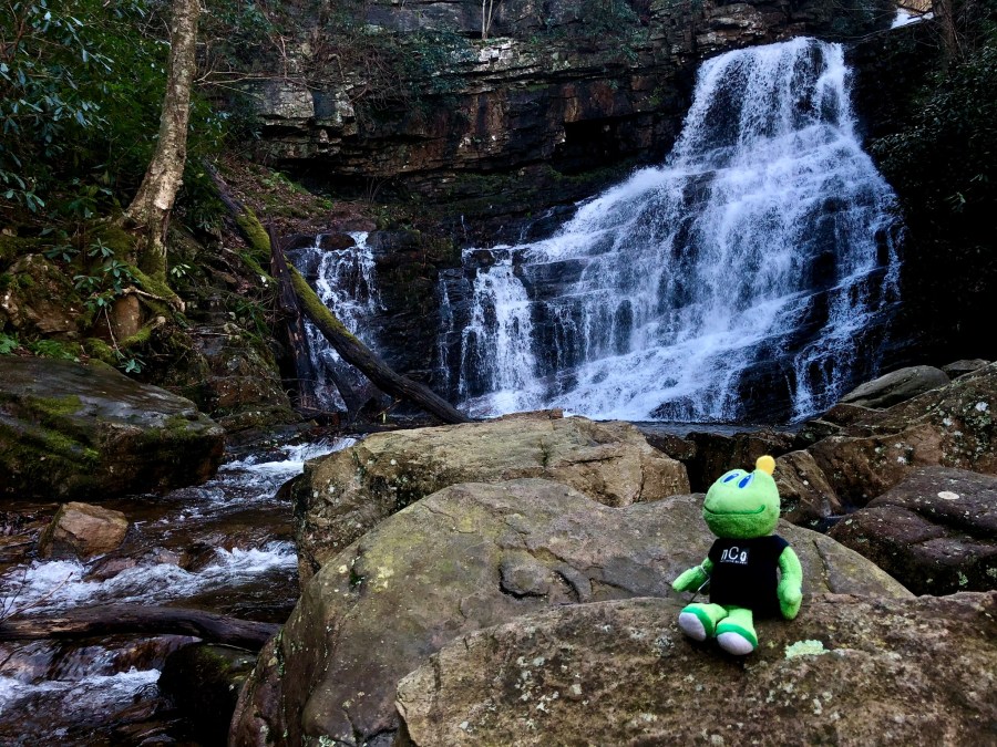
Just around the bend was the waterfall, and it was spectacular. It is reported to be 60 feet tall. It is a wide, fan type of waterfall. The bedrock beneath the water runs in diagonal stripes giving it a unique character. I have seen photos of these falls in dry summer months when there is very little water flowing over them. However, on both of my visits there has been plenty of water, with today’s visit having the most.
The family of five arrived, looked at the falls for maybe two minutes, and then turned to leave. Rob and I just looked at each other and shook our heads. It seemed like a long hike to not stay longer and enjoy the beauty. But, one of the kids appeared to be very unhappy, so I guess he had had enough.
After we had taken in the beauty of the falls and taken a few photos, we found rocks on which to sit and eat our lunch. Rob pointed out that his rock had the perfect butt-sized indention for him to sit on. I remarked that this seemed to be a much more scenic place to eat than that chosen by the two couples we had passed just around the bend. I wondered why they would sit just out of view of the falls to eat than right here at the base.
The longer I sat there, the more I understood their choice. Despite the unseasonably warm day, the temperature was quite a bit cooler this close to the falls. There was a strong breeze coming off of them that made it feel chillier. There was not a wind blowing, so this was simply a breeze created from the force of the water flowing over the rocks. I didn’t let the coolness bother me, and enjoyed my lunch in such a beautiful place.
While we were sitting there, two young women came along. After taking a few pictures, they waded through the water below the falls, and scaled the rocks to the left of them. They sat on a ledge about 3/4 of the way up the falls to eat their lunch. I took some more photos with them on the ledge because they provide some scale showing how large these falls actually are.
After Rob and I had finished eating, we decided to push onward and upward to search for the cache above the falls. We chose the less precarious route up the hillside to the right of the falls. It was very steep and rocky, but there were plenty of roots and trees to grab onto, helping us make the climb.
When we had finally reached the top, we made our way back toward the creek and followed it upstream looking for a place to cross. We could see the location of the cache across the creek, almost within reach, but no clear way to cross to it. The water was running very swiftly and the rocks were slick, making the thought of crossing in the more narrow areas frightening. Especially since just down stream was a 60 foot waterfall that one could be swept over if they fell in.
We battled our way through fallen trees to go a little further upstream where it was wider and the water not so swift. At one point, Rob used his knife to help cut and break small limbs out of our path so that we could push through. We finally reached a point where it looked as if we could safely cross, but the water was about two feet deep in places. We had come this far, and despite our reluctance to hike in soggy boots the rest of the day, our desire to log this cache won out.
We both tied our pants legs up above our knees, and stepped into the stream. I was pleasantly surprised that the water was not ice cold! I had not expected a mountain stream to be so warm in December. We were quickly across the water, albeit with water in our boots, and began looking for the cache.
Unfortunately, since it was replaced by Tom and Dori two years ago it has gone missing again. Both the original container and the replacement were metal ammo cans, hidden on a rock ledge. These containers are very appealing to muggles (non-geocachers) and are just a little too tempting to some folks.
Rob said that he had a pill bottle that we could use to replace the cache for now, and then we would come back at a later date to replace that with something more fitting for this area. This is the type of geocache that needs to stay in play. If it weren’t archived, it could not be replaced because this is a National Forest. Older caches placed here are grandfathered in, but new caches cannot be placed without permission and usually entail paying for a permit.
I said, “But do you have it (the pill bottle) in your pocket, or over there where we left our packs?” Of course it was across the creek in his backpack. He said he would wade back across and get it, put a rock in it to give it a little weight, and throw it across to me.
I waited while he did this. When he had the container ready, he motioned that he would throw it past me, high on the bank. I stood aside while he did this. Naturally, it landed on a rock rather than on a soft bed of moss or thick leaf cover. And, it cracked. I placed it as far under the overhang of rock as possible to stay dry and then started to make my way back across.
A thought had been nagging at me since we climbed past the falls, and I stopped to check my phone to see if I was right. I thought I remembered hearing rumors of a second waterfall above Margarette called Bailey Falls. I had just enough of a cell signal to look it up and found that I had remembered correctly. However, the website I looked up described the trek to it as being a creek walk. I told Rob about it when I reached the other side of the creek, but we decided to save that for another day when the water wasn’t so high.
We carefully made our way back down the steep hill next to the falls, and then began our hike back to parking. We passed several people along the way, and I shared with Rob that I had read this was the most popular waterfall hike in Greene County.
On the way back, we backtracked upstream to take photos of the small waterfall we had seen earlier. This was not as easy as it had looked from the trail, as the terrain was rocky, holey, and covered with leaves and fallen debris. It was worth the effort, though.
When we had arrived back at the car, I told Rob it was up to him to direct us. I would just drive wherever he told me. We both wanted to log a particular cache at a church along the Nolichuckey River, so decided to head in that direction.
But first, we stopped to investigate the possibility of finding a multi cache not far from the trail head. Since this cache was hidden in 2016, it has only been found once. Another cacher logged a note in 2017 to say they saw No Trespassing signs posted on the property. We parked and made our way up a dirt road toward the coordinates. We arrived at a creek that would need to be crossed, but before we attempted that we noticed No Trespassing signs posted on the other side of the creek. That made our decision much easier, and we turned and went back to the car. Rob later logged a “Needs Archived” for the cache since it appears to be on private property.
We then drove a short distance toward a traditional cache. The parking for this cache was at a church, and there were several cars in the parking lot. Since we would have to cross church property to access the cache, we decided to leave this one for a day other than Sunday.
We continued on, with our drive taking us past Mt. Tabor United Methodist Church. I shared with Rob the story of how this church was affected by the tornadoes in April 2011. Not only did the church building incur significant damage, but the small congregation lost three members that night. I had visited this area two days after the storm to check on our churches (I work in the United Methodist district office) and again four months later to see the repairs that had been made.
Our next target was a cache at a convenience store nearby. This cache was missing so we replaced it using a container that Rob had handy. We then went inside to get some refreshments.
We found a cache at another nearby convenience store, but the log sheet in this one was too soggy to sign. I had spare log sheets and baggies in my backpack, so we were able to replace that as well. We then made our way to Ebenezer United Methodist Church to find the cache there.
This is a beautiful little frame church sitting next to the river along a dead end road. Although it is one of the churches in my district, it is one of the few that I had never visited. The cache here had not been found since December 2015. Two cachers had looked for it in 2016 without success. Rob spotted it easily from several feet away, just where the cache page said it would be. We were happy to score this three year cache resurrection.
The cemetery of the church held many very old gravestones. However, it was the two hand-etched stones near the cache that intrigued me. Both were at the bottom of the bank, not up in the cemetery with the rest, and they apparently were for two infant children of the same couple: Mr. and Mrs. W. E. Thompson. One was for a son, Maynard J., and was dated 1903 – 1903. The stone for the daughter, Florance, was dated 1921 – 1921. Such a wide range in dates!
Although it was just a short walk back up the hill to the car, our sore muscles and bones protested the journey. We finally made it with much groaning and complaining. We made one more stop on our drive home, this time at another church in my district, Chuckey United Methodist Church. The cache hidden in the graveyard of this church was missing. It was supposed to be hidden in a hollow tree, but despite reaching in up to my elbow and digging all around in the dirt, leaves and rocks I could not locate it. I did squeal a bit when my fingers encountered something slimy, but I soldiered on with my search. I had noticed a pill bottle in my backpack when I was looking for a log sheet earlier. I used it to replace this cache because the hider is not local and does not seem to be active in the game anymore.
After completing our business here, we decided to call it a day and make our way home. Despite the many obstacles we had faced, we had been flexible enough to change our plans and make it a good day. While we were not able to find all of the caches we had targeted for the day, we will return at a later date to look for them, better prepared for the creek crossings.

Too deep for us to cross 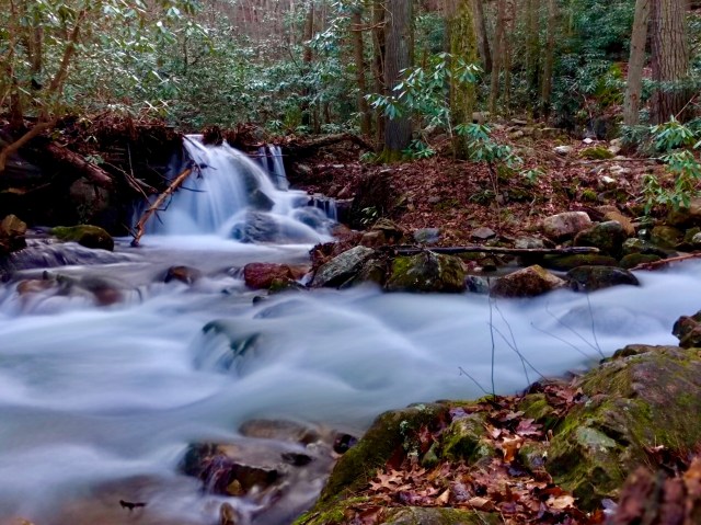
Confluence of Squibb and Horse Creeks 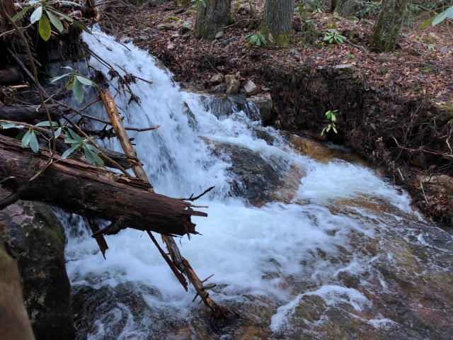
Cascade on West Fork Dry Creek 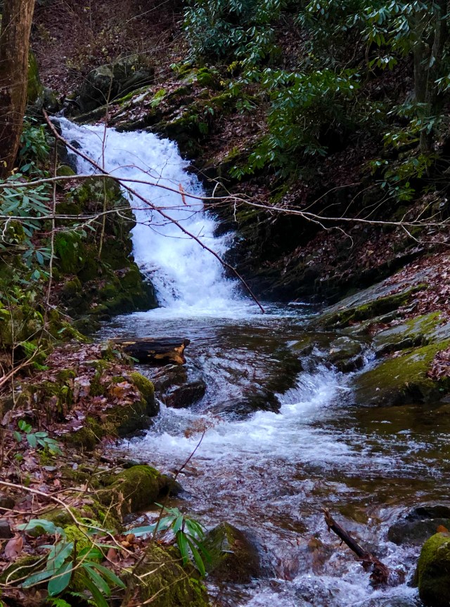
Small waterfall on West Fork Dry Creek 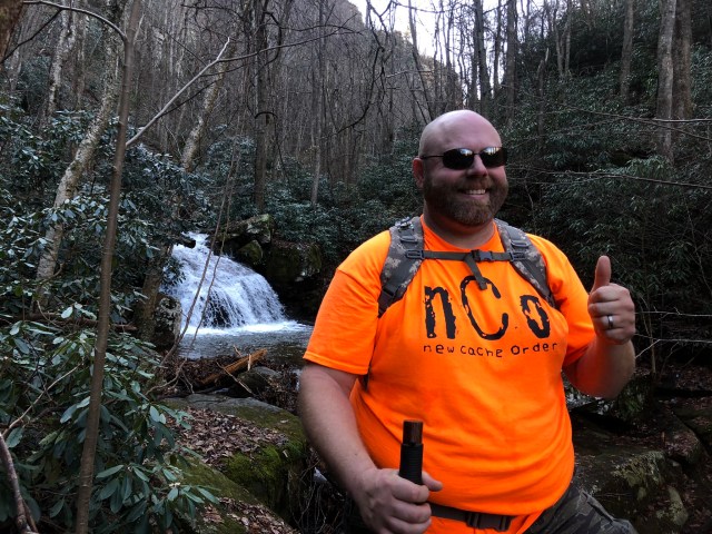
My hiking buddy 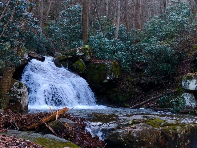
Another pretty cascade 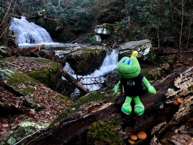
Signal loves water 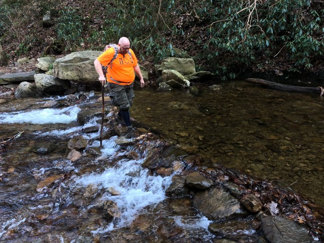
Rob crossing the creek wearing lederhosen 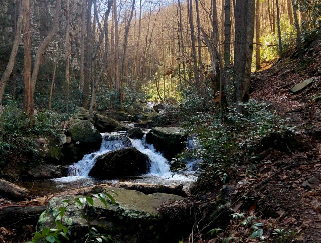
Beautfiul area along the creek 
Signal at Margarette Falls 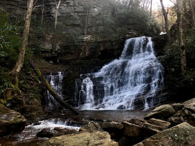
Hikers on the ledge at left give some perspective 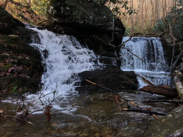
Double cascade 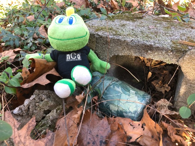
“This is my Ebenezer”. A three year cache resurrection. 
1903 grave stone 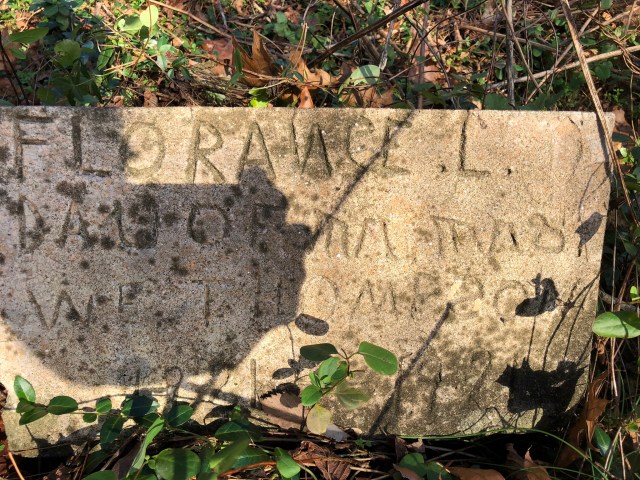
1921 grave stone 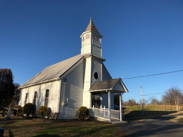
Ebenezer UMC 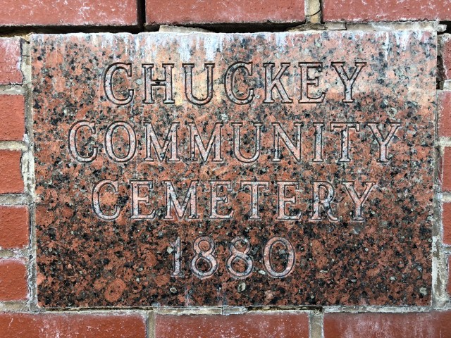
Cemetery sign at Chuckey UMC
