Pinnacle Nature Preserve
- 5.05 miles
- 4:56 duration
- 597 elevation gain
- 5 traditional geocaches found
- 2 earthcaches found
- 1 virtual cache found
- 1 DNF (did not find)
Mrs. Jack (Dori), LakeBum (Rob) and I set out early Saturday morning for a geo-adventure at the Pinnacle Nature Preserve near Honaker, Virginia. This was the first time Rob and I had been there. Dori had hiked there twice with Captain Jack (Tom) but was eager to return.
After an hour and a half drive we arrived at the parking lot with no problems, and began our hike at 10:00 am. A very nice swinging bridge took us from parking across Big Cedar Creek where we logged our first geocache of the day. We then followed the creek along a gravel forest road for a mile to the secondary parking area that is only open at certain times of the year. A second geocache is hidden near this parking area.
Along that service road, we began seeing a strange looking fruit on the ground. It was the size of a grapefruit, but with a bumpy texture that made it look like a green brain. After getting back home I looked it up and learned that it is Osage Orange, aka Hedge Apple or Horse Apple. While technically edible, it is apparently not very tasty. We didn’t try it to see.
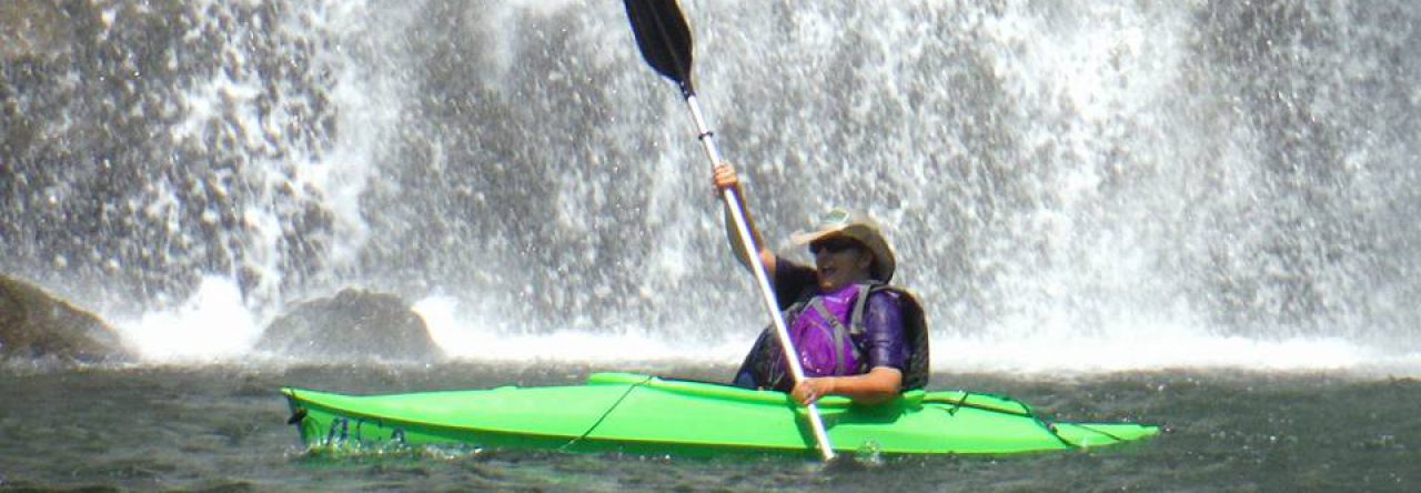
From the secondary parking lot we continued on the Big Cedar Creek Trail to Big Falls. While only 10 to 15 feet tall, these falls are impressive because of the amount of flow and the fact that they stretch across the wide creek. We spent a good bit of time here, taking in the beauty and photographing the falls. I had carried my Nikon camera with me, knowing that I would have the opportunity to visit a new waterfall. However, I did not take my tripod, and I do not yet have a polarizing filter to fit my new camera, so the photos I got were not as good as they could have been.
We then continued down the trail to its end near the confluence of Big Cedar Creek and the Clinch River. It was at this point that we logged our first earthcache, as well as grabbing another traditional cache. We then turned around and headed back up to the trail to the point where it intersects with the Pinnacle View loop trail.
This trail leads to a point next to the creek across from the 400 foot tall Pinnacle that gives the park its name. This column of dolomite was carved out over the years by the creek and groundwater. We stopped here for lunch during which Rob tantalized Dori and I with the fragrance of the homemade chili he had carried along in a thermos. This was also the site of a second earthcache. A little further around the loop we found a sign that gave us the information we needed to claim the earthcache.
At the end of the loop trail was the start of a side trail leading to the Copper Hill overlook. While only a half mile in length, this trail climbs very quickly to the top of the hill with an elevation gain of almost 400 feet, and is rated strenuous. From the top, one has a panoramic view of the Clinch River valley which must have been glorious just a few weeks ago when the fall foliage was at peak color.
We spent a good bit of time at the overlook searching for a geocache. Sadly, we never found it and suspect that it is missing. We finally gave up and headed back down into the valley and back toward the truck.
There was an additional trail that we had considered tackling on the way back, a loop that would take us up another ridge and then back down to the main trail. Another geocache awaited us on the top of that hill. However, we decided we didn’t have the time for that trip today, and saved it for a future date.
We arrived back at the truck nearly five hours after beginning our hike. My feet were screaming by this time, because the boots I bought a few months ago work great on flat and uphill stretches, but cause me pain when hiking downhill because my feet slide forward in them. I am usually able to tie my boots using a special technique to prevent this, but have not been able to perfect that with this pair. I have worn them on four hiking trips so far, and have ended up with sore toes during and after every hike.
Because of my sore feet, I immediately changed into Crocs when we got back to the truck. Rob and I told Dori that the last time I had done that, he had suggested stopping off on the drive home to see another waterfall and log a geocache. The cache was just .10 from parking, but ended up being a much longer hike on a steep trail. Crocs were definitely not the appropriate footwear for that excursion.
I was feeling very proud of myself on the drive out that I was able to remember all of the turns without using GPS. However, I started seeing scenery that didn’t look familiar. Finally, Dori said, “I don’t remember all of this!” I programmed the GPS to take us back home and discovered I had made a wrong turn, so we had to double back about five miles to get back on track.
As I drove, Rob was checking his phone for possible caches along the way. We wanted to find at least one so that we didn’t end the day with a DNF. He pinpointed two along Highway 19 between Lebanon and Abingdon that were close together and looked promising. We stopped, and were able to easily find both, although one of them was down a steep embankment that was hard to navigate, especially in Crocs!
Both of these caches referred to a historical figure John Douglas who was killed in the 1770s before he could reach the nearby fort to warn them of an impending Indian raid. There was a plaque dedicated to him at the first cache site, but it was in a very unusual spot in a ravine between the lanes of traffic. To reach it you had to climb over a guardrail and then make your way down the slope through the overgrowth to a large rock on which he had supposedly stopped to eat when he was killed. The second cache was at a wayside picnic spot named for John Douglas.
After logging the caches, we drove on in to Abingdon where we made a rest stop at a gas station. While Dori and I were inside, Rob was again checking for nearby caches. He reported that there was a rare virtual cache just down the street, and we agreed that we should stop to log it before getting on the interstate.
The virtual cache took us to a home-made water wheel name Noria that was very interesting. It was a great way to end our day of adventure. From there, we had another hour’s drive home, but the distance was worth the fun we had and the beautiful sights we took in.
I hope to make it back to Pinnacle Nature Preserve in the future. I have read that there is a wide variety of wildflowers to be seen there in the spring, and I’m sure it is also beautiful in the fall when the colors are at their peak.


