Clinch River
- 7.6 miles
- 5:49 duration
- 1 geocache found
- 3 geocaches hidden by LakeBum
Today’s float was on a new river for us, a stretch of the Clinch River in Scott County, VA. This trip was organized by Richard, the brother of LakeBum (Rob), who had been told about this stretch of river by a co-worker. Also on the trip were Rob, Karaboo (Kara) and Richard’s daughter, Julia. I was excited to experience some new territory, and to try out Huck’s new “engine” – a brand new Werner paddle I bought the day before at REI.
We left a vehicle at Miller’s Yard, our take out point for the trip. While we were there we left a red ball cap hanging in a tree next to the river so that we could recognize the spot at the end of the float. It would really stink to miss your take out point and have to hoof it back to the vehicle from wherever you end up. This was a hat that had belonged to Rob and Richard’s dad, and they agreed that he would have been proud that it was put to such good use.
At the take out spot, we noticed a nice new-looking welcome sign. It included a map of the river with other access points, as well as a list of access points further downstream with the mileage and estimated float time to each. Rob hid a cache here to make it easier to give directions for future trips. For a geocacher, it is easier to navigate to a geocache than to follow directions like, “Take highway such and such to whatchamacallit road and turn left…”
We then all piled into Rob’s truck and drove to the launch site, a shuttle of about 30 minutes. We would be starting our trip at Burton’s Ford. Sadly, there was not a welcome sign here but it was certainly a popular place. A large group of kayakers was already there preparing to launch, and another group was camping across the river. They had apparently parked on the near side, because they were in the process of shuttling people across a couple at a time. Rob hid a geocache at this spot as well.
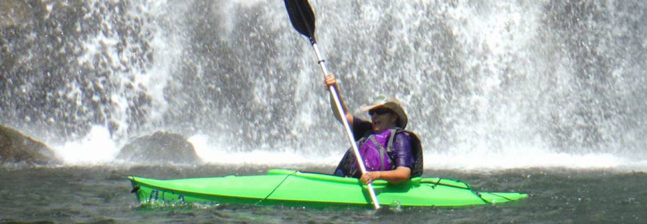
Once we were finally on the river, we traveled only a short distance before pulling into a creek that was feeding into the river. We had been told there was a waterfall there. We almost passed it by since the big group of kayakers we had seen earlier was there, but decided we might as well check to see if it was worth coming back to see. Boy, was it ever!
Named Russell Creek Falls, this beauty was much larger than we expected. I would estimate that the top, wider part of the falls is 30 feet high. This section falls into a pool, and then the water flows through a winding, sliding cataract that is another 30 or so feet long.
I monkeyed my way up the right hand side to the base of the upper falls to take some photos. It was a bright, sunny day, so not the best setting for waterfall photography, and I was just using my cell phone, but I was pleased with how the photos turned out. I will return with my “good” camera next time and hopefully get some real quality shots. From this vantage point I could see an interesting bowl-shaped indentation in the rock next to the chute that looked like a neat place to lounge in the water on a hot day if you are brave (or stupid) enough to climb to it.
When I returned to the creek side where everyone else was waiting, no one seemed to be in a hurry to leave, so I took off to explore the falls from the left hand side. The views there weren’t quite as good without risking life and limb to get close to the edge, so I didn’t spend much time. I thought my companions would surely be impatient to hit the river again.
I once again returned to the creek and met up with the rest of the group at our boats. They were eating lunch, so I pulled out my sandwich and joined them. We spent some time marveling over the surprise this waterfall had been, and sharing pictures we had taken.
Eventually we decide to hit the river again, since we still had many miles before us. While at the waterfall, one of the other kayakers had told us that there was a rapid just downstream that we needed to be careful going through. He advised taking a route down the left side as there is a large rock on the right that has given boaters problems in the past. When we arrived above the rapids we pulled into a calm area and got out of our boats to do some recon and plan our route.
After much discussion and deliberation, we agreed on the best route. Richard decided that he would paddle his boat through first, and then come back to get Julia’s boat. This was one of her first solo trips, so he didn’t feel comfortable sending her through alone. I stayed on the shore below the rapids to shoot video and take pictures of both of his trips through. He learned on his first run that the route we had discussed wasn’t ideal, but had a much smoother ride the second run by altering his line of attack.
I then went up to talk with Rob and Kara while they decided what they were going to do. They decided to try for the second route Richard took. Before they tackled the rapids, Rob and I hid a geocache nearby to mark the spot. I then went back downstream to shoot video of their attempt. They handled their tandem canoe like pros, and then it was my turn to scramble back up the shoreline, climb in Huck, and make my run at it.
I followed the same route as Rob and Kara, making the first drop with ease. I had worried about where to go from there because of the large rocks in the way, but the water took me where it wanted and I made it through without mishap. It was exhilarating and if there had been an easy way to get our boats back upstream, I would have gladly run it again.
We continued downstream, sure that we had encountered the best this river had to offer and prepared for a long paddle to our takeout. We had only gone about two miles in about 2 3/4 hours, so knew we needed to pick up the pace a bit.
Soon we discovered that this river had much more to offer. On the Watauga is a stretch of rapids called the Wave Train. The next set of rapids we encountered on the Clinch was like the Wave Train on steroids, so I dubbed it the Tsunami Train. Huck and I were hit by wave after wave and holes that made it feel like we were on a roller coaster ride. I was very glad that we had our skirt on, because the amount of water washing over Huck’s deck would have swamped us in no time.
This was just the first of several such rapids, which made for a very fun trip. I shot lots of video, and have compiled some of the highlights. You can view that on the New Cache Order channel on YouTube here.
Railroad tracks follow most of this river. At one point we noticed quite a bit of old metal on the bank between the banks and river which made me wonder if there was a derailment here at some point. Another interesting discovery was the remains of a child’s battery operated John Deere tractor hanging high in a tree. This river is not dam controlled like many in our area, and apparently the flood levels can be quite high.
A little over five miles into our trip, we came to the point where the Guest River flows into the Clinch River. We stopped off here to find a geocache that is hidden at the end of the Guest River Gorge trail. It was only 300 feet or so from the river, but required a bit of a bushwhack to reach it. Once again I found myself wading through poison ivy, and hope that washing off my legs in the river will be sufficient to keep me from breaking out. The Guest River offered some more scenic views, and I hope to return here to hike the trail at some point. I have read that it is a beautiful hike along this old railroad bed, with numerous waterfalls along the way.
Eventually, we passed under the remnants of a swinging bridge, and knew that we were nearing our take out point. We kept our eyes peeled for the red hat we had left hanging in a tree hours before, and soon spotted it just where we had left it. We made land and pulled our boats up the steep, muddy bank. Then, Kara, Julia and I settled in to wait the hour it would take Richard and Rob to drive to the launch point to retrieve Rob’s truck and return to the take out point. When they finally returned, we loaded the boats and started the drive back toward Kingsport.
We had all worked up an appetite after spending nearly six hours on the river, so decided to stop off at the Hob Knob in Gate City on the way home. This was my first visit here, and I celebrated our picture perfect day by splurging on a bacon cheeseburger, tater tots, and a peanut butter milkshake.
This is a trip I will long remember, and look forward to repeating some day.


")


Love reading about your adventures. Can you hike to that waterfall or is it only accessed by boat?
Thanks, Alice. Sadly you can only boat to this waterfall as it is surrounded by private property.
Pingback: December 29, 2018 – antbedy