Watauga River
- 10.76 miles
- 4:39 duration
- 3 geocaches found (one FTF)
- 3 geocaches not logged for various reasons
- 1 geocache replaced
Huck and I set off on a Memorial Day adventure with four geocaching friends and their boats. Our goal was to float the beautiful Watauga River in Carter County, Tennessee. Today’s crew dubbed ourselves Team RAM since four of the five of us were driving Ram trucks. And then, there was the one Ford. But we won’t mention who the oddball was driving that truck.
Our group included: LakeBum (Rob), BackWoodsAng (Ang), Got Fossils? (Jerome), Pork n Beans (Jane) and me. Between us we had three kayaks and two canoes. Our plan was to start at the Blevins Road ramp downstream from Elizabethton, TN and end up at the water treatment plant about one mile downstream from the Watuaga Road bridge.
We met at 10:00 am at the take out point. The TVA website reported that there would be no generation at Wilbur Dam during our run, so we were expecting low water levels. When we arrived at the take out point, we saw that the river was running high and fast. Knowing that this would make it a faster run, we decided to extend our trip by a little over four miles and start at the Lover’s Lane ramp, under the US 19E bridge in Elizabethton. I was happy to learn of this change in plans because it would give me the opportunity to find some geocaches that I have not gotten on previous trips.
We loaded the three kayaks up in the two trucks that were already carrying canoes, and headed up to the launch point. It was a little before 11:00 am when we finally got our boats wet and began the trip downstream. The current was indeed fast, and the water level much higher than I’ve experienced on this stretch of the river. I knew we were in for a wild ride, and was glad to be sitting in my trusty Huck, with a spray skirt to keep water out of the cockpit.
A short distance downstream, I pulled over to the left shoreline to grab the first cache that I had on my to-do list. This was one hidden by Rob that the rest of the group had already logged. I spotted it quickly, hanging in a tree, surrounded by a very healthy crop of poison ivy. Seeing no way to reach it without exposing large amounts of skin to the PI oils, I decided to pass on by and leave that cache for another day, perhaps a day when I was not in shorts and a sleeveless top.
When we reached Sycamore Shoals, Rob announced that he was going down the right side of the island, something one cannot do when the water is low. The rest of us followed him gamely, and had a splashing good ride through this challenging rapid. At the lower end of the island, where the two channels are reunited, I got a bit tippy with the new direction of flow, but was able to keep Huck upright and escaped unscathed.
I had the opportunity to stretch my legs after the shoals by getting out of the boat and retrieving a geocache on a small island. Once again, poison ivy was in abundance. I had to wade through a good bit of it to reach the cache, so I made certain I splashed my legs thoroughly before climbing back in the boat. I’m hopeful it was enough to keep the rash away.
We then traveled through a series of shelves that run diagonally across the river. When the water is lower, you must carefully pick your route to avoid the rocks. Today, the rocks were almost completely covered and it was an easy journey.
The last of these shelves typically requires the paddler to navigate over a drop of about five feet. I’ve seen experienced paddlers capsize here, and last year witnessed a friend getting stuck atop the drop off when she missed the chute. That made for an entertaining video which you can view here. Today, with the high water levels, this drop was more like five inches instead of five feet, and everyone made it over safely.
While the others went on downstream, I once again stopped to grab a cache I had never logged. This one required an upstream paddle alongside the falls we had just come across, and initially I overshot it, paddling too far upstream. I checked the coordinates, realized my mistake, and floated back down a little ways until I saw the cache hanging in a tree. Once again, I was prevented from logging this cache because I could not unscrew the lid, so had to leave it for another trip.
I paddled on down to meet the rest of the group, and we went together in search of another cache recently hidden by Ang that had not yet been found. This one was easily reached by Rob from the comfort of his canoe, and we celebrated a blank log sheet and the knowledge that we were First to Find this cache.
From here, it was a quick paddle down to the Blevins Road ramp where we had originally planned to launch. Instead, we made this our lunch spot, pulling in to enjoy a picnic on the grass while watching fishermen futilely casting their lines. It was only after we had stopped that I realized I had sped past another cache I had intended to find. It will also have to wait for another trip.
Over the next four miles of this river are several more fun rapids, made even more exciting by the high water volume. This stretch of river also boasts some very scenic views of high, rocky bluffs, forests, farmland, wildflowers, waterfowl, rustic bridges, rental cabins, bamboo, and sandy beaches. I discovered a small waterfall I haven’t noticed before which I’ve dubbed Cowpie Falls because of the lovely odor of the water flowing over it.
We also stopped for a cache that three of us had not yet logged, and I entertained the troops by making a very graceful exit from my boat in order to take a pen to Jerome so that he could sign the log. Somehow, I made it out of the boat and then back in without capsizing, but I am thankful no video cameras were pointed my way. I also encountered another huge patch of poison ivy here, some of which was all up in my face. I will count myself truly fortunate if I don’t experience a break out in the next few days.
Along this stretch of river were two geocaches that I had hidden last year. Rob had told me that on a recent trip he did not see one of these caches that I had hung from a tree, so I had brought along a replacement just in case. That cache was indeed missing, along with the paracord that it was hung with, so I put a new container in place. Jerome helped out by providing cord to secure it to the bottom of the tree out of sight. Ang scoured the island for rocks that I could use to weigh it down and camouflage it.
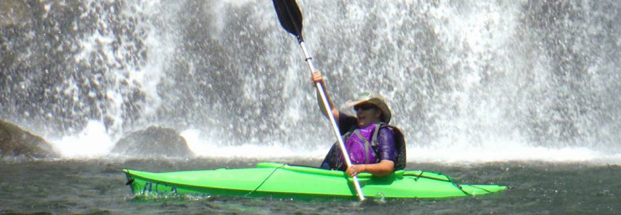
The last leg of our journey took us past one of my favorite spots on this river, Quarry Falls. Some in our group call this Rainbow Falls because if you are in just the right spot on a sunny day you can see a rainbow around you at the bottom of the falls. Despite the name, it is a beautiful spot. The brave (or crazy) boater can paddle right up to and under the waterfall. Already wet from my journey through the many rapids upstream, I couldn’t resist the opportunity to paddle in for a free shower massage.
We made one more stop after the falls, so that Ang and Jane could log a cache I had previously found, and soon we were at our take out spot. I was elected to carry Rob’s canoe back to the launch point in my truck, and Jane hauled Jerome’s. We all made our way back there, and had a photo session with our four impressive Ram trucks before going our separate ways. We also celebrated our obviously superior paddling skills that brought us through all of today’s challenging rapids without a single turnover. You can see video highlights of the trip here.


")

