Bays Mountain Park
- 4.75 miles
- 3:03 duration
- 739 foot elevation gain
- 3 geocaches found
I met up with LakeBum (Rob) and Mrs. Steelers (Melissa) for a beautiful Saturday morning hike at Bays Mountain Park. Our goal for today was to hike the Cherry Knobs Trail to find some geocaches that were hidden this summer. At least, that was the goal for Rob and me. Since Melissa doesn’t care about geocaching, her goal was to just get out and hike.
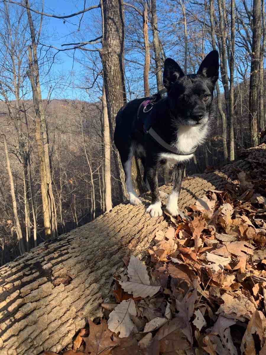
I had once again brought my geopup Andy along. He loves getting out in nature as much as we do. The four of us headed across the dam to begin our hike a little after 9:00 am.
It was a beautiful day with temps around 45°. When we started there was no wind and the skies were a vibrant blue dotted with a few white, puffy clouds.
Once across the dam we hiked along Lake Road for one mile. This is a mostly flat, wide trail of dirt and some gravel. It is wide enough for vehicles but is gated so only official vehicles can access it. Since this is such a gentle trek, we made great time along it.
It was wide enough for us to walk abreast of each other, but eventually I had to drop back a few feet with Andy. He was getting spooked by the sounds of our journey – three sets of feet stomping through the leaves, kicking up rocks and fallen branches. He was constantly jumping and shying away at some sight or sound. Once I fell back a bit he was more focused on keeping up with the others and not as skittish.
Eventually Lake Road begins to climb just a little and we reached Ledbetter Gap. At this point you can continue to the right up Lake Road, continue forward down into Front Hollow, or turn left to go up Bay’s Ridge Road.
We stopped here to take a breather and so that I could shed my hoodie. Under it I was wearing a long sleeve t-shirt. The brisk hike along level terrain had warmed me up and I was already sweating a bit despite the cool temperature. I knew that I would only grow warmer as we headed uphill. Rob also removed his sweatshirt, electing to hike in short sleeves the rest of the day. Melissa kept her hoodie on all day. She is thinner and much more fit than we are.
After a brief rest we headed up the steeper section of Lake Road. Over the next .4 mile the road climbs about 100 feet. Melissa made the climb fairly quickly with Rob lagging behind her a bit and stopping now and then to catch his breath. Although Andy would have gladly run up the hill ahead of everyone, he was tethered to the old woman who was bringing up the rear.

I plodded along, one foot in front of the other, also stopping to let my breathing and heart rate slow before starting again. At one point I managed to pass Rob as he rested, determined to not be the last one up the hill.

At some point Rob and I both passed Melissa. I think she had stopped to take pictures. Ahead I could see a trail sign and Rob said, “There is Cherry Knobs.” I was happy to reach the trail, but knew there was much more to come.

Cherry Knobs is a trail I never really intended to hike. I had done one section of it a couple of times – from Lake Road down to Lakeside Trail. That section is very steep and rugged, but at least I was hiking downhill both times.
The .6 mile section we would hike today goes in the opposite direction from Lake Road to Cross Ridges Trail. I had been told it was extremely rough with a lot of steep ups and downs. Rob mentioned that the last time he hiked it he actually lost the trail for a bit. It isn’t traveled very often, and isn’t maintained as well as some of the others.
As we stood there resting and contemplating what was ahead of us, a quartet of trail runners went by. They had come up Lake Road from the other direction and were heading down the way we had just come. The only thing crazier than someone who runs is someone who runs on steep trails like this. One of the men had legs so skinny that they looked as if they could snap in half at any moment.
Eventually, we continued on our way along Cherry Knobs. The trail was definitely less defined than what we had been hiking and almost immediately we encountered a fallen tree that we had to cross. Rob led the way, depending on occasional blazes attached to trees to guide him. At first it followed the ridge we were on with slight elevation changes. But then it started down.
Over the next .15 mile the trail dropped 60 feet in elevation. Because it was covered with a thick layer of leaves and acorns, the footing was treacherous. I let Andy off leash so I wouldn’t have the extra danger of tripping over or falling on top of him.
Melissa took parts of the descent on all fours, crab-walking down with her hands behind her. I tried staying on my feet, but eventually slipped and landed on my butt. Fortunately, it was so steep that my butt didn’t have far to go to reach the ground, and it was just liking taking a quick seat. Since I was already down, I slid along on my butt a little ways until reaching less steep terrain.
Not quite to the lowest point of the trail, we neared the first cache that was on our agenda. Rob pulled out his phone and announced, “It is 50 feet that way,” pointing further down the trail. The hint read “5’ off trail, base of large tree under rock.” As Rob headed down the trail I looked to my right at a large tree. My spidey-senses started tingling and I circled around it to look. At the base I saw a suspicious-looking pile of slate.
“Found it!” I called out, glad that I hadn’t just walked on by trusting Rob’s phone. That would have meant climbing back uphill to reach the cache. I signed our names to the log and we continued on.

The trail continued to descend, and then we began a steep climb to the top of the next ridge. Or, I suppose since this is the Cherry Knobs Trail it was a steep climb to the top of the next knob. As we climbed my watch buzzed to alert me of another mile hiked, and I called out, “That’s mile two!” Rob stopped, turned and said, “What?!” in an incredulous tone of voice. I said, “We have hiked two miles.” He replied, “I thought you said, ‘I smell poo’ and I wondered why you were sharing that.”
At the top of the knob we stopped to rest. As we stood there talking, Andy suddenly came to attention, staring off into the woods. He growled quietly, making us wonder what he had seen or heard. We could not spot anything around us, but listening intently I heard a rustling in the leaves nearby. “Probably a squirrel,” said Rob. I put Andy back on his leash so he wouldn’t go running after whatever it was.

My legs felt like jelly from all the steep terrain, both up and down. I pulled out my phone to text our friends BackWoodsAng (Ang) and The Captain (Tom). I wanted to make certain they knew how much I hated them for hiding a cache out here and making me hike this trail. Theirs was the cache we had just found. My phone wouldn’t cooperate. Even though I had a strong signal, I didn’t seem to have access to data so I had to leave the text unsent.
Rob was checking his phone to see how far we were from the next cache when I heard a noise behind us. I looked back to see a man hiking up the trail from the direction we had just come. He did not look particularly fit, but seemed to be making the climb without too much trouble.
I had just called out a hello when Rob said, “Pete!” They had a mini reunion on the trail and Rob introduced us to him. We all thought it unusual that we would run into someone else – especially someone Rob knew and hadn’t seen in years – on such a rarely traveled trail. We chatted about the route we were taking, and Pete casually shared that he was doing “about 12 miles” today. He is obviously more fit than he looks.
He headed on and we followed soon after. Just as we had started hiking again we heard rustling in the leaves and looked off-trail about 30 feet to see a wild turkey stalking along. Andy lunged in that direction and I was glad I had put him back on his leash. This was obviously what he had been hearing moments before. I tried to get a picture of the turkey, but it was far enough away and blended in with its surroundings enough that it isn’t visible in the picture.


We followed Rob over the knob and started down slightly. It didn’t seem like we were on the trail but I quickly realized he was looking for the next cache. I had thought this one was also hidden by Ang and Tom, but it was actually hidden by another friend, Reis’s Pieces (Scott). According to the cache page, he hid it while hiking this trail with his mom on her 67th birthday. As a 57 year old I was a bit ashamed to be complaining so much about the difficult trail when someone ten years older had just done it a few months ago.
The hint for Scott’s hide read, “It’s at the base of a cedar tree. There’s really only one at the top.” This hint was not helpful for two reasons. There were at least six cedar trees within sight of the posted coordinates, and the coordinates were not at the top of the hill.
Rob dug in the leaves around at the base of the nearest cedar tree without success. I moved to a nearby tree and half-heartedly dug around it. Thinking about how it was not at the top of the hill, I left to go there and look for a cedar tree. I checked all the cedars nearby without success.
I pulled out my phone and read the hint for myself, and then checked the one “found it” log – written by Ang. He mentioned searching the base of all the trees in the area and finally spotting the yellow cap. As he knelt to retrieve the cache Tom yelled a warning because there was a snake three feet away.
I told the others what I had read and that we just needed to look for the snake. I was kidding of course, but Rob pointed out the obvious fact that the snake was likely not still in the same place months later. As I followed my phone’s compass, it took me back in the direction of the original tree that Rob had looked at.
I decided to re-check the tree I had looked under earlier, and there I found the cache. I grumbled a bit about such a small container being hidden at the base of a non-descript tree in the middle of the woods, but at least I had found it. We also laughed at the fact that a math and science teacher (Scott) couldn’t accurately count the cedar trees and didn’t know the difference between the top and side of a hill.


Once I had signed the log and replaced the cache, we started the tough hike down the other side of this knob. We had just been walking a minute or so when Rob informed us he had no idea where the trail was. Looking all around, we could not see trail markers or any semblance of a trail.
Knowing that Cherry Knobs Trail ends at the intersection with Cross Ridges Trail, I opened the Geocaching app on my phone and pulled up the cache that is hidden at that intersection. I pointed in the direction we needed to go, and we started making our way through the forest across the hillside until we found the trail.
I asked, “What would you do without me today, Rob?” I was rather pleased with myself that I had been the one to find both caches and to get us back on the trail. He answered, “Sit at home all day.” I had no answer to that.
Once on the trail we faced the steepest descent of the day – around 150 feet in .3 mile. Once again I let Andy off-leash for his protection and mine. Melissa cleared some of the trail of leaves by butt-sliding, leaving a better surface for us to walk on. I did a bit of butt-sliding myself on the steepest parts. My knees ached with each step I took. I told Rob that he needed to start hiking ahead of me with a leaf vac to clear the trail for me.
As we neared the bottom, I could hear voices and spotted people. Four men were standing on the Cross Ridges Trail as we approached. I put Andy back on his leash for the last few yards. We chatted with the hikers for a moment and they continued in the direction that we would be going – toward Front Hollow Road.

After they had left, Rob went to check on the cache hidden near this intersection – one of his hides that I had already found. I told my companions I wanted to take a selfie of us. As I opened the camera on my phone and switched to the front facing camera for a selfie, I noticed the brilliant blue sky above me on my screen. I snapped a quick shot, and then gathered Rob and Melissa for another shot.


As soon as I took it I realized we didn’t have Andy in the picture. Rob picked him up so Melissa could take another of all four of us.

After she took it, Rob held Andy a little longer and tried to get some kisses from him. Andy wouldn’t even look at him. Silly dog. He finally gave up, set Andy down, and we turned to hike down the Cross Ridges Trail.

This trail was much more traveled and better maintained than Cherry Knobs. It was also steep, but with better footing since the trail was clearer. We were quickly at the bottom where Cross Ridges meets Front Hollow.
At this point of Front Hollow, the creek has taken over the road and runs along it. It is no longer passable by vehicle, much of it torn up by ATV use and erosion.
Andy was excited to see the creek and immediately walked into it to get a drink. On many occasions I have offered him water when we are hiking, either in my hand or in a small bowl, but he prefers to drink from streams like this. I guess he likes the fresh, mountain water.
I have hiked Front Hollow a handful of times in the past. Every time I do, I remember my first hike on this trail and how I doubted I would ever make it up the hill to Ledbetter Gap. It is still a tough climb, but I am in much better condition to do it now than I was that first time.
Shortly after the three mile mark of our hike I stopped to check my phone and noticed that we were just a little over 100 feet from the third cache on our list for today. As we grew nearer, I spotted it from the trail. Today was definitely my day to find the caches.

After signing the log, we continued up Front Hollow. We had discussed the possibility of backtracking from the cache to Jones Road and following it up to another cache that I needed. I had briefly thought about taking Jones Road all the way up to the top of Bays Ridge so that I could log the EarthCache and one more cache on Bays Ridge Trail that I needed, but decided that we had done enough for today.


Once we reached Ledbetter Gap, we had caught up to the four hikers we saw earlier. We took a break here, happy that the rest of our trip would be downhill. As we rested, the oldest hiker in the other group – a man who appeared to be 80 or so – said to his companions, “Let’s go up this hill.” He pointed to the Bay’s Ridge Road that climbs up to the ridge, and then follows it back down toward the dam.
One of the men said, “You go ahead. My knee hurts and I’m going back to the Nature Center.” The other two men joined the one heading up hill, and they parted ways with the fourth man striking off on his own.
We rested a while longer, and finally headed toward the Nature Center ourselves. Again we took this last mile back to the dam at a fast pace. There was a short downhill at the beginning, and then it was level hiking on a good path from there.
As we approached the dam we saw the man who had split off from his group. He was taking his time crossing the dam, taking pictures all along the way. He told us that he had hurt his ankle recently, and the pain had then moved up into his knee. It had started to get better, but earlier today he had twisted it again.
We crossed the dam and then made the last uphill climb next to the Nature Center to the parking lot. That last little bit of uphill is always a killer!
Since we had not had the chance to eat, and it was now a few minutes after noon, we decided to sit at a picnic table to eat our lunch. I had brought dog food for Andy, but he was not interested in it or anything else we offered him. I enjoyed my warm chili and chatting with Rob and Melissa as we ate.


I was a bit stiff the rest of the day, but felt better the next morning. Hopefully, with a few more hikes I will be back in condition and not so sore afterwards.
