
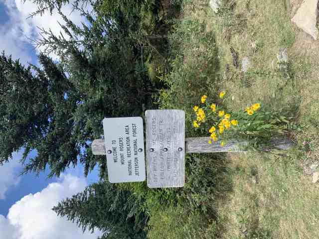
Grayson Highlands State Park
- 5.64 miles
- 4:12 duration
- 962 foot elevation gain
- 1 EarthCache
- 1 traditional cache
I had hoped to do some kayaking on Labor Day weekend, but my usual companions for this activity were otherwise occupied or not feeling well. After lounging around the house all day Sunday, I sent out a message in the Facebook messenger group for nCo Gals (the female members of New Cache Order) asking if anyone wanted to do something fun on Monday.
Melissa, the fairer third of the geocaching team Mandalorian Steelers replied that she would love to go for a hike. Melissa’s husband Larry and son Tristan are the geocachers in the family. Melissa just loves to hike, take pictures and hang out with the New Cache Order gang. Her fellas were working that day, so she was happy to have someone to play with.
She suggested that we go to Grayson Highlands, and I eagerly said yes. This was a place that I had been wanting to visit for quite some time.
I picked Melissa up at 8:00 the next morning and we made the hour and a half drive to Grayson Highlands State Park. The drive took us up Interstate 81, through the quaint town of Damascus, VA and then winding through the mountains of Grayson County.
I had made this drive once before to attend the memorial service of a fellow geocacher. In June 2016 VAtechnoteacher (Michelle) was killed in a tragic accident while riding her mule in Grayson Highlands. Her memorial service was at the headquarters for the area’s Volunteer Rescue Squad that had recovered her body. As we neared the entrance to the park, I began to recognize a few landmarks from that earlier trip.
We drove into the park and stopped off to pay for parking. Since it was a holiday, the parking rate was $10 rather than the usual $7. I regretted having taken a free parking pass for Virginia State Parks out of my wallet a few weeks earlier. It would have come in handy here!
We parked at the Massie Gap trail head and prepared for our hike. There were a lot of vehicles here already, and plenty of people enjoying the beautiful day.
The air was a cool 63°. The skies were mostly clear and a deep blue, with only a few fluffy, white clouds. The hillsides were green, covered with shrubs and low trees.
We descended a short distance from parking, crossing a grassy meadow. The path took us through a gate designed to allow for human traffic but keep the wildlife in. We saw signs saying, “Keep the wildlife wild. Do not pet or feed the ponies.”
This was the reason I wanted to visit this park – the wild ponies! I had heard about them and seen pictures that friends had posted, and hoped that I would be able to see some of them myself. Melissa told me that it was never a guarantee, but that since we were here in the morning we were more likely to see them.
Once through the gate we chose one of the two routes available to take us up to Massie Gap. It was steep going, climbing nearly 200 feet in elevation in the first 13 minutes. I stopped to take a picture as we climbed. Yes, the near landscape and far mountains were beautiful, but it was also an excuse to stop.

I was already feeling a bit fatigued, but wrote it off as a result of my body not fully recovering from my bike ride on Saturday along the Mendota Trail, and an eight mile ride on the stationary bike Sunday evening. All through the day, my legs would complain as we climbed higher and higher along the rough trail. Of course, I have also gained back about thirty pounds in the last couple of years, so that makes a big difference as well.
As the route leveled out at Massie Gap we came to a trail sign showing that our path was joining the Appalachian Trail.

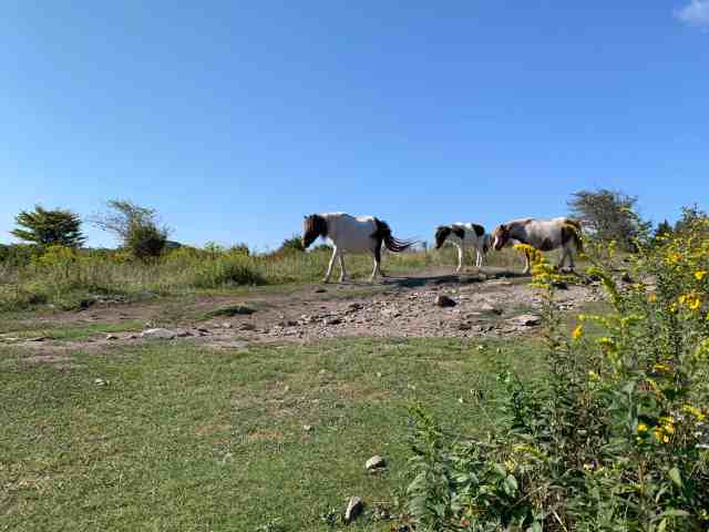
Just past this sign we caught sight of our first pony. We had found them! I was giddy with excitement that I was going to be able to experience the ponies on my first visit here.

We spent quite a bit of time there, basking in the beauty of the day and enjoying the ponies. Several of the mares appeared to be pregnant, and there were already a few foals among them. All of the ponies appeared quite tame and unafraid of the humans. They just minded their own business and munched on the vegetation.

We heard a whinny and looked up to see two mares and a foal walking down the path into the clearing.
Melissa knelt to take a picture of them when they were about 25 feet away. Suddenly, the foal veered off from the direction they were going and walked right up to her. I guess it was ready for its closeup.
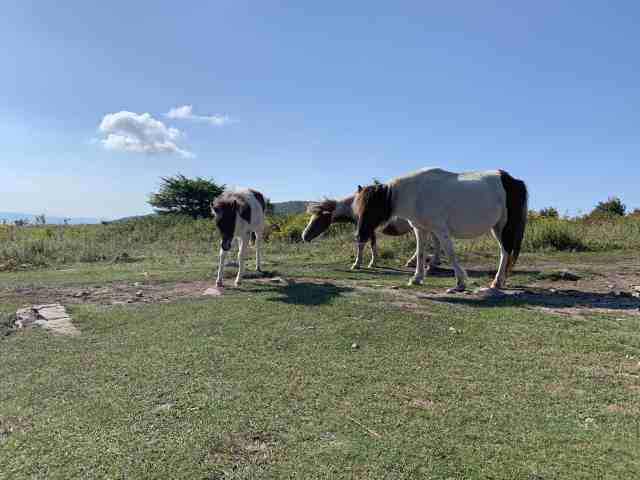

Melissa and I both took dozens of photos of the ponies. A lot of other people were doing the same, and everyone seemed to be very respectful, taking turns posing with them and then moving out of the way so others could do the same. Despite the signs asking visitors to not pet the ponies, many people could not resist doing so. Eventually the foal got tired and laid down to rest, making for some more good photos.

After about 15 or 20 minutes we decided to continue on since we wanted to see more of the park. Along the trail were wildflowers with clumps of tight purple buds. I looked them up on my wildflower app and identified them as a type of gentian.

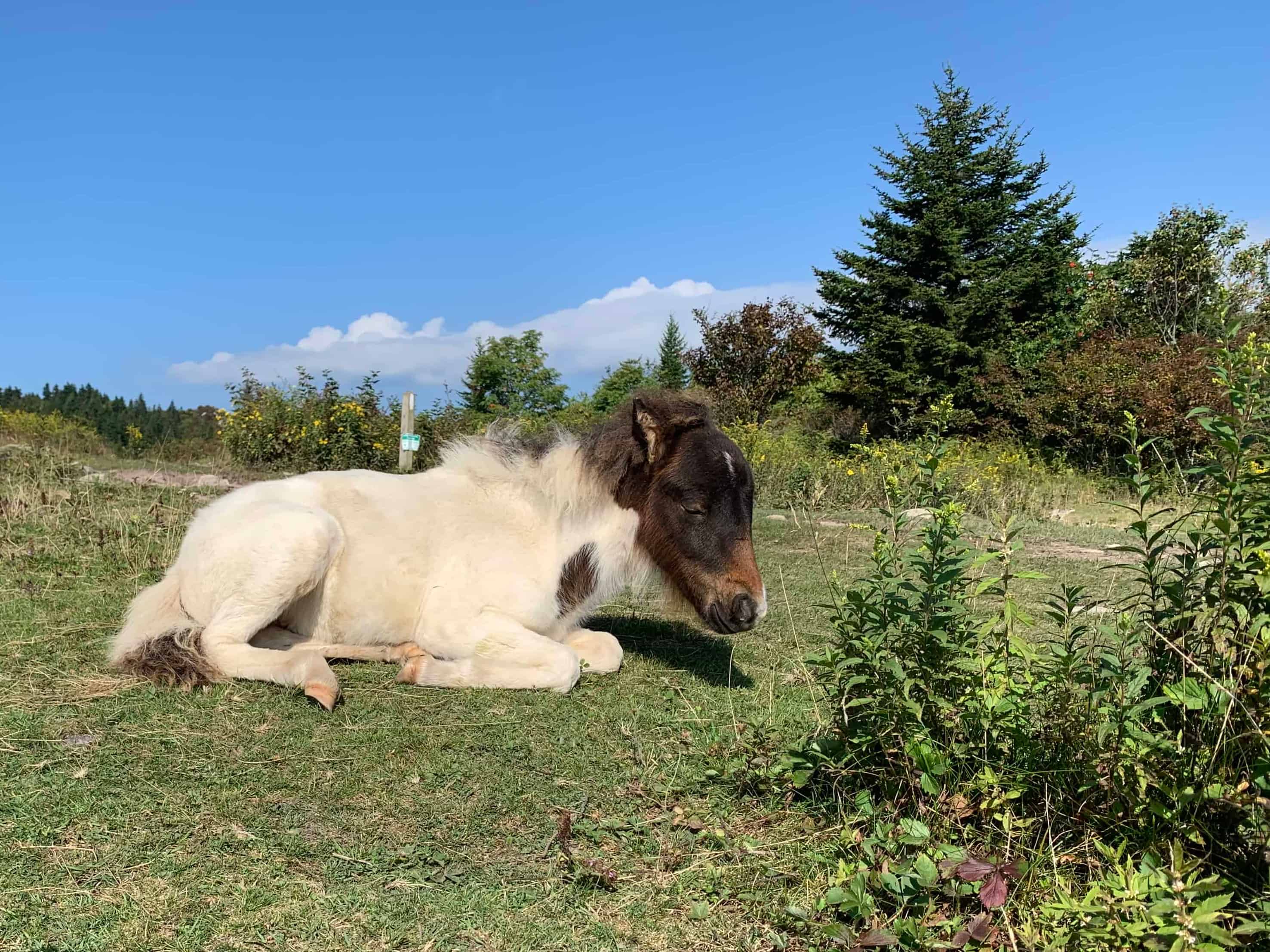
Just a short distance up the trail we saw more ponies walking toward us. This resulted in another stop to take photos of them. One of the foals began nursing as we watched.


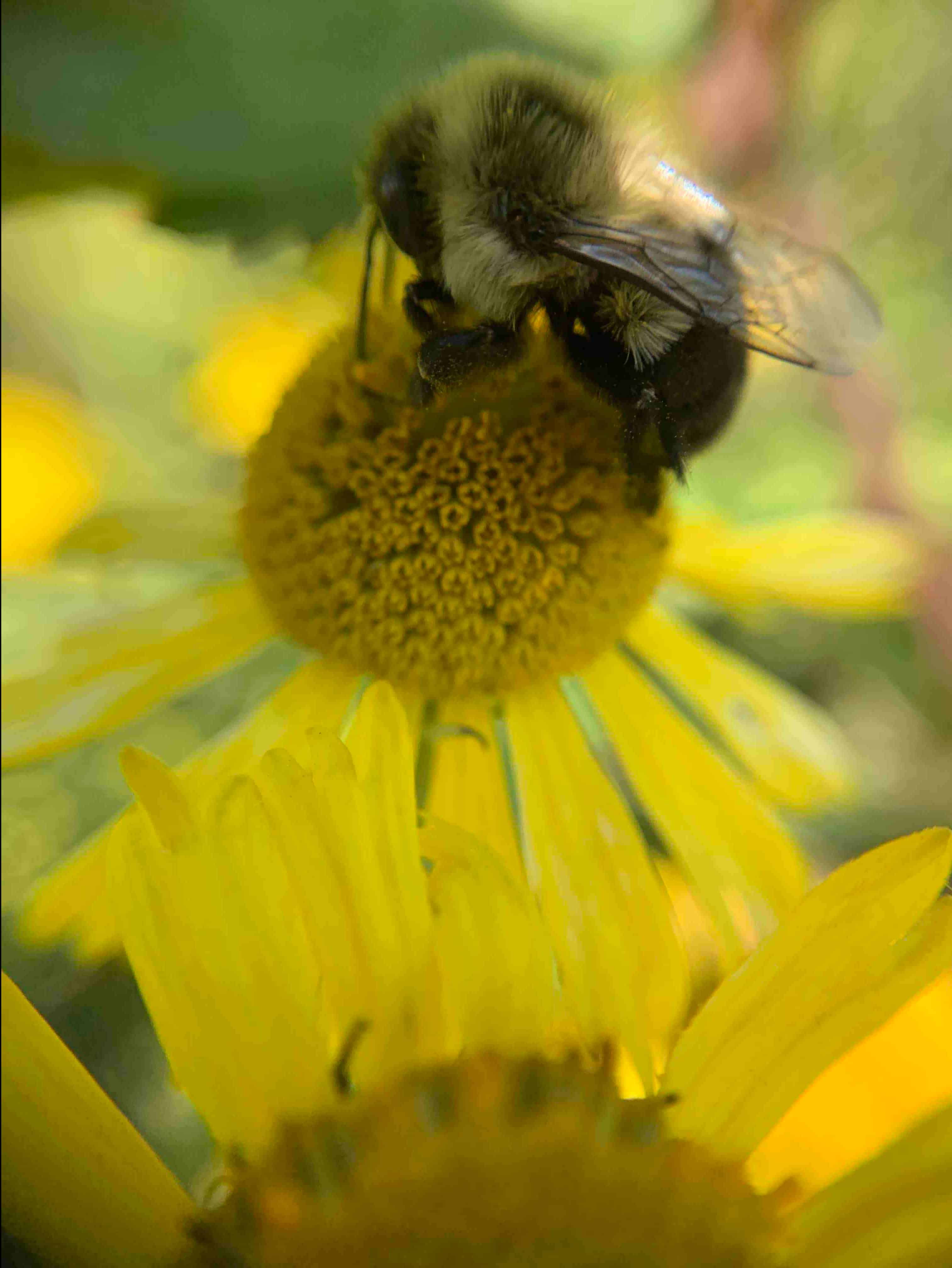
This section of the trail was densely lined with yellow flowers three to five feet tall. They created walls of yellow that we were walking between. I believe that they are common sneezeweed – a type of aster.

We noticed that there were dozens of bees swarming among the flowers and collecting pollen, so stopped to take photos. This is what I love about hiking with Melissa. She stops for as many photo ops as I do, so neither of us feels we are holding the other up.

She has a clip-on micro lens for her cell phone camera, and loaned it to me to try out on my phone. I took a few photos with it that turned out pretty well, but need lots more practice to get it just right. It was really tough to get photos of the bees with the micro lens because you have to get very close to them – just an inch or two away – and they typically zoom off before you can snap the picture.

We discussed where else we would like to go in the park, and I suggested hiking to Rhododendron Rock – the location of an EarthCache. There is also an EarthCache at a waterfall, which we both love, so we decided to try to find it on our way back.
We continued along a fairly level trail for about 10 minutes, and then began to climb again. The views were phenomenal and I continued to drink in the beauty as we hiked. We could see many different hues of green vegetation in the grass, shrubs and trees. Mixed in were more of the yellow flowers. The sky was vibrant blue overhead and lightened in color as we looked to the horizon. White clouds dotted the sky in all directions. In the distance we could see the blue mountain ranges. On the hillside ahead of us we noticed patches of bright red high in some of the trees. We wondered what might be blooming this time of year.

The trail began to climb slightly again, and we stopped at a bench to rest and enjoy the view. Above us the trail continued through another gate. After a short rest we followed the trail through the gate and began to climb again.
We met an older gentleman who was hiking alone. He was headed to Mt. Rogers which was the same direction we were going. I noticed a handheld GPSr attached to the strap of his backpack and asked if he was a geocacher. He said he just gets lost easily, and that he actually had three GPSrs with him! We passed each other on the trail several more times as he would go ahead and then stop to rest, and vice versa.
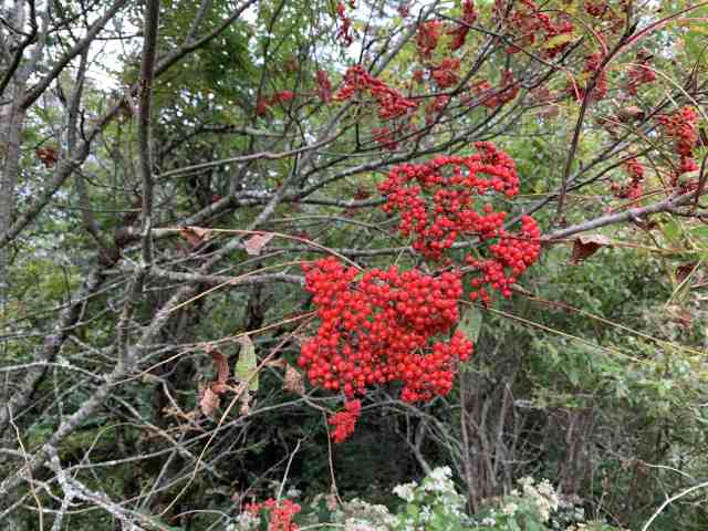
We finally got close enough to the brilliant red that we thought was blossoms in the trees. It turned out to be clusters of berries instead. The leaves of the tree look like locust, but I’ve not been able to find any info on what kind of tree it actually is.

Editors note: I also saw this type of tree along the Blue Ridge Parkway in North Carolina a few weeks later and was able to capture the following photo that betters shows the berries.
Over the next quarter mile the trail continued to climb an additional 175 feet in elevation. Here we reached a fork in the trail and needed to make a decision. Melissa had gone to the left here before, but it looked as if either fork would take us to the same place as the trail rejoined a short distance later.
After climbing another 100 feet in elevation over the next quarter mile, the trail leveled out for a short distance. We came to another intersection of trails where we once again met up with the older gentleman from before, as well as another couple. They were all headed to Mt. Rogers and were trying to decide the best way to get there. Since our goal was Rhododendron Rock, we continued straight at this intersection. They decided this was the best route for them as well.
The trail was pretty rugged at this point, and again steep uphill. At just over two miles from parking we reached Rhododendron Rock, and the highest elevation of our trip. There was still a lot of trail ahead of us, but since this was the location of the EarthCache we were seeking, we stopped here.
We sat down on a large outcropping of rock with Rhododendron Rock behind us and had a well-earned lunch. The views here were beautiful. I pulled up the cache page for the EarthCache to see what kind of information I would need to gather to log it. The first thing I noticed on the page was that this was a “difficult hike”. I didn’t feel so badly about struggling to make it up the trail after reading that.
I also learned that this is called Rhododendron Gap and that the rocks here were formed by volcanic activity. Rhododendron Rock itself is the size of a small house. The view from here was amazing.

As we were eating lunch, many people passed by on the trail going in both directions. At one point, we heard a strange noise and looked at each other. It first sounded like a bear breathing loudly, but we realized it was human. It came closer up the trail, and obviously was a person who was struggling mightily for breath.
Finally, a man came into view, looking as if he might pass out from exhaustion. “Are you okay?” Melissa asked. Between gasps he replied, “They went off and left me; the rest of my group.” “Do you need to stop and rest?” she asked. He decided to pause and try to catch his breath.
He asked where we were from, and then launched into a diatribe about having moved to Virginia a few years ago when the IRS came after him for not paying his taxes for 30 years. “It’s all a scam!” he insisted vehemently. He then told us about a documentary we needed to watch, and how the government came after him when he started showing it to people. He finally continued up the trail, yelling the whole way about the evil of taxes. We just looked at each other and shook our heads.
During our break here, we also saw the older gentleman with all of the GPSrs heading back down the trail. He said that he had decided that wasn’t the way to Mt. Rogers after all and was going to try another route. That is the last time we saw him, so I hope he finally made it to Mt. Rogers and back safely.

We lingered on the rock for a while after eating, laying in the warm sun and enjoying the rest. The temperature had warmed up but was still just in the high 70s, and very comfortable. We finally decided to head back down the trail, and set off for the return trip.


When we reached Massie Gap, there were even more people than before as well as more ponies. We stopped for more photos.

Two little girls were petting one of the foals that was lying in the grass. I heard one say, “It is sooooo cute! Can I have it for my very own?”


After more pony time we continued down off the gap toward the lower gate.

As we approached, I noticed a man on horseback riding toward the gate from the other side. A girl at the gate called out, “Are you my knight in shining armor?” I laughed, thinking she was just flirting, but then realized she was serious. She had injured her ankle and her friends had sent him to take her back to their car. He dismounted, and then helped her climb into the saddle. He then led her toward the parking area.
At this point, we had hiked right at four miles, but it was just 1:00 pm and the day was still young. Rather than returning to our vehicle, we turned west in search of Cabin Creek Falls – the location of another EarthCache.
We found the trailhead for Cabin Creek Trail and began to follow it. This was a heavily shaded trail in dense forest, unlike the balds we had been hiking through all day. The trail was taking us downhill, and we knew that would mean an uphill climb on the return trip. But, we were very close to the falls according to my phone’s GPS so continued on.

After about three tenths of a mile, we came to a fork in the trail. We paused to decide which way to go. I pulled out the trail map I had picked up earlier, and it showed that the trail made a loop from this point, with the waterfall at the very tip of the loop. It seemed we could go either way. There were some young men coming toward us from the right fork, so I asked, “Is that the best way to the waterfall?” “Yes,” one replied. “If you can call it that. It is water and it is falling. That’s about it.” We laughed, and headed up the right fork.
My phone indicated that we were getting closer and closer to the EarthCache, and we could hear water below us to the left. Then, we were past the point my phone was pointing and moving further away. I stopped to check the map again, and then pulled up a photo I had taken earlier of the map posted on a kiosk we had past. That map showed the waterfall was in the center of the loop rather than the very tip, and that it was closer to the left fork than the right. We decided the young man who had not been very impressed with the waterfall had not seen the actual falls.
By this time we had hiked 4.77 miles. According to the map, it would add another mile or so to our journey if we either continued around the loop to the falls, or retraced our steps and took the correct turn. We decided that since we still had the uphill journey to return to the vehicle, we would leave finding the falls for another day.
We turned around and made our way back to parking, arriving at about 2:00 pm. There was a traditional geocache hidden near parking, so we walked over to find it. We then climbed in the truck and headed for home, happy and tired.
There is so much more to see at this park, and I hope to return soon to do more hiking here. I have seen photos of the ponies in the snow, and would love to experience that. And, there are many more geocaches to be found, which is always a bonus!
