
Appalachian Trail – Sam’s Gap
- 3.93 miles
- 2:44 duration
- 889 elevation gain
- 54° low/59° high
- 2 geocaches found before hike
- .5 geocache found during hike
- 5 geocaches found after hike
- 2 geocaches visited (previously found)
- 2 DNF (did not find)
It seems LakeBum (Rob) and I have been on an Appalachian Trail kick lately. This week we decided to head up to Sam’s Gap, which is the point along I-26 where Tennessee and North Carolina meet.
We planned a short hike for this day, because the weather forecast showed a narrow window of opportunity to hike without getting rained on. Our plan was to hike southbound on the AT to grab three caches that were in that direction.
As we drove I-26 toward North Carolina, we decided to make a stop at an overlook near the state line. We had each found one of the caches there in the past. It is an easy park and grab hidden in the guardrail. However, there is another cache hidden at the overlook that is a little more challenging to reach. It is near the bottom of a very steep hillside. When looking back at old online logs for this cache, I noticed that I had logged a note back in May 2014 saying that I had stopped to find the guardrail cache, but had decided to heed the advice in the cache description to not attempt this one alone. I wrote, “I will come back another day with reinforcements.”
It took nearly five years to make it back, but today was to be the day. Both of us had passed by this overlook countless times, but had always been on the way somewhere else or had not been dressed appropriately for such a mission. Since we were in our hiking gear today, and didn’t have a set agenda or time that we had to be somewhere, it was a great time to stop.
I’m sure that the person who pulled up to the parking area at the same time we did, wondered why we climbed out, grabbed our hiking sticks, climbed over the low, rock wall, and headed into the woods. I must say, my journey over the wall was not exactly graceful. It was about waist high, which was too high for me to step up or even “knee-up” like Rob did. Instead, I opted for the “belly-roll” method. I basically laid down on my stomach and then swung my legs across. Not very elegant, but it worked. I’m pretty sure I heard a snort from Rob, but it may have just been his allergies.
When we got to the edge of the woods and looked down, we both groaned. Did I mention it was steep? We began carefully making our way down, using our sticks in one hand to stabilize ourselves, and grabbing at any available shrub, root or tree with the other. Once we were about half way down, our phones’ GPS apps were of little use with the thick tree cover and high slopes. We made our way along, looking at the base of every tree we came to since that was where the hint said it was hidden.
I had started climbing back up to check one group of trees, when Rob called out that he had found it. He was another 30 feet or so lower than I, and graciously offered to sign my name so I wouldn’t have to climb the rest of the way down. I gladly took him up on that offer.

I checked my altimeter while down the hill, and again when I got back to the top. The difference in elevation was 90+ feet. This was a great warm up to our hike.
SPOILER ALERT!
The next couple of paragraphs and photographs describe our hunt for a cache that is very tricky. If you plan to cache in the area of Sam’s Gap and do not want to spoil your fun seeing this cache, quickly scroll down until you see the words in large text that say END OF SPOILER!
No. Really. Scroll on by, geocachers. Nothing to see here.
Do not look at the next two photos. Keeping scrolling until you see the big text.
You have been warned.
We stopped for one more cache on the way to the trailhead. The cache description had said that we were “…looking for a 35 mm film canister. Sort of.” It was hidden on a hillside that is covered with several large areas of rock. Previous logs had reported that the coordinates were off by as much as 160 feet. That left a huge area to search.
Rob and I skirted the standing water and muddy areas, and walked up to the rock beds. I had in my head that we were likely looking for a fake rock, so I began tapping on rocks with my hiking stick, listening for one that sounded fake.
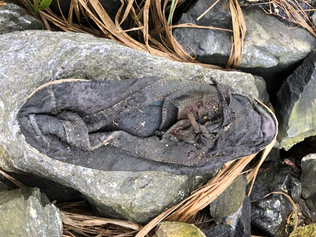
Rob texted a friend who had previously found a cache to see if we needed to be in the lower rocky area or all the way up the hill and another area. Since the coordinates were reported to be off by so much, we really had no idea where on the hillside we should search. He then moved to another area of rocks about 30 feet away. After I had hit every rock in two large areas, I started working my way back across them, picking up rocks to see if one was hollowed out. “I found a shoe!” I called out. “Is it the cache?” Rob asked. “Nope” And, I tossed it over my shoulder.
We continued searching for a little longer, and then both decided we had had enough. Our friend had not yet replied to the text, and neither of us wanted to continue to fruitlessly search through rocks when we didn’t even know if we were in the right spot. I said, “Let’s go hiking,” and Rob agreed.
We returned to the truck and headed toward the trail head. We had traveled about a mile when Rob’s phone chimed and he checked it. He said, “What kind of shoe did you find?” I said, “A black sneaker of some kind. Why? Was it in the shoe?” He said, “I think so.” The hint that our friend had given him sounded like that was it.
I turned the truck around and headed back. Rob asked if I remembered where I threw the shoe, and I told him I was pretty sure I could find it again.” When we arrived, I walked right up to the shoe, picked it up and poked at the toe. Sure enough. There was something inside. I reached in and pulled out a very muddy 35 mm film canister. While Rob was signing the log, I turned the shoe over and on the bottom, written with permanent marker it said…
I couldn’t believe I had been holding it and had tossed it away! Man did I feel dumb!
After we had replaced the cache, we climbed back in the truck and drove up to Sam’s Gap.
Now I’m just typing a bunch of nonsensical text to take up space and fill in the page a bit so that persons who are scrolling past this part of the story so as not to spoil their hunt for the cache I just told you about can get to the end of the spoiler story and start reading again without seeing what I wrote about that sneaky cache hide or see the photos that I posted of said cache and I realize fully and completely that this is a long, unnecessary run-on sentence full of many more words than are needed in fact one might call it superfluous which is just another word for wordy, synonyms for which include: surplus, redundant, unneeded, not required, excess, extra, spare, to spare, remaining, unused, left over; useless, unproductive, undue, in excess, surplus to requirements; expendable, disposable, dispensable, unwanted, waste. In other words, if you just read this whole paragraph, it was a major waste of your time!
Are you still with me? If so, after you see the next words in large font our story will continue.
Are you ready? Yeah. So am I.
OK, here goes…
END OF SPOILER!
For those of you who skipped ahead, welcome back. For those of you who took time to read the above paragraph in its entirety, I apologize.
When we parked at the Sam’s Gap parking lot, it was a few minutes before 11:00. There were several vehicles parked here. The Appalachian Trail crosses under I-26 at this point, and this is a popular starting point for many day hikers. It is also where some of our caching friends hold an annual Trail Magic event for thru-hikers. This is a fun event that they schedule in the spring to catch northbound thru-hikers who have timed their hike to arrive in Damascus, Virginia for Trail Days.
The organizers of the trail magic bring a grill and cook hamburgers and hotdogs, serving them along with all kinds of yummy side dishes and deserts. Other attendees bring food and drink for the hikers. I have only been able to attend this once due to scheduling conflicts, but I met a lot of very interesting folks that were hiking the trail.
As I mentioned earlier, our plan was to hike southbound on the AT to find three caches, a round trip of about four miles. However, within a few hundred feet of parking, along the northbound section of the trail, was the first stage of a multi-cache that we wanted to visit.
A multi-cache is just what it sounds like. Rather than finding one cache container in one location, there are two or more locations and possibly two or more containers. The multi-cache in this case has four stages with four containers and is called “States of 4.” That is because each of the four locations are in a different state. We decided that since the first stage was so close, that we would walk up and find it. We knew that inside it would be the coordinates for the second stage, and we wanted to learn what those were.
We decided to leave our backpacks in the truck and pick them up on our way back to hike in the opposite direction. We grabbed our hiking sticks, and started up the trail. The trail climbs gradually from the highway up into the forest. The first stage of the cache is hidden just past a gate in the fence that marks the highway right-of-way. I had found this first stage in May 2014 when I was here for one of the Trail Magic events, and had signed the log. However, I had not saved the coordinates that are written inside for stage two.
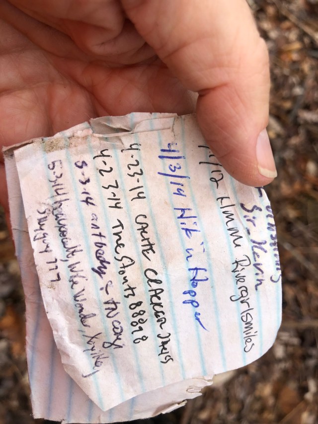
We signed the log, and got the coordinates for stage two. The note that provided the coords said that stage two was 1.09 miles away, northbound on the AT. We decided that since it was so close, we would just hike on and find it, stopping along the way for two other caches. In looking at the map, we had discovered that this would be a logical turn around point, and that on a future hike we could access the trail a short distance past that by traveling up a gravel road. This would allow us to do the next section of trail and log the caches along it, without having to hike all the way from Sam’s Gap. We briefly discussed going back to the truck for our packs, but decided that since it was just a mile and back, we wouldn’t need them.
I voiced the hope that it wouldn’t rain on us during our short walk, since our rain gear was in our packs. I was wearing a long sleeve shirt and hoodie, and Rob was in short sleeves. The temperature was 54° and the skies cloudy.
We headed in that direction, and soon stopped so that Rob could log a cache that I had found on the same day I had first visited the multi’s first stage. We found it quickly, but it took some time to retrieve it. The cache had been hidden high in the boughs of a large oak tree. Paracord is attached to the container, and hangs down from the tree so that you can used it to pull the cache down. However, the paracord was firmly wedged in the bark of the tree between two trunks and wouldn’t budge. After using his hiking stick to try to knock the container up and over, Rob was finally able to get it into a position where he could retrieve it.
As he was pulling it down, the container broke loose from the paracord. After he had signed the log, he began working to free the paracord from the tree’s death grip. Fortunately, Rob is a creative guy. He figured out that he could use the point on the end of my hiking stick to snag a loop in the cord, and push up to slide it loose. He had to periodically stop and tie a new loop in the cord until he had it completely freed, but finally got it loose. He then tied it back on the container and placed the cache back in the tree in a way that future hunters would not have the difficulty he had.
From this point we had a section of downhill hiking. I grumbled a bit about that, because it would mean hiking uphill on the way back out. Fortunately, it wasn’t very steep. Along the way we passed other hikers and their dogs. I wished that I had brought Andy with me. It had turned out to be a much nicer day than we expected.
After hiking about half a mile from the previous cache, we stopped to search for another one. Called “Looking Over Overlook” this cache is at a point along the trail where you can look down and see the overlook along the interstate where we stopped for our first cache of the day.

A whole gaggle of teenage girls passed by as we started our search, and I realized that a sound I had heard earlier and thought was a puppy barking was actually their chatter and laughter.
We spent thirty minutes here, searching for the geocache. It was another 35 mm film canister, originally hidden in a stump in 2005. In more recent logs we read that the stump no longer exists, so the tiny container is basically just on the ground, somewhere in the woods, under an eight to ten inch rock, near some stump remains.
We finally gave up the search, and continued on toward the second stage of the multi cache. With all of the off trail wandering we had done looking for caches, my tracker showed that we had already traveled 1.6 miles, and still hadn’t reached our turn around spot. We had been on the trail for an hour and 20 minutes, and had not brought along food or drink. It was about this point that we realized that when the cache owner had written in the note that the second stage was 1.09 miles away, he meant “as the crow flies” not trail miles.
A few minutes later we came to a blue blaze on a tree with a “Water” sign. Just off the trail was a spring coming out of the mountain. I briefly considered drinking from it, but wasn’t keen on the idea of gastrointestinal problems that might arise from drinking untreated water. I told Rob I had a LifeStraw filter, but of course it was in my backpack. In the truck.

From the spring, the trail began a steep climb, with steps in the steepest sections. We climbed 433 feet over the next half mile. Part way up the hill, I stopped to shed my hoodie as I was growing quite warm.

Eventually, we reached a point where our phones pointed off-trail toward the cache. We were making our way through the woods when Rob said, “I see something unnatural down there. Something blue.” We headed in that direction, and found the cache container lying on the ground next to its hiding place.
We collected the coordinates for the third stage, and signed the log. Rob plugged the coordinates for the next stage into his phone, and reported that it is near the state line of Virginia and Kentucky. Those are apparently the other two states in the “States of 4.” It appears a trip in that direction is in our future. Since we have found two of the stages of a four stage multi-cache, I have listed it in the stats above as half a find. Geocaching.com doesn’t count half finds, but I do!
We hid the container back where it should have been, and made our way back to the trail. Although we had climbed quite a bit to reach this point, we had not reached the top of this ridge. I was happy to head back to the truck, though. It was 12:45 and I was hungry!
The hike back down to where we had not been able to find the “Looking Over Overlook” cache went much more quickly than our trip up. I told Rob I wanted to give it one more quick search, and he grudgingly agreed. From looking at photos in previous finders’ logs, I am positive I found the spot where it was supposed to be. I even found an eight to ten inch rock, and debris from a rotted stump. But still no cache. We feel certain that it is missing, and would have replaced it with the 35 mm film canister I had in my backpack – if only my backpack had not been in the truck.
I did spot a cool looking shelf lichen during our hunt.

We gave up and hiked back to the truck. On the hike back, we noticed a few things that we hadn’t seen on the way in. One was a huge tree that had been split in half, probably by lightning.

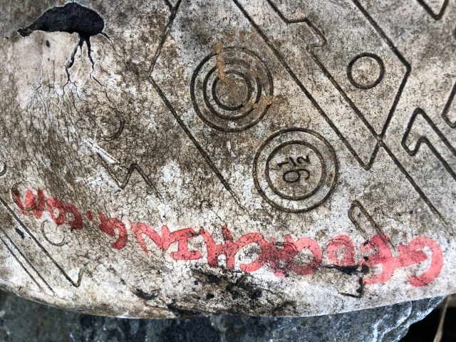
We also spotted the Appalachian Trail symbol carved in a log (see photo at top of post), and a pond far below the trail with a cistern next to it. We could see something red near the pond and floating in it that looked like gas cans. If that is what it was, how in the world did they get there?
We finally arrived back at the truck at about 2:00. We both grabbed our lunches from our packs before climbing back in the truck, and happily devoured them.
We had had enough hiking for the day, so headed toward home, planning to stop for a few caches along the way.
The first was a cache that I had looked for at a new park in downtown Johnson City called King Commons. For locals, this is one of the parks created during the flood abatement project for the downtown area. It is the site of the old U-Haul sign that has now become the Johnson City sign.
When we parked, we could see that two young men were sitting across the creek, facing in the direction that we needed to search. We decided to move on to another geocache, and come back later to find this one.
We drove to nearby Carver Park to find a BackWoodsAng cache called “Sketchy Bridge.” As we pulled up, there was a group of young men hanging around the area and we thought we would once again have to abandon our search. However, they soon walked across the bridge and out of sight, so we climbed out of the truck and began looking. This was a quick find, since we luckily chose the correct end of the bridge to look under first.
We then made our way to Founder’s Park to log a cache there. We parked across the street and casually walked toward the cache location. There were a lot of people here enjoying the mild weather, but I was able to grab the cache without being detected. I commented that the last time I visited this park, it was full of gay people. I had attended the first annual Tri-Cities Pride Parade here several months ago. I told Rob how much security was present that day, including police helicopters overhead, snipers on building roofs, and heavy police presence with their riot gear handy. Fortunately, all of that proved to be unnecessary. Despite there being protestors present, the day passed peacefully.
After logging the cache, we drove back to King Commons where we searched unsuccessfully for the cache I had not found before. I was hoping two sets of eyes would help, but no luck.
We made one more stop, visiting the location of a cache that Rob had not been able to find. Today it readily revealed itself, and he shook his head wondering how he could have missed it before.
It was getting late in the afternoon, so we called it a day and each went home to our sweethearts. I had time to relax a bit before taking a shower and going out to dinner with Deban and some friends.
Once again, the day had not gone as we had planned, but we had a great time anyway. It is good to make plans, but even better to be flexible when different opportunities present themselves.
