Bay’s Mountain Park
- 8.85 miles
- 5:50 duration
- 1104 feet elevation gain
- 2 geocaches found, several visited (previously found or to be logged in the future)
Lob the Huntsman (Ray) picked the day after Christmas as his day to log a very special cache in Bays Mountain park, and he sent out an invitation for others to join him. His goal was to hike to Adventure Awaits: Frequent Flyer Miles a challenge cache hidden by local geocaching legend DMflyer. In order to log this cache, one must have previously found at least 20 caches hidden by DMflyer with a terrain rating of four or higher.
All geocaches are rated on a scale of one to five for both difficulty and terrain. One is the easiest terrain and can be found by someone in a wheelchair. A five terrain cache typically requires a special tool such as a boat, climbing equipment, or flashlight. If a cache has a terrain rating of four or four and a half, it usually requires a substantial hike, or you have to navigate rugged terrain.
LakeBum (Rob), Cache Cracker Jacks (Tom and Dori), and I accepted Ray’s invitation to join him on this quest. Tom and Dori had already qualified for and logged the cache in April 2015. LakeBum (Rob) and I have hiked to many of DMflyer’s high terrain caches together, and I was qualified with 24 finds, but Rob only had 15 so I decided to wait to log the cache when I can do it with him. But, we rarely turn down a chance to hike at Bay’s Mountain so decided to go along for the ride…I mean hike.
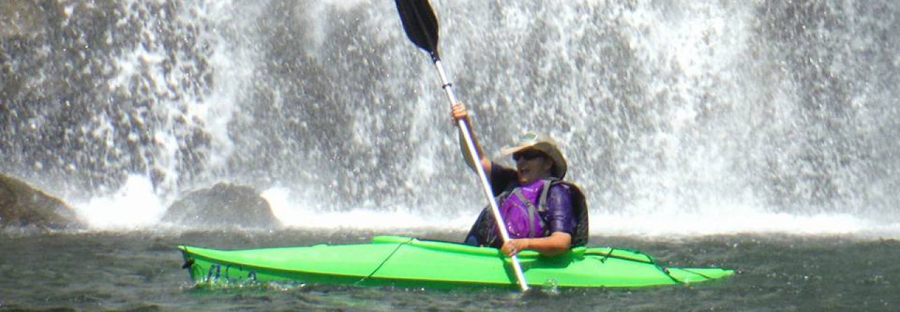
It was a cold day, so I came prepared wearing several layers of clothing. I was just happy that the wind was not blowing like it had on Christmas Day. While waiting for Rob and I to arrive, Ray, Tom and Dori went down to see the waterfall in Dolan Gap and reported that it was flowing well and icy. I’m sorry I missed seeing it since there was very little flow when Rob and I hiked past it earlier in the month.
Since this was Ray’s day, we gave him the job of planning our route. He led us around the lake on Lake Road, following it up to Feagins Gap. We then took River Mountain Road up toward the top of Bay’s Mountain. Along this steep climb, we were happy to stop so that Ray could log a geocache hidden by BackWoodsAng that the rest of us had already found. This gave us time to regain our breath before continuing the climb.
At this spot we also saw the craziest icicle. It pointed out from the rock wall at about a 75 degree angle rather than straight down. I can only surmise that the wind caused the water to resist the pull of gravity as it froze. Either that, or it had taken Viagra.
A little further up River Mountain Road was a fairly new cache hidden by Cache Cracker Jacks. This was one that Ray, Rob and I had not yet found, so we were happy to sign the log sheet under biblemanrick’s name. He was the first to find (FTF) on December 4.
We continued on up River Mountain Road to the top of the mountain, and turned left. This was new territory for me. The trail follows a tall chain link fence along the ridge line. Below us to the north we could see the river and Holston Army Ammunition Plant. Built during World War II, this facility (then known as Holston Ordnance Works) produced explosives for the army.
When we reached a gate in the tall fence marked Gate 10, we stopped so that Ray could log the Adventure Awaits cache he was seeking. After Ray located the cache we checked out its contents. He had been asked by biblemanrick to grab a travel bug he had left there in 2013 so that it could continue on its journey. There was also a rare green jeep travel bug in the cache that I traded for since it had been sitting there for more than two years. Ray then mugged for the camera, and celebrated his find.
In addition to the thrill of logging this challenge cache, and remembering the 20 DMflyer high terrain caches that brought him there, Ray was marking the two year anniversary of finding his first geocache – another DMflyer hide. Even more remarkable is the fact that Ray has not missed a single day caching since he found that first cache, so this was his 731st consecutive day of finding a geocache. This is the 6th longest streak of cachers in the state of Tennessee, and the longest active streak so if he keeps it up, he might just surpass all the rest.
The cache was hidden under a large downed tree that made a great place for us to sit and eat our lunch. By this time we were 3.5 miles and a little over two hours into our hike. While we ate, we discussed where we would go from there. We could simply head back down the way we had come. We could follow River Mountain Road over to the fire tower and come down Fire Tower Trail or even follow the ridge to the antennas and come down Big Oak Trail. Or, we could take the Indian Pipes Trail down to Pretty Ridge Trail, and follow that on down into Back Hollow.
When Dori heard the words, “Back Hollow” she perked up and said, “Ooooo! The homesteads!” That decided it. As we packed up and headed in that direction, I suddenly realized; if we went DOWN into Back Hollow, we would then have to go UP Back Hollow to reach Feagins Gap. Oh well, it would be worth it to see some of the old structures again, plus I looked forward to experiencing the Indian Pipes Trail for the first time.
We made a quick journey down this beautiful trail to its intersection with Pretty Ridge Trail, and then followed Pretty Ridge down to the Bill Simpson homestead. As the old barn came into view, both Dori and Rob told the rest of us that this was their favorite spot in the whole park. It is definitely a beautiful area and very peaceful. A small stream flows past the barn. A little further up the trail is the cabin. Both structures are slowly collapsing and being reclaimed by the forest, but it is nice to imagine what life must have been like in this idyllic setting.
Ray logged the very clever geocache hidden at the cabin (a LakeBum hide), and then we began the hike up Back Hollow. Our next stop was at the Primitive Cabin where a BackWoodsAng cache is hidden. Further up the trail Ray, Rob and Dori detoured along a lower trail toward the smoke house so that Ray could find another cache hidden by G.I. *Geo. Tom and I stayed on the main trail and watched their progress from above.
Once we arrived back at Feagins Gap, we had yet another decision to make. Rob asked Tom what he thought was the best route back. Tom asked, “The shortest, the easiest, or the most direct?” He suggested that we take the most direct route – Lake Road up to Cherry Knobs Trail, and down Cherry Knobs to Lake Side Trail I was happy to hear the words “Cherry Knobs” because there was a cache along that route that I needed to log. Rob and I had hiked it last winter, but at the time this particular cache was missing. It had since been replaced and I was eager to get that lone green icon off my map.
The climb up Lake Road to Cherry Knobs was brutal after all of the hiking we had already done. After all, we had already hiked seven miles by this time. There was a lot of groaning and complaining as we dragged ourselves up this quarter mile stretch. We finally made it and started down Cherry Knobs Trail. This is a very steep descent in places, made more treacherous by wet leaves, but thankfully we all made it safely. We stopped along the way for Lob to log yet another cache, and then for both of us to log the cache I was lacking.
We continued down Cherry Knobs Trail to Lake Side Trail, and crossed the floating bridge. Ray and I were lagging behind as the others started across the bridge, and suddenly I heard the most beautiful, haunting sound. It sounded like glass wind chimes. As we walked onto the bridge, I realized that it was the sound of the ice on the water. Tom, Dori and Rob were rocking the bridge, causing it to move against the ice. As each section of ice moved against the next, rippling across the pond, it created a magical melody. I encouraged them to do it once more so that I could record video in an attempt to capture the sound.
From here it was a short walk to the dam, and then we had one more hill to climb to reach our vehicles. As tired as we were, Rob and I discussed our next excursion on the drive home. We decided we wouldn’t be up for another long hike the next day, but hoped to be able to tackle Temple Hill later in the week. Stay tuned to learn if we made that trek or not…


Another good read, thank you. Loved the photo of the excited icicle. The abandoned barns and homesteads looked interesting, another world from where I am. Glad you had a good hike and managed to get a couple of geocaches. Hope you get the two new souvenirs.
I have earned my last day souvenir while visiting family in a town near where I grew up. I am now on my way home, and tomorrow plan to hike for some more caches and to earn my first day souvenir. Happy New Year!