
Appalachian Trail ~ Iron Mountain
- .5 mile/7.51 miles
- :25 duration/5:10 duration
- 140 foot elevation gain/2,003 foot elevation gain
- 59° F High/44° F low
- 15-30 mph winds
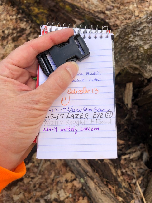
- 7 geocaches found (1 before hikes/6 during hikes)
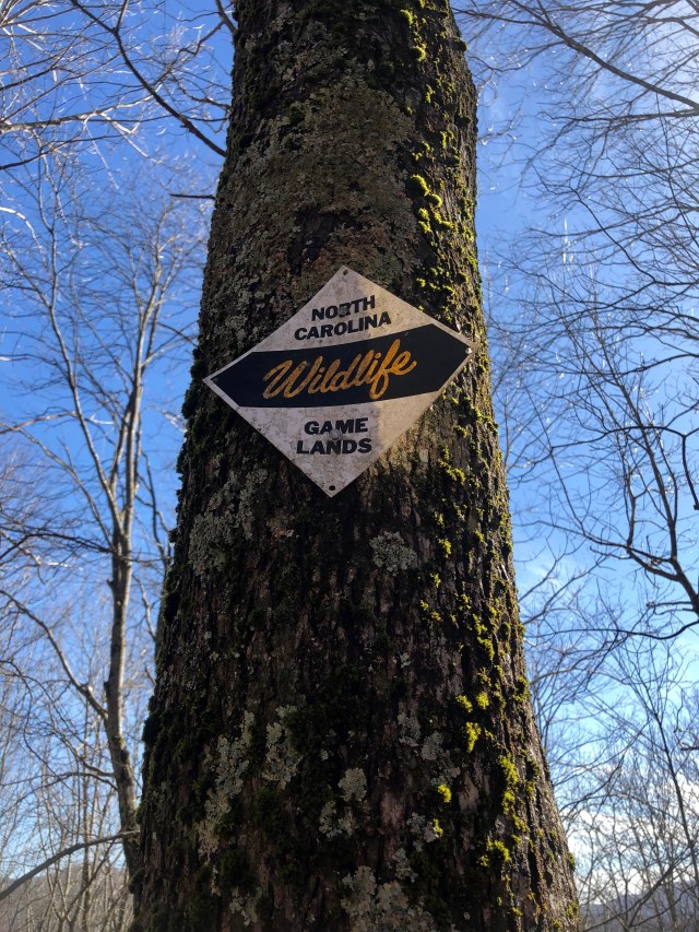
After a great hike last week on the Appalachian Trail, LakeBum (Rob) did some research and identified another section of the trail that offered more geocaches. It was again along the Tennessee/North Carolina border. As we checked the weekend weather, it appeared Sunday would be more conducive to hiking.
In fact, we have had a very wet February with over 10 inches of rainfall. The ground was saturated, and several areas around us were experiencing flooding. Saturday was no different with rain all day long equaling a record 1.83 inches for this date. There were times during the day that I wondered if the forecast for Sunday could possibly be correct.
Sunday dawned with mostly sunny skies and mild temperatures, just as the meteorologists had promised. As they had also promised, it was quite windy as well. I had a fleeting moment of concern about the wisdom of hiking in a forest in high winds after so much rain had softened the ground. But, I was eager to get out and play on such a beautiful day.
Rob and I headed out toward Unicoi County, marveling at the beautiful weather. At one point in the journey, I suddenly realized that I had been busy talking and had driven past the exit for the Town of Unicoi. I took the next exit, and Rob reminded me that the final location for a puzzle cache I had recently solved was at this exit, so I stopped to find it. This was a fun puzzle created by Reis’s Pieces (Scott) which involved identifying interstate numbers based on descriptive paragraphs in order to obtain the coordinates for the cache. It was a puzzle I had started working on a few years ago, but had given up on because I hit a roadblock (pun intended). When I tried it again recently, I was once again confused on part of it, but after a nudge from Rob realized I had not been reading the descriptions closely enough. I was glad to finally solve this puzzle and log the cache.
Rob then navigated for me as I drove back roads until we reached Highway 107. We followed it to Iron Mountain Gap where we would begin our hike. Like last week’s hike, there was one cache on one side of the gap, and five more on the other side of the gap. We had once again decided to look for the single cache first, and then hike to the others.
As I started to park, Rob mentioned that there were two parking areas listed for that first cache. The first was next to the highway, and the second was along a dirt road that would get us about .4 mile closer to the cache. I decided to investigate the road and see if it was passable. It was a bit muddy and rutted, but with four-wheel drive and my high-clearance truck I was able to drive up it to the closer parking area.
We took our hiking poles with us for the short trip, but left our backpacks behind. I did not track this hike, but have posted above the stats as noted on the cache description. The Appalachian Trail runs parallel to the road at the point we parked, so we accessed it and hiked south along mostly level ground. We soon came to a spur trail, and followed it up the hillside toward the cache. The hint said to “Leave trail near a large tree with an unusual base.” At the top of the hill we spotted such a tree, and turned to walk toward the cache.

We were still quite some distance away when Rob said he saw it. I looked in the direction he was pointing, and could see something reflecting sunlight. When we arrived, we could see that it was a metal ammo can in very good condition. Rob enjoyed playing with some of the swag while I signed our names to the log.

Once we had finished, we covered the cache better than we had found it, and headed back to the truck. As we descended the hillside, we noticed another interesting tree that was pointing at the trail we had just come from. Perhaps a “trail tree“?
As we neared the truck, we met the only other humans we would see on this day, a couple that was hiking the trail near where we had parked. We greeted them and shared our enthusiasm about the beautiful weather. I am surprised we didn’t see more people out hiking today, but perhaps others were smart enough to stay out of the woods on such a windy day.
I drove back to the parking area along the highway, and we headed out to hike north-bound on the AT.

We steadily climbed about 300 feet in elevation for the first .58 mile. I had not slept well the night before, and was already feeling fatigued. I munched on a Quest protein bar as we hiked because I felt as if my blood sugar might be dipping. That helped somewhat, but I was felt a bit sluggish.
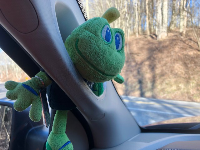
We had not gone far when I realized I had left Signal the Frog in the truck! I tried to talk Rob into going back to get him, but he said he would just wait while I did. I wasn’t about to have to backtrack, so resigned myself to hiking without him on this trip.
At the .58 mile point, we went off-trail down a steep slope in search of the next geocache. Our phones’ GPS signals were very shaky here. We spent about 20 minutes searching a radius of about 50 feet without success. Finally, Rob looked again in a spot that he had looked earlier, and found the cache hidden inside a hollow log. What a relief to have located it! My Garmin watch recorded an extra .20 miles walked during this search. I’m not sure if that was accurate, or if it was also having difficulty maintaining a good lock on the satellites.
We then climbed back up the to the trail, and continued our hike. Over the next .50 mile we gained another 170 feet in altitude. As we neared the next cache, our phones were pointing straight ahead, and the trail curved downward to the right. We did not want a repeat performance of last week’s ordeal when we decided to follow the trail hoping to get closer to the cache. That error meant we had to climb a hill we had just descended in order to battle through blueberries to reach the cache.
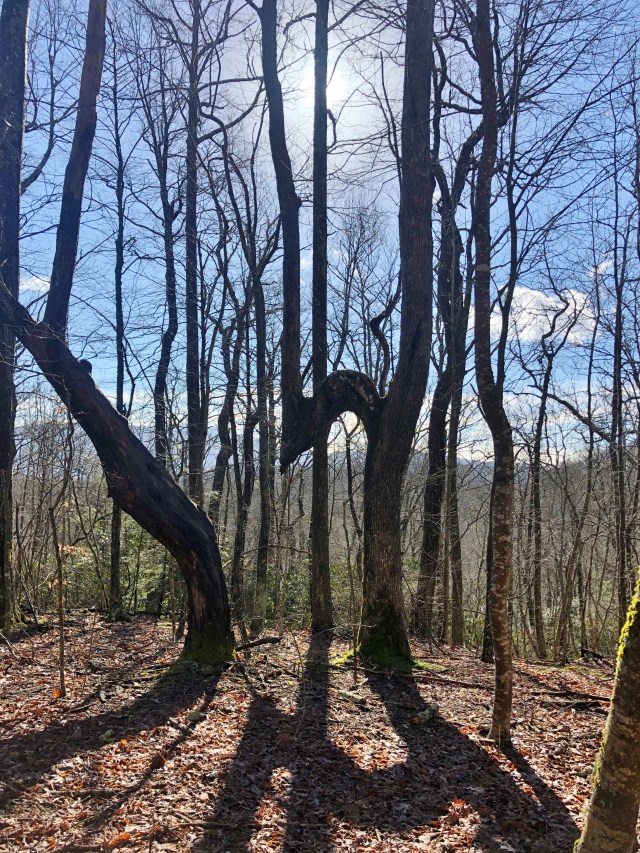
We had noticed that although we were not very far from the section of trail we had hiked last week, that the forest was very different here. Rather than the thick undergrowth on the forest floor, this had very little growth between and under the trees. This made journeying off trail much easier. We continued along a ridge line for several hundred feet. The wind was blowing very hard here. I had taken off my hooded sweatshirt earlier because I was growing warm on the climb up the trail. The cool wind made my ears ache but I didn’t want to stop and put it back on. Along the way I spotted a sign indicating we were along the state line. In fact we would cross the state line several times during this day’s hike.
Eventually, our phones pointed us back down toward the trail. When we were just feet from the trail, Rob found the cache. It was then that I read the cache page and saw that it described the cache as being just 20-25 feet from the trail. Had we stayed on the trail, it would have been much easier to reach. We never seem to take the easiest route!
From here, the trail continued downward. Thankfully, the mountain blocked some of the wind, making it a more pleasant temperature. Soon, we arrived at a meadow, a surprising sight near the mountain tops. I later learned that this was once the site of an apple orchard.
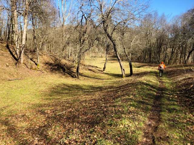
Halfway across the meadow was another unexpected site. Next to a sign pointing toward a spring where hikers can find fresh water, was an old metal stool. We wondered how it had come to be there, but since this used to be an orchard, it must be a remnant from those days.

From the meadow/apple orchard, the trail continued to descend until we were at 3,871 feet – exactly 200 feet higher than we had been when we started. Then, we began to climb again. Up, up and up.
Around the two mile mark of our hike, we neared the next geocache. This one was called “At a Crawl’s Pace” and that is about how fast I was hiking. On most hikes, Rob and I tend to hike at the same pace, with him leading part of the time and me leading part of the time. He had been ahead of me all day, and there were times that I was struggling to match his pace.
We arrived at the spot where we would go off trail to find the cache, and found that it was 175 feet up a steep hill. Ugh! We began making our way up the hill, and then began searching in places that matched the hint: Base of log lying uphill. If you have ever hiked in the forest, you may have noticed that there are a LOT of logs lying about.
We were probably 50 or so feet apart when Rob shouted, “I see it!” I looked up the hill and shouted back, “So do I!” We converged on the spot and found a very sad container lying in the open. It was once a one gallon plastic jar, but has been chewed on by animals. The lid was about 10 feet away. There was not a log sheet in it, only a plastic bag with a few pieces of swag.
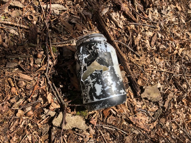
In reading back through past logs, I have learned that cachers who found it as far back as 2011 reported teeth marks in it. Each finder has replaced it, only to have animals drag it out again. I wish I had read these logs before our trip so that I would have come prepared to replace it.
Rob did have an Altoids tin in his pack that had a log sheet in it. He placed that inside the container, and we nestled it in a spot next to where we found it. I scoured the hillside for rocks, finding only one. We used it and several sticks to further hide and protect the cache, hoping that the animals will leave it alone. I have my doubts.
It was a ten minutes before noon at this time, and we would normally stop and eat. However, we decided that we would press on to the next cache. I had eaten the protein bar earlier, and Rob had a Kind bar now to tide him over.
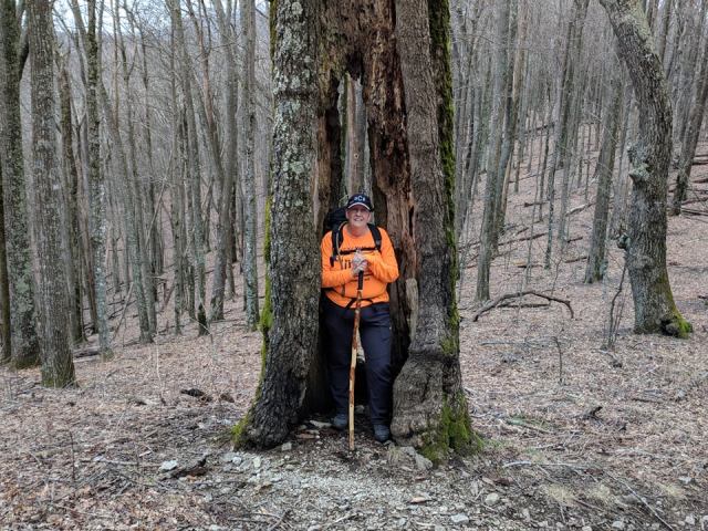
We went back down to the trail and resumed our hike. I found a cool tree along the way, and stepped inside it. Rob said, “I guess you want me to take your picture.” Of course I did!
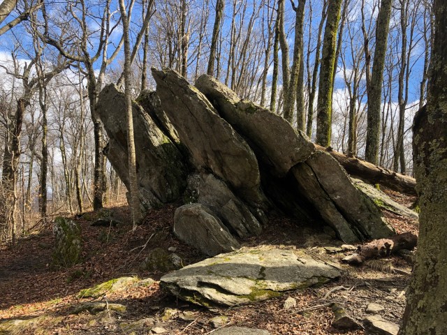
The trail continued to climb up, up, up. Two hours into our hike we reached the highest point of the day at 4,380 feet. There was an interesting rock formation here that begged for a geocache. Sadly, there was not one here, so we continued on.
The trail went down some, and then back up. We had been on the trail two hours and 15 minutes when we arrived at the next cache. It was a very well-stocked ammo can and Rob once again made the find.

After replacing the cache in its hiding spot, we agreed to have lunch. Rob sat on the rock that the cache was hidden under, and I claimed a spot on a nearby fallen tree. The wind was still blowing very hard, and I was thankful I had my sweatshirt with me. I put it on and pulled up the hood to cover my cold ears. I was quite hungry by this time, and my peanut butter and jelly sandwich tasted heavenly. Since it was cold, we did not linger very long. We still had one more cache to find, and a long hike back to the truck.
That last cache was at the four mile mark of our hike. This was a little further than the distance described in the cache page, but included the off-trail walking we had done while searching for caches.
Rob was again the first one to spot the cache, making him six for six this day. Basically, my only contribution to this day’s geocaching was driving the truck and keeping him company.
This was a cache resurrection for us. The cache had last been found in July 2017. Once we had logged it, we began the long hike back to the truck.
The return hike was uneventful. We did stop at one point to do some trail maintenance. On the way in, we had passed a section of tree that had fallen and covered the trail. Rob pulled the new hand pruners out of his pack that his mother gave him for Christmas and began snipping off branches that blocked the path.

I leaned against my hiking stick and watched, but then Rob mentioned that some of the branches looked too thick for him to cut with his pruners. I grabbed one of them, stepped on it, and pulled up in an effort to break it. When it gave way, I lost my balance and flailed about for a bit before landing on my butt. Nothing was hurt but my pride.
I had stepped out of the way and let Rob continue his work when I noticed that my efforts had left a dangerous-looking broken end projecting into the pathway. I suggested that we see if we could drag the whole limb and its branches out of the trail rather than leave that exposed sharp end sticking out. Before I could get to it, Rob had grabbed hold and dragged the whole thing far enough off the trail to completely clear the route. He commented that we should have tried that to begin with and saved him a lot of pruning.
We congratulated ourselves on doing our good deed for the day, and continued with our hike. The wind was still blowing very hard. Over the roar of the wind, I could hear trees “screaming” as they rubbed together and other trees “chattering” like squirrels. Many times throughout the day I saw or heard pieces of trees falling near us, but fortunately we were never hit.
I had restarted my Garmin watch before we left the last cache to see what the difference in distance was between the hike in and the hike out. Rob also logged the return on his phone using the Runkeeper app. When we had arrived back at the truck, both devices had logged 3.51 miles. It had taken us three hours and 13 minutes to hike to the farthest cache, but only 1:56 to return. We were thankful that much of the return trip was down hill with only a 646 foot elevation gain and a 1,192 elevation loss.
When we got back to the truck, I found that Signal was still smiling from his perch near the windshield. I guess he didn’t hold my forgetfulness against me after all.

Sounds like quite the adventure