Trail Mix Year 7 – Laurel Run Park
- 6.14 miles
- 5:24 duration
- 1,129 elevation gain
- 3 geocaches found
- 1 geocache replaced
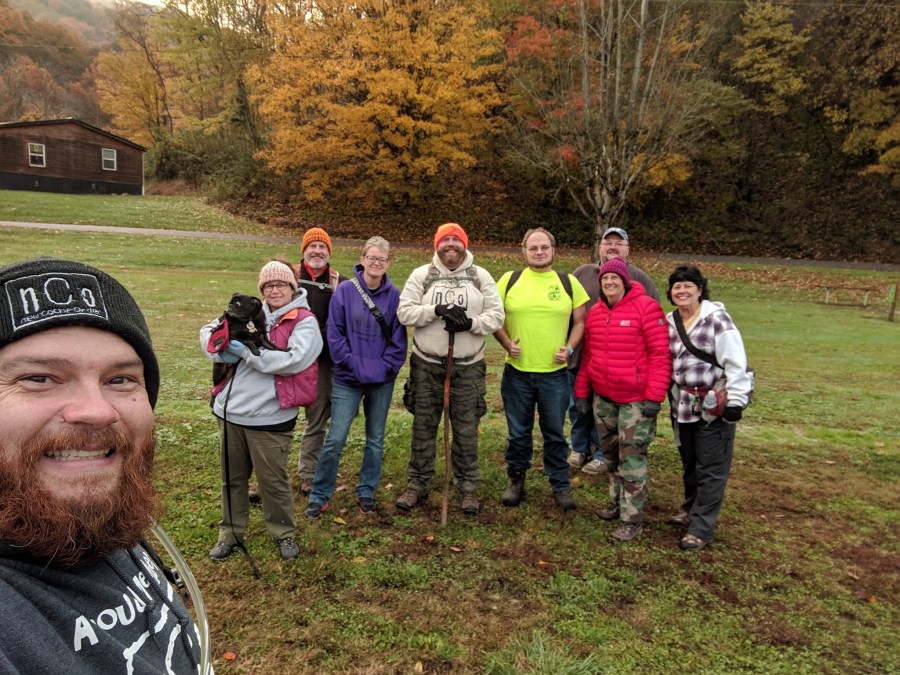
Each year I anticipate the Trail Mix event held by my friends Cache Cracker Jacks (Tom and Dori). This event is typically held at Bays Mountain Park, and I have attended six of the seven years, only because I didn’t know about it the first year. Each event starts with a meet and greet, followed by hiking and geocaching, weather permitting. There have been a few years that we have had to forego the hiking portion, as well as a couple of years that we hiked in the pouring rain.
This year, however, dawned cold but clear in the high 30s. I picked LakeBum (Rob) up at 7:20 am and we both did a fair amount of complaining about the early hour on the way to Church Hill. We spent some time in the parking area chatting and waiting on everyone to arrive. I was wearing a long-sleeve t-shirt and my down jacket, but was getting cold just standing around. I pulled out my hooded sweatshirt and put it on beneath my down jacket. This felt much better.
After taking a group photo we began the hike at 8:50. Nine of the ten humans who had attended the meet and greet headed out for the hike along with two canines.
The first stop was at the park office so that those who had not previously logged the cache there could experience it. It is a fun field puzzle – something you have to solve in order to open the cache container. We then started up Laurel Run Trail, making another stop at the log buildings for those who have not visited this park to log a cache hidden there.
A little further up the trail we all had the opportunity to log a brand new geocache, hidden by BackWoodsAng earlier in the week. It is named Natural Bridge because to reach it you must cross the creek. You can do this on the “natural bridge” (a fallen tree) or by rock hopping. Tom immediately jumped on the tree and walked across, making the journey look easy. I followed him a little more slowly, with SpongeBob Cachepants (Kelly) and Masked Llama (Tony) following me. Rob and Coolhipwithit chose to rock hop.
By the time the rest of us had made it across, Tom had found the cache. After we had logged our find everyone began making their way back across the creek. I got halfway across the log before my brain kicked in making me doubt my balance and my knees started shaking. I stepped off to let Tom pass me, and then I rock hopped the rest of the way across the stream. I guess the excitement of finding a new cache had gotten me across the first time, but without that adrenaline I was too unsure of myself to cross the natural bridge a second time.
Back on the trail, we started the climb up the first significant hill. The fairer 1/3 of team Mandalorian Steelers (Melissa) and I stopped many times along the way to photograph the many fungi she spotted. She is not as involved in geocaching as her husband and son, but enjoys hiking with us even when they cannot.
We stopped at the top of the hill so that folks could search for and log the cache I had hidden two weeks ago. I heard a few grumblings about the hint I provided: “Hidden beneath the roots of a fallen tree that ends next to a moss-covered rock.” There are many fallen trees and moss-covered rocks in the forest! But, Kelly found the cache fairly quickly and we continued our journey.
When we reached the creek crossing tncorgi (Mary) and her dog Bane turned back as they had other places to be that day. All of the remaining humans crossed the creek on the strategically placed rocks, but Kudzu (Tom and Dori’s geopug) was still on the other side. He seemed nervous about rock hopping with his short little legs. Tom went back and carried him across. Such a good dad!
Rob and I then paused, letting everyone know there was another new cache nearby. Some of the group began looking, while others tried to pull it up on their phones. One person found it by looking up the name (Laurel Run Park – Rock Hop) but said it was .5 mile away according to his phone. I pulled it up, and indeed the map showed it being .5 miles away. Apparently, there was a glitch when Rob submitted it, and the coords were entered wrong.
We gave them guidance, reading the hint aloud, so that they could search for it. Even with several people searching in the right spot, it took them several minutes to find this well-hidden cache. Eventually, it was found and the log sheet signed.
The wild phlox that I had spotted on our previous hike were still blooming, and I found several more of them nearby along with a type of goldenrod that is more common this time of year.
We then made our way on up the trail toward Laurel Run Falls, pausing again so that those new to this park could cross the creek and find a cache Rob had hidden in 2017. Tony crossed the creek on another fallen log and then climbed across the end of the one next to it. I heard someone remark, “Who knew that Llamas can climb trees?” Kelly chose to rock hop this time. They found the cache and signed it for everyone who had not yet logged it.
Once we reached Laurel Run Falls, we all took time to take photos. Although I have taken countless photos of these falls, I decided to cross the creek as Rob had two weeks before and take some from that side. It is amazing how different the falls look from a different vantage point. On the way back across the creek, I found the perfect spot to hold my phone perfectly still so that I could take some long exposure shots of the falls. I was actually pleased with the results: not the quality of photo I can get with my DSLR camera, but pretty nice for a cell phone pic.
We stopped near upper Laurel Run Falls (one of the smaller five-foot drops in the park) so that some in the group could log the cache near them. I once again busied myself with taking photos, enjoying the color of the fallen leaves surrounding the water.
We then continued up the trail past the switch backs near the confluence of Kiner Creek and Laurel Run. This is different from the route Rob and I had taken on our previous hike, but there was another new geocache up this way to be found. This part of the trail and those it connects to lead all the way to Bays Mountain Park. I have hiked to the park boundaries from both directions, but someday would like to do a through-hike beginning in Bays Mountain and ending in Laurel Run.
The fall colors in this area of the park were glorious. The sun had begun to peek through the clouds and the day was warming up enough that I could shed one of my three layers.
We stopped at the first of several historic home sites along this trail, the Morrison family cabin. There is a cache hidden there that some in the group needed to log. Despite the fact that several of us had already found it in the past, it took quite some time to uncover it from its hiding spot in the remains of the chimney. It had not been found since Rob and I logged it along with some other friends in December 2016. During the last two years it had become covered with debris and was buried deep beneath the stones of the chimney.
Another .2 mile up the trail we arrived at the farthermost point in our hike, Asa Simpson cabin. It was here that Ang had hidden another new cache this week. It was a doozy: a very large ammo can filled with swag and trackables. He must have been exhausted after carrying such a heavy load this far. He had also included first-to-find prizes for all of us: custom made, unactivated trackables with the nCo logo on them. What a treat!
We then turned and retraced our steps back to the confluence of Kiner Creek and Laurel Run. We stopped there to eat lunch. Most of us found rocks to sit on or stood to eat, but Tom followed his Trail Mix tradition of stringing up his hammock. When we had finished, Kelly and Melissa both took their leave of the group.
The rest of us crossed Kiner Creek and followed it up to Kiner Falls. Two of those who were still with us had not been here before and were in for a treat. This is such a beautiful waterfall well worth the effort it takes to reach it. Several of us had tried again to find DMflyer’s cache that was hidden here in 2004 but still could not locate it. I had a small plastic container in my pack that I used to replace it so that those who had not yet found it could log it. Someone in our group will come back out soon to swap out that container for one more appropriate to this unique spot.
Before we left, I asked Dori if she wanted to “take a shower” under the falls. She first said no, but I could tell that once I put the idea in her head she was tempted. In unison, we both started shedding our top layer of clothing. We then stepped beneath the waterfall whooping and hollering. The water was pretty chilly, but invigorating. Afterward, I removed my wet t-shirt and spent the rest of the day in my hoodie.
We hiked back to the main trail, and then followed it to the junction with the CMOR Loop Trail. We gave the two hikers who have not been here before the choice of returning to parking or taking the loop so they could log the two caches along it. They chose the loop, so we began the long, steady climb. We stopped so they could log Rob’s cache, and then continued to the overlook. There we took in the views, and then bushwhacked up to the first stage of Tom and Dori’s muli-cache.
Finally, we began the steep descent back toward parking, stopping off so folks could log the final of the multi-cache. When we arrived back at the vehicles, we had logged a little over six miles in five hours twenty four minutes.
After saying our goodbyes, Rob and I decided to take an alternate route home. I had asked him if it was possible to approach one of his caches hidden in Bays Mountain from the back side of the park. Called “Way Out Back Hollow” it would be a very lengthy hike from the front of the park. We have hiked in that direction a few times in recent years, but have never continued on to that cache. We decided to scout it out to see if this would be possible.
We knew that there is access to the park from the lower end near where Back Hollow Trail and Front Hollow trail meet. A few years ago I joined a group that hiked all the way to the end of Front Hollow collecting trash and posting signs for the park. They had been having difficulty with folks riding ATVs in this area of the park and tearing up the trails.
Rob used a map on his phone to guide me as I drove. We wound around on back country roads that got narrower and rougher the further we went. When we passed a dead end sign and continued on a road that looked more like a driveway. I remarked that I hoped we wouldn’t get shot out here. We finally reached the end of the paved road and parked next to an abandoned saw mill.
Past it was a dirt road leading past one of those signs we had posted a few years ago. About a tenth of the mile down the road, we stopped to look at the map and see if we could figure out where the two trails meet.
A man working in a field nearby called out to ask if we were lost. Nervously, I responded that we were looking for Back Hollow Road. He told us that it was just to our left through the barbed wire gate. He then came down to talk to us.
He was very friendly and welcoming. He told us more about the trails, and pointed out the park boundaries. He also told us we could park by the saw mill or next to his house any time we wanted to hike here.
We went through the gate he had indicated, and followed Back Hollow a little way. It looks like it will be a nice hike of about a mile to reach the cache. We may even come prepared with some new caches to hide.
We returned to the car, and headed for home, thankful for another great day with friends, enjoying God’s beautiful nature.


