South Holston River
- 14.75 miles
- 4:24 duration
- 3 geocaches found
It had been seven weeks since I last paddled Huck. Far too long! I had talked with Porknbeans (Jane) earlier in the week about rectifying that this weekend. Then, LakeBum (Rob) also asked if I wanted to paddle the Watauga River with him, Richard and Berta. I told him we were thinking about the South Holston, a river I haven’t had the chance to paddle in a couple of years. He said that was also a good choice, as long as TVA cooperated by providing enough flow through the South Holston Dam.
On Friday, Rob checked the TVA website and learned that while they would not be running generators on Saturday, they were planning to sluice: release water from a gate near the base of the dam. This should provide enough flow for us to paddle this river. When TVA is not generating or sluicing, the water level is too low in some places.
We agreed to meet at the boat ramp in Bluff City at 10:00 am. There, we would check the water level, and decide whether to paddle 14 miles from South Holston Dam to Bluff City, or to end our trip after 6.5 miles at the Big Springs Road takeout.
Rob picked me up, and we drove to Bluff City. When we arrived, the water appeared to be moving very quickly so we decided we would do the longer trip. While we were waiting for Richard to arrive, I walked across the street to log a cache hidden at a caboose. It was an easy grab.
Berta had decided not to join us on this trip, so it would just be four of us. Once Richard arrived, his canoe was loaded into the back of Rob’s truck, and then we made our way toward the South Holston Dam to meet Jane.
There were a lot of drift boats on the river at the point where we launched. There was also a weir dam here, but we carried our boats down the shore so that we could launch below it. Even here, the current was very swift, so we knew that as soon as we launched we would need to start paddling immediately.
Three of us were sporting new equipment on this trip. Rob and Jane both had new helmets. I had a new NRS life jacket. We all looked pretty spiffy in my opinion.
The day started out a little on the cool side, but by the time we hit the river, it had warmed up to a comfortable temperature. We had blue skies with a few clouds. There was a little bit of fog just above the water in some places.
With the higher water levels, there were no technical rapids to deal with. We did encounter many wavy areas that were fun to splash through. We were moving quickly for much of the trip, even if we didn’t paddle. According to the app I used to track our trip, we averaged 4.9 miles an hour throughout the duration of the trip, with a maximum speed of 9.1 mph.
The speed of the river made it a little challenging when we wanted to pull over to shore for a stop or even pause to take a photo. I first experienced this when I spotted a large metal sculpture of a trout along the shore, and paddled over to take a photo of it.
Not long after this, we pulled over so that Jane and I could log a cache Rob had hidden a couple of years ago. I was somewhat lazy and didn’t get out of my boat. Jane found the cache container lying in a puddle of water. It had come loose from its tether. While she was signing the log, Rob found the cord still attached to the tree, and he re-tied it on the lid of the container. It is amazing that the container had not washed downstream.
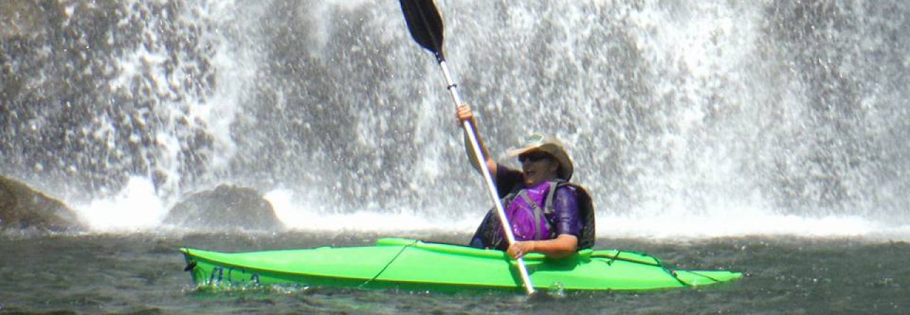
We continued downriver, passing under a beautiful, old, abandoned bridge. About 15 minutes later, we stopped once again to see a waterfall that is on private property. It is about 15 to 20 feet high, flowing over a ridge and into a stream leading into the river. Rob and I paddled up the stream to get a closer view of the waterfall. We had seen it on previous trips, but not with as much water flowing as today.
Just across the river from the waterfall was an interesting little cabin perched on a hillside. It does not look as if it is currently inhabited. It is rustic, but something about the tin roof and clapboard siding gives it a certain charm.
About 15 minutes later, we came upon a park-like area that looked like a nice place to stop for lunch. There were some picnic tables as well as a very interesting tree house. We sat at one of the picnic tables to enjoy our meal. We were entertained by a granddaddy long-legs that had picked up a bit of tuna from Richard’s sandwich and was feasting on it. While the amount seemed minuscule to us, it was actually larger than the body of the insect.
Sitting in the shade, and feeling the breeze, I was actually a little chilly because my sleeves were damp from being splashed by the waves. It felt good to get back out into the sun and on the water.
Once back on the river, we soon passed the take out point at Big Springs Road. It didn’t seem like we had been on the river nearly long enough so I was happy we had decided to paddle on to Bluff City.
Soon, we saw the most interesting sight of the day: an old Ford truck perched in a tree. It begs the question. How does a truck end up in a tree?
Just a short distance further was a very nice home alongside the river. While we agreed that it was too close to the river for comfort if there should be a flood, it was still very appealing. Half of it (apparently the original home) had a river rock exterior. The other half of the two story structure had a very large screened room on top of an equally large room with large windows overlooking the river.
The home had very nice landscaping, including a beautiful footbridge across a stream flowing into the river. I paddled up the stream as far as a culvert running under the nearby road and it seemed magical with skittering water bugs and beautiful dragonflies flitting about.
About 30 minutes further downstream, I spotted another unusual sight. A few weeks ago we had traveled to Norton, VA in search of the Woodbooger: a Sasquatch type figure believed to inhabit the forests there. Little did we know, he lives right there alongside the South Holston River! Really! I saw him! What? You don’t believe in the Woodbooger? Well, that’s okay. He doesn’t believe in you either. But, if you scroll down you will see photo evidence of this sighting.
In researching this stretch of river, I had noticed a geocache hidden on an island in 2007. The last people to have logged online that they had found it, posted that log in July 2014. Rob and I decided we needed to stop and search for it. Jane had found it back in 2008.
When we arrived at the island it was on, we found a spot that we could get out of the swift current and exit our boats. Richard waited patiently for us as we made our way into the woods in search of the cache. Rob spotted it quickly – a large ammo can nestled next to a fallen tree. Once we opened it, we found a great selection of swag, and a bone-dry logbook. The cache was in excellent shape to have been hidden here for 11 years.
When we opened the logbook, we discovered that the last logs in the book were dated October 21, 2012! Research after I returned home makes me believe that the log posted in 2014 was in error, so it had actually been nearly six years since this cache was last found. In geocaching, finding a cache that has not been found for more than a year is considered a resurrection. Whether four years or six as we believe is the case, this certainly qualifies as a resurrection. Jane found her signature from ten years ago in the logbook, and posed for a photo of it.
Further down the river, we came to a very large island. As Jane and I were paddling down the right side, we looked back to see that Rob was taking the left side. He ended up wishing he had followed us, because we enjoyed some nice rapids – probably the best of the day – on our side. He said his side was pleasant, but not as good as what we described.
I had brought along my Vivitar sports/water camera, and had been shooting video throughout the day. In the middle of this fun rapid, a blue heron flew across the river right in front of me, and I was excited to have captured that and the fun waves. When the water was calm again, I reached down to turn off the camera and realized it had shut itself off because the battery died. When I got home and watched the videos I shot that day, most of them were of poor quality due to a foggy lens, and not worth publishing.
Soon, we passed under a swinging bridge and then a train trestle. Then we were passing by “the pillar”: one of a set of old bridge supports. There is a cache atop this support hidden by my friend BackWoodsAng. Only a handful of people have logged it, because it requires using climbing gear to reach the top. It “might” be possible to reach the top with a very tall extension ladder, but only time will tell.
Just past the pillar is the highway bridge. After passing under it, we ended our journey at the boat ramp. I waited with the boats while the others traveled back to retrieve vehicles from our launch point. While waiting, I watched several other boats come and go.
I also watched a young man walk down the ramp and right out into the river, carrying a fishing rod. He had only been in the water a couple of minutes when he caught a nice sized brown trout.
While I was waiting, some ducks floated down the river, and stopped near the end of the boat ramp. They were feeling very playful and I enjoyed watching them. They were actually acting a bit crazy, as you can see in the video I shot here. Their antics made it the perfect ending to a perfect day.


Always enjoy reading your river adventures from the comfort of my settee. Finding a cache after not being found for six years – brilliant. Sounds a great day and yes, wonder how the car got up there. Happy caching.