Nolichucky River
- 10 miles
- 5:55 duration
- 3 caches found
- 1 cache hidden by me
- 5 caches hidden by LakeBum
- 1 missing cache replaced
Recently my friend LakeBum (Rob) sent me a message saying, “We need to put these on our target list soon.” He was referring to two geocaches that had been hidden over a year ago by our buddy BackWoodsAng, which had not yet been found. You bet I was interested!
These caches were on a section of the Nolichucky River that we had not paddled before. While I love revisiting rivers like the Watauga that we know very well, it is always exciting to experience a new stretch of river.
We met up at my house, and Rob followed me to our planned take out point at the Kinser Bridge on Highway 107. We left my truck there and headed to the David Crockett Birthplace State Historic Park where we would begin our journey.
Knowing that after launching we would immediately come to Gillespies Shoals, a shelf type rapid that stretches the width of the river, we wanted to scout that out before running it. On the way to the boat ramp, we stopped off at the trailhead for the River Bluff Trail and took a short walk to a point overlooking the river. Unfortunately, we were not able to find a way to get down close enough to the river to really see the shoals. From our vantage point we were able to see that the river splits around a small island, and that if we stayed to the far right we could avoid going over the shoals. Although this route is very shallow, we felt walking our boats through it was preferable on this first trip, until we could get a closer look at possible routes over the shelf.
We made our way to the boat ramp, unloaded our boats, and prepared for the trip. It was at this point that I realized that I had forgotten to bring my river shoes and would be stuck wearing Crocs all day. They aren’t the best footgear for wading on slippery rocks or bushwhacking on overgrown islands, but they are better than going barefoot.
As we were preparing to put our boats in the water, we noticed that just upstream was an island that needed a new geocache. Luckily, Rob had come prepared with several cache containers. It was an easy paddle upstream to the island, as the water is wide and slow at this point. While Rob placed the cache, I entertained myself by composing a limerick to send our geocaching group as a heads up that a new cache would soon be in play.
We then paddled down to Gillespies Shoals and as far through the shallows as the river would allow. We then climbed out and waded downstream with our boats in tow. As I suspected, my Crocs were a bit cumbersome and slippery on the rocks, but I managed to make the journey without any mishaps.
Once we were adjacent to the shelf, we were able to see that there was a possible route through it, and decided that if the water level was good we would attempt it on our next trip. It doesn’t seem to be much more of a drop than the one we run on the Watauga River. The main difference here is that you don’t have a nice calm pool above it to give you time to set your course and hit just the right hole.
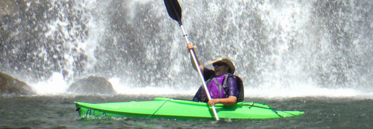
Just past the shoals we came to a lonely looking island that needed another geocache, and of course Rob was happy to oblige. After we had paddled 3/10 mile from that island, we noticed a small waterfall spilling into the river on our right, and paddled over to investigate it. This turned out to be Hice Branch. It was only a small flow, but we could see that after several rainy days it would be much more impressive. Rob decided that this spot also needed a geocache, so while he looked for a good spot, I explored the area a little more. It appears to be accessible by land via an overgrown trail. I didn’t follow it very far, so I’m not sure if it connects to the park or just leads to the road nearby. It doesn’t seem to get a lot of activity though. We were glad to see that the area isn’t trashed up like many of our spots of natural beauty are.
As we headed downstream, much of our journey was at a slow pace on this wide, calm river. Just past Hice Branch we encountered the first set of rapids that we paddled, H Earnests Shoals. These were very tame, but gave us the opportunity to get a little bit of a splash.
The weather was perfect for paddling. The day started out on the coolish side, and never got too terribly warm. The sun was shining, and the skies were a brilliant blue. There is no industry along this stretch of river, and the houses are few and far between. We did not encounter any other boaters, but did see a few folks swimming here and there. This is a much warmer river than the Watauga or South Holston. The only fishermen we saw were two young boys at Gillespies Shoals.
We saw a few blue herons along the way, but were also treated to the sight of ospreys, a cormorant and one lone bald eagle. We also saw a season (the proper name for a group) of killdeers along one rocky beach. At one point, we saw a trio of very large vultures along the shore, but quickly paddled by them so they would not get the wrong idea about our health.
Two miles into our trip, we passed under the Chuckey Pike Bridge. Just past the bridge, we investigated the sound of water and found a nice cascade on Rheatown Creek. Above this spot near the road is the historic Henry Earnest Fort House which was dedicated in May 2016 as a Historic Site in Methodism. This three-story house dates from about 1780 and was a frequent stop for Bishop Francis Asbury in the late 1700’s and early 1800’s as he traveled the area to preach and preside over conferences.
We spent some time enjoying the sights and sound of the water, and took a few photos of the cascade before continuing our trip downriver.
We passed through L Earnests Shoals shortly afterward, another small rapid that mostly consisted of a few pleasant ripples. Then, at the four mile mark we saw a sight that caused us to pause in our paddling. High atop a rock formation someone had built a deck overlooking the river. While it was very striking perched high on the rocks, we were not convinced of its structural integrity as the support posts did not seem to be of adequate size. We had the opportunity to further critique the builders’ choices when we noticed another deck built closer to the water level that used two stumps as its foundation. Old stumps do eventually rot away, you know.
Next up were the F Earnests Shoals (are you seeing a pattern here?) another tame little, short rapid. From there it was another ¾ of mile or so of flat water paddling. Rob suggested that once we stopped for our first cache that we take a lunch break, and my stomach was very happy with that suggestion.
Finally, we reached the first goal for the day, Cane Island. On this island our friend Ang had hidden a geocache on July 17, 2016 that had not yet been found. In his cache description, Ang had written, “Hear me now and believe me later, this place is infested with river cane galore.” He was right.
We pulled in to a very narrow beach, and then walked along it about 50 feet to find a spot we could safely climb the embankment. Once on level ground, we had to wade through waist high river cane back in the direction we had come. Mixed in with the river cane were thorns and numerous spider webs. The compasses on our phones were pointing this way and that, and we would walk for yards, stop, consult our phones only to see that according to them we were no closer than when we started. Rob said for about the 50th time, “I hope this cache is still here and hasn’t washed away.” We eventually turned around and started retracing our steps when suddenly Rob shouted, “I see it!” Perspective is everything. We had walked right past it, but it was on the opposite side of a tree so we didn’t see it. Oh, and it was almost right above where our boats were parked on the beach. We were thrilled to be able to sign our names to the empty log sheet.
We returned to our boats and decided that this beach was not a good lunch spot, so we paddled across the river to a much nicer spot where we could lounge on rocks and enjoy our meal. We also took that opportunity to check in with our significant others.
After lunch, our next goal was Lost Island where a second unfound cache was awaiting us. We paddled to the left of the island through Howard Shoals, and then stopped off to see if we could find a good spot for Rob to hide another new cache. He had researched the island and noticed that it was large enough to support more than one.
The spot where we stopped was majorly creepy. There were things hanging in the trees that made this place look like the set for the TV show “Lost”. Just the kind of spot we love to hide caches in. After Rob took care of business, we got back in our boats and paddled to the end of the island to find Ang’s other cache. Once again, we were greeted with a beautiful, blank log sheet and that great feeling of being the first to find.
Shortly after leaving Lost Island, we reached a point of the river that had been at the back of our minds the whole trip, Sinking Creek Shoals. We had been told by Ang that it was a fierce rapid, and that he and his paddling companion had chosen to walk their boats around it. We had looked at it on Google Maps, and it did look intimidating.
We passed a family that was swimming at a beach around the bend from the shoals, and the father asked us if we knew about the next rapids. We told him we were planning to scout it before running it, and he offered advice on how he usually does it. We decided we still wanted to check it out for ourselves, so when we approached, we beached our boats and walked across the rocks to see it for ourselves.
After studying the situation, we decided that the best route was basically down the middle. We could not see any real obstacles, but of course had no idea what might be lurking beneath the water. We agreed to go one at a time, so that we could take photos and video of each other. I elected Rob to go first.
His run went smoothly, and the “WOOOO!” that he shouted let me know that it was a fun ride. At one point, his canoe almost completely disappeared under a wave. He told me later that he had five or six inches of water in his boat and had a tough time paddling it to shore.
Now that it was my turn, I scrambled eagerly over the rocks (tripping a time or two since I was still in those stupid Crocs), climbed in my boat, and paddled to the top of the rapid. It was just as fun a ride as I expected, and I gave my own shout of joy as I plowed through the huge wave at the bottom. I was very happy for my skirt that kept all that water from swamping my boat. If I had been in an open kayak, it would have likely washed right out from under me.
The next mile or so of river was very tame, and a slow steady paddle. But then, we noticed the opening of a creek that flowed into the river and decided to paddle up it to investigate. This turned out to be Horse Creek. If you were to follow this creek on foot for about 7 ½ miles, you would arrive at the Horse Creek Park where we started our hike to Squibb Creek Falls back in January.
We soaked in the view of this peaceful creek and enjoyed the cool shade for a bit. Rob suggested that another geocache be hidden here, and I volunteered to do it since I had a container handy in my dry bag. Finding this cache will involve a small amount of rock climbing, but nothing too strenuous or dangerous.
As we left Horse Creek, we noted that the next geocache we planned to search for was only 6/10 mile away as the crow flies. However, because of a big bend in the river, that translated to over 1 ½ miles of paddling. Along the way were a few ripples, but most of the way was calm water and our arms were growing tired of paddling. Arriving at what the hider of that geocache had named Leroy Island (after himself) we found a fun little rapid flowing past it that helped to break the monotony. We found the geocache easily, and were soon back in our boats for the last ¾ of a mile or so of our trip.
We passed a house high atop the cliffs that had a very impressive series of decks and steps spanning a gap in the rocks. We wondered how on earth they completed this engineering feat.
There was one more small set of rapids as we approached the take out point, and once through them Rob beached his boat on an island to hide one more geocache. We then made our way to the boat ramp and loaded our boats in my truck for the shuttle back to our launch point. But first, we stopped at the top of the hill to replace a ten year old geocache that had gone missing last year and was in danger of being archived.
After nearly six hours on the river I was tired, a little sunburned, but very happy. This was a most excellent day and I hope to paddle this river again.


